Give us feedback!


 See all

Our philosophy is simple. We want to encourage you to dream. BIG! Then we help you plan your trip, get the most out of it while you're traveling and help you share your experience with friends.
Join Now It's FREE
Dream Packages
Duration: 8 hours
Price: $83.37
Price: $83.37
Duration: 2 days
Price: $242.00
Price: $242.00
Duration: 9 hours
Price: $109.14
Price: $109.14
Duration: 3 hours
Price: $173.83
Price: $173.83
Dreams Still To Do
Checked-Off Dreams
Dreams Still To Do
Checked-Off Dreams
Advertisement
Explore Adventure Sports
-
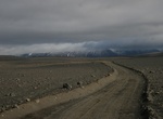
Off-road Sprengisandsleið (F26), Iceland
Route F26 or Sprengisandsleið is a highland gravel road in Iceland, running through the Sprengisandur area between the glaciers Hofsjökull and Vatnajökull. Route F26 is only for rugged 4WD vehicles with good clearance. The road's opening date varies, but usually falls at the end of June. Note: Rented cars are not allowed on either road as F roads are us... -
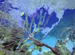
Snorkel Spring Bay, Virgin Gorda, British Virgin Islands
Spring Bay is a beautiful beach sprinkled with boulders and covered in white sand. No bars, just low key. Cannot be reached from The Baths, but has easy public access from Tower Road. The Crawl (more boulders!) has sheltered pools with almost no wave action, as well as rocks to climb and crevices to explore. Snorkeling is best around the rocks at The Crawl and at the ... -
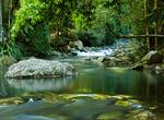
Explore Springbrook National Park, Queensland, Australia (UNESCO site)
Springbrook National Park is a national park at Springbrook on the McPherson Range in the Gold Coast hinterland of Queensland, (Australia), 96 km south of Brisbane. It is part of the Shield Volcano Group of the World Heritage site Gondwana Rainforests of Australia (formerly known as the Central Eastern Rainforest Reserves). In December 1994, the UNESCO World Heritage ... -
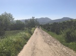
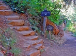
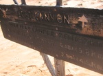
Hike Spring Canyon, California
The hike up Spring Canyon starts at the East Fortuna Staging Area. It's about 0.7 miles to the Route 52 bridge. At this point the trail leaves Mission Trails park. At mile 0.95 the road forks. Take the left fork up the little and then turn right to following the trail up the canyon. There is a single track just before this turn or continue up the initial road to mile... -
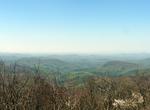
Explore Springer Mountain, Georgia
Springer Mountain is located in the Chattahoochee National Forest in Fannin County of northern Georgia. It is now the southern terminus of the Appalachian Trail. In 1958, the southern terminus of the Appalachian Trail was moved from Mount Oglethorpe approximately 14 miles (23 km) to the northeast to Springer Mountain because of increased development around Mount Oglet... -
Hike Spruce Canyon Trail, Mesa Verde National Park, Colorado
Begins from the Spruce Tree House trail, follows the bottom of Spruce Tree Canyon, turns up Spruce Canyon, and returns to the museum via the picnic area. The trailhead is located near the Chapin Mesa Archeological Museum. Please contact a ranger for times the gate above the trailhead is open. Registration at the trailhead or museum is required. The Spruce Canyon Trail... -
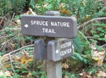
Hike Spruce Nature Trail, Olympic National Park, Washington
Spruce Nature Trail is a 1.2 mile loop trail beginning near the Hoh Visitor Center. -
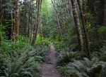
Hike Spruce Railroad Trail (Lake Crescent Trail), Olympic National Park, Washington
The Spruce Railroad Trail (sometimes called Lake Crescent Trail) is a rail trail located on the shores of Lake Crescent about 20 miles (32 km) west of Port Angeles, Washington. The trail follows the former Port Angeles Western Railroad grade along the shores of Lake Crescent. The trail is approximately 4 miles (6.4 km) one way, and trailheads exist at both ends. ... -
Canyoneer Spry Canyon, Zion National Park, Utah
Spry Canyon is a fun and challenging slot canyon to explore. The canyon has easy access, 10-11 challenging rappels (longest 165 feet), a cold water swim and 95' mostly free hanging rappel finish - what else can you ask for? The canyon is 4.3 miles long and will take 6-8 hours to complete. Spry Canyon is located between Twin Brothers and The East Temple with a drop in... -
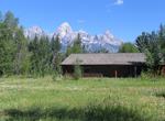
Stay at Spur Ranch Cabins, Grand Teton National Park, Wyoming
Dornan's Spur Ranch is a small, family-owned resort, with 8 one bedroom and 4 two-bedroom duplexes. Built in 1992, the cabins are furnished with handcrafted lodge pole pine furniture. The bedrooms feature queen sized beds with down comforters. The kitchens are fully equipped. Each cabin has a covered porch to enjoy the Tetons views and BBQ grills are next to the porch... -
Hike to top of Spy Glass Hill, Norman Island, BVI
Frm The Blight on Norman Island enjoy a great hike up to the top of Spy Glass Hill to experience a 360 degree view of the Sir Francis Drake Channel. -
Dive or Snorkel Spyglass Wall, Norman Island, BVI
Just east of The Bight on Norman Island is the Spyglass Wall dive site. It offers fantastic sponge and fish covered mini-wall dropping from 20' to 60'. Spyglass Wall is one of the best mini walls in British Virgin Islands. The site can also be snorkeled in the shallow spots. -
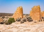
Hike Square Tower Loop Trail (Little Ruin Canyon), Hovenweep National Monument, Utah
This trail begins at the Canyon Overlook and loops around Little Ruin Canyon. The loop trail is primitive, passing over slickrock and packed dirt, and is lined with rock. As you wind around the canyon, you pass within 5-10 feet of most of the Square Tower Group structures, allowing an uninterrupted and natural view of these architectural wonders. Part of the trail ent... -
Hike Squaw Canyon/Lost Canyon Loop, Canyonlands National Park, Utah
The 8.7 miles (14 km) Squaw Canyon to Lost Canyon hike in Canyonlands National Parkis similar to the Big Spring to Squaw Canyon loop, but travels deeper into a canyon. Three backpacking sites. Water reliably available. The hike starts at Squaw Flats trailhead, which is located along the south side of the Squaw Flats Loop “A” road. A few hundred yards past ... -
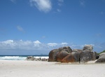
Visit Squeaky Beach, Victoria, Australia
One of the most popular walks for campers staying at the Tidal River campsite is the 3-kilometre (1.9 mi) Squeaky Beach walk, an enjoyable walk which passes over the ridge separating Norman and Squeaky Beach. As its name suggests, Squeaky Beach, squeaks when walked on. This is due to the ultra-fine quartz sand particles, all of which are the same size and shape. The b...


Price: $208.72