Give us feedback!


 See all

Our philosophy is simple. We want to encourage you to dream. BIG! Then we help you plan your trip, get the most out of it while you're traveling and help you share your experience with friends.
Join Now It's FREE
Dream Packages
Duration: 3 hours 30 minutes
Price: $99.36
Price: $99.36
Duration: 2 days
Price: $469.00
Price: $469.00
Duration: 15 hours
Price: $149.00
Price: $149.00
Duration: 3 hours
Price: $173.83
Price: $173.83
Dreams Still To Do
Checked-Off Dreams
Dreams Still To Do
Checked-Off Dreams
Advertisement
Explore Adventure Sports
-
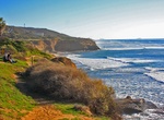
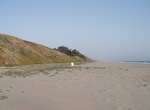
Explore Sunset Cliffs Natural Park, Point Loma, San Diego
Sunset Cliffs is a neighborhood in the Point Loma community of San Diego, California. It is bordered by the Pacific Ocean on the west, Ocean Beach on the north, Catalina Blvd. and Santa Barbara St. on the east, and Sunset Cliffs Natural Park on the south. During Spring and Fall, keep your eyes open for migrating Gray Whales only a few miles out to sea. The area is nam... -
Watch Sunset from Nungwi Beach, Zanzibar
Nungwi is a fishermen's village and beach located at the northern most tip of Unguja (Zanzibar), East Africa. In the past it was mostly known as a dhow boatyard. Until the 1990s, the local population was opposed to tourism, so Nungwi's beach is one of the last in the area to host hotels and other touristic structures. This situation has since changed, and the main bea... -
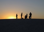
Go on Sunset Guided Stroll, White Sands National Monument, New Mexico
The Sunset Stroll is a leisurely, ranger-guided stroll through the gypsum sand dunes. It is a splendid opportunity to experience the dunes first-hand while learning about the uniqueness of our geology, plants, and animals. As an added bonus, the stroll is timed to end at sunset, providing a panoramic view of the sun setting over the mountains and the potential for som... -
Hike Sunset Loop, Peter Island, BVI
The Sunset Loop hike on Peter Island is the BVI's is about 5 miles round trip and follows the occocially used resort road. The hike leads to the island’s summit with the 1.5 miles to the summet being pretty steep. Anyone can visit Peter Island, but you have to be a quest Peter Island Resort to stay overnight on the island. Make sure to time the hike to catch th... -
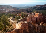
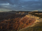
Hike Sunset Point to Sunrise Point Trail, Bryce Canyon National Park, Utah
Observe the amphitheater and it's hoodoos along the rim and if planned right, visit all four main viewpoints. Sunset Point to Sunrise Point Rim Trail is paved and fairly level. -
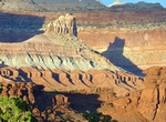
Hike Sunset Point Trail, Capitol Reef National Park, Utah
The short hike (0.3 mile) to Sunset Point offers a great place to see dramatic views over Capitol Reef’s rock formations as the sun sets. It has a minimal elevation gain. The Sunset Point Trailhead is at the Goosenecks Overlook parking lot. -
Camp Sunset State Beach, Watsonville, California
Sunset State Beach is a park and beach on Monterey Bay, in Santa Cruz County, California. It is operated by the California Department of Parks and Recreation. It is approximately 1.5 miles (2.5 km) long, and located near Watsonville. It is surrounded by large agricultural fields west of the city of Watsonville. Manresa State Beach is to the north-upcoast of Sunset Sta... -
Stroll Sunset Strip, West Hollywood, California
The Sunset Strip is the name given to the mile-and-a-half (2.4 km) stretch of Sunset Boulevard that passes through West Hollywood, California. It extends from West Hollywood's eastern border with Hollywood at Havenhurst Drive, to its western border with Beverly Hills at Sierra Drive. The Strip is probably the best-known portion of Sunset, embracing a premier collectio... -
Hike Sunset Trail, Hot Springs National Park, Arkansas
The Sunset Trail is the longest trail in Hot Springs National Park, covering more than 10 miles. Crossing all types of terrain, the trail passes by the highest elevation in the park as well as Ricks Pond and also makes its way through the most remote areas of the park. You can expect to find quite a variety of wildlife in these less frequented pockets, which serve as ... -
Hike Sunset Trail, Cedar Breaks National Monument, Utah
This accessible paved trail, runs between the Point Supreme Overlook and Sunset View Overlook. The park picnic area is located at the half-way point of this trail. Built to offer all ages and abilities the opportunity to enjoy a walk in the woods and avoiding steep grades, this trail provides gentle slopes and offers many rest areas. This is the only trail where ... -
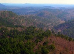
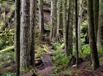
Hike Sunset Trail (Sunrise Highway), San Diego, California
Truly a Gem of the Laguna Mountain and the Cleveland National Forest, the Sunset trail takes hikers traversing through dense forest, vast meadows, grazing cattle, gorgeous viewpoints and during a wet year, a pond and several large lakes. On a clear day, this trail offers impressive panoramic views of mountain ranges, the Pacific Ocean and downtown San Diego. Listed as... -
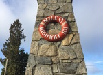
Drive Sunshine Coast Highway (Hwy 101), BC, Canada
British Columbia Highway 101, also known as the Sunshine Coast Highway, is the main north-south thoroughfare on the Sunshine Coast, British Columbia, Canada. Highway 101, which first opened in 1962, is divided into two separate land segments, with a ferry link in between. The highway is maintained by Capilano Highway Services. Despite its location on the mainland, the... -
Hike Sunshine Coast Trail, British Columbia, Canada
The 180 kilometres (110 mi) Sunshine Coast Trail is Canada's longest hut-to-hut hiking trail, and travels from mountains to shorelines and lakes. Beginning at Sarah Point in Desolation Sound and ending at Saltery Bay, it is free to everyone, and hikers can enter and leave it at multiple points. -
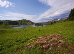
Hike to Sunshine Meadows, Banff National Park
The Sunshine Meadows are a natural garden set at an altitude of approximately 2,300 metres (7,500 feet). It is located within the peaks of the Canadian Rocky Mountains of Banff National Park. From the vantage point of Sunshine Meadows one has a clear view of Mount Assiniboine, the highest peak in the region at 3,618 metres (11,870 feet). Sunshine Meadows is located 18... -
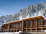
Ski / Snowboard Sunshine Village, Banff National Park
Sunshine Village is a Canadian ski resort, located on the Continental Divide of the Canadian Rockies within Banff National Park in Alberta and Mt Assiniboine Provincial Park in British Columbia, Canada. It is one of three major ski resorts located in the Banff National Park. Because of its location straddling the Continental Divide, Sunshine receives more snow than th...


Price: $106.33