Give us feedback!


 See all

Our philosophy is simple. We want to encourage you to dream. BIG! Then we help you plan your trip, get the most out of it while you're traveling and help you share your experience with friends.
Join Now It's FREE
Dream Packages
Duration: 4 hours
Price: $120.43
Price: $120.43
Duration: 7 hours
Price: $179.00
Price: $179.00
Duration: 8 hours
Price: $220.83
Price: $220.83
Duration: 6 days
Price: $606.00
Price: $606.00
Dreams Still To Do
Checked-Off Dreams
Dreams Still To Do
Checked-Off Dreams
Advertisement
Explore Adventure Sports
-
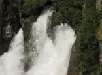
See Tarawera Falls, New Zealand
Tarawera Falls is a 35 m high waterfall on the Tarawera River in the Bay of Plenty region in New Zealand's North Island. The Tarawera River flows out of Lake Tarawera and across a rhyolitic lava flow that erupted from Mt Tarawera about 11,000 years ago. The river disappears into flooded caves in the lava and pours out halfway up the cliff on the far side of the flow. ... -
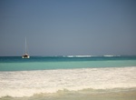
Surf Tarimbang Bay, Sumba Island, Indonesia
Tarimbang Bay is 120 kilometres from Waingapu, a three-hour drive. It is a surfers paradise with 2- to 3-meter tall waves between June and September. -
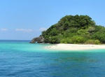
Explore Tarutao National Park, Thailand
Tarutao National Park consists of 51 islands in the Strait of Malacca, off the coast of Satun Province of southern Thailand. The Tarutao National Park consists of two island groups:Tarutao andAdang-Rawi, which are scattered from 20 to 70 kilometres' distance from the south-westernmost point of mainland Thailand. The park covers an area of 1,490 square kilometres (1,26... -
Hike to Tarzan Falls, Guam
The hike to Tarzan Fallsis along a scenic, shaded trail. -
Explore Tasek Merimbun, Borneo, Brunei
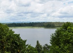
Tasek Merimbun is the largest natural lake in Brunei. It is located near Mukim Rambai in the Tutong District, about 70 km from the capital, Bandar Seri Begawan. The S-shaped lake is located 27 km from Tutong Town and it is surrounded by the 7800-hectare Tasek Merimbun Heritage Park. Tasek Merimbun is dark in color; a phenomenon generated by tannin coming from leaves f... -
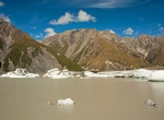
See Tasman Glacier & Tasman Lake, New Zealand
The Tasman Glacier is the largest of several glaciers which flow south and east towards the Mackenzie Basin from the Southern Alps in New Zealand's South Island. It is New Zealand's longest glacier. At 27 kilometres (17 mi) in length, Tasman Glacier is New Zealand's longest glacier.It is as much as 4 kilometres (2.5 mi) wide and 600 metres (2,000 ft) thick, and l... -
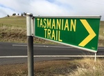
Trek the Tasmanian Trail, Tasmania, Australia
The Tasmanian Trail is a long distance path in Tasmania, Australia. This long-distance multi-use trail stretching from the northern town of Devonport south to Dover. It was inspired by the Bicentennial National Trail opened on the mainland in 1988. It runs from Devonport in the north of the state to Dover in the South East and is 460 km long. It consists of 15 section... -
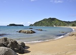
Visit Tata Beach, New Zealand
Tata Beach is a beach and small coastal settlement of predominantly holiday houses in the South Island, New Zealand. Found in the Golden Bay region, it is approximately 20 kilometres (12 mi) north-east of Takaka. -
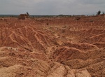
Explore Tatacoa Desert, Colombia
The Tatacoa Desert is the second largest arid zone in Colombia after the Guajira Peninsula. It occupies 330 square kilometers of land. This semiarid region is located north of Huila Department, 38 km from the city of Neiva in Colombia and 15 km (9 mi) from Natagaima in Tolima. It is a rich deposit of fossils and is a great tourist destination. The Tatacoa Desert has t... -
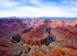
Off-road to Tatahatso Point, Arizona
Tatahatso Point overlooks Point Hansbrough and the Colorado River in north-central Arizona. Hiking Permit from office Lake Powell Navajo Tribal Park -
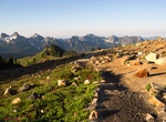
Hike Tatoosh Range, Mount Rainier National Park, Washington State
The Tatoosh Range is a mountain range located in Mount Rainier National Park and the adjacent Tatoosh Wilderness in the state of Washington, in the Pacific Northwest region of the United States. The range runs roughly east–west, beginning with the southeastern Moon Mountain and concluding with the western Rainbow Mountain and Eagle Peak. The range includes 25 pr... -
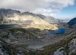
Explore Tatra Mountains, Slovakia & Poland
The Tatra Mountains are a mountain range which forms a natural border between Slovakia and Poland, and are the highest mountain range in the Carpathian Mountains. The Tatras should be distinguished from another Slovak mountain range, the Low Tatras, Slovak:Nízke Tatry, located south of the Tatra mountains. Sometimes,Tatrasis a term used for either or both range... -
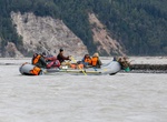
Raft Tatshenshini River (Yukon & British Columbia), Canada
This is an extremely beautiful and exciting rafting river that flows through Yukon and into Alaska. Put-in is approximately a 3 hour drive from Whitehorse, Yukon, on the Haines Road. On a day trip, you will experience grade II to IV rapids. Sightings of grizzly bears, bald eagles and spawning salmon are common. -
Ride Tatsu (Fying Roller Coaster) Valencia, California
Tatsuis a steel flying roller coaster operating at Six Flags Magic Mountain in Valencia, California. It opened May 13, 2006. The ride was promoted with a Japanese mythology theme with Tatsu meaning Dragon in Japanese. Tatsu is the only flying coaster to have a Zero-G Roll. It is also the world's tallest, fastest, and longest flying coaster. Built by the Swiss roller c... -
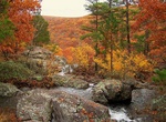
Hike Taum Sauk Mountain, Iron County, Missouri
Taum Sauk Mountain in the Saint Francois Mountains is the highest natural point in the U.S. state of Missouri at 1,772 feet (540 m). The topography of Taum Sauk is that of a somewhat flat ridge rather than a peak. While not as impressive at 1,772 feet (540 m) as other peaks, Taum Sauk and the St. Francois range are true mountains, being the result of a volcanic orogen...

Price: $83.37