Give us feedback!


 See all

Our philosophy is simple. We want to encourage you to dream. BIG! Then we help you plan your trip, get the most out of it while you're traveling and help you share your experience with friends.
Join Now It's FREE
Dream Packages
Duration: 8 hours
Price: $220.83
Price: $220.83
Duration: 3 hours
Price: $140.24
Price: $140.24
Duration: 8 hours
Price: $208.72
Price: $208.72
Duration: 7 hours
Price: $144.00
Price: $144.00
Dreams Still To Do
Checked-Off Dreams
Dreams Still To Do
Checked-Off Dreams
Advertisement
Explore Adventure Sports
-
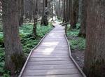
Hike Trail of the Cedars, Glacier National Park, Montana
The Trail of the Cedars is a hiking trail accessible from Going-to-the-Sun Road in Glacier National Park, Montana. The .60 miles (0.97 km) path is paved and has a raised boardwalk in some sections. Some of the cedars visible are over 80 feet (24 m) tall. The trail splits into two sections: one loops, while the other continues to Avalanche Lake which can reached after ... -
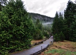
Hike Trail of the Shadows, Mount Rainier National Park, Washington
The Trail of the Shadows loop trail (0.7 mi/1.1 km) is an easy walk past one of the park's earliest homesteads, the Longmire hot springs, and through the surrounding forest. -
Hike Trail of Time (Million Year Trail), Grand Canyon National Park, Arizona
The Trail of Time is an 2.83 mile (4.56 km) one-way interpretive walking trail that focuses on Grand Canyon's vistas and rocks, encouraging visitors to ponder, explore, and understand the magnitude of geologic time and the stories told by canyon's rock layers and landscapes. Walking the trail is intended to give park visitors a visceral appreciation for the magnitude ... -
Hike Trail of Time Trail, Mendenhall Glacier, Alaska
Trail of Time Trail is 1 mile (1.6 km) loop from Mendenhall Glacier Visitor Center. -
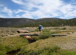
Hike Trail Pass to PCT, Horseshoe Meadow, California
"Trail Pass" provides access to the Pacific Crest Trail going South and the northeastern portion of Golden Trout Wilderness. Small streams meander through tree-rimmed meadows in this wilderness area, which is named for California's state fish. This trail is popular with horseback riders because the trail is gener-ally well-maintained and has a gentle grade. Download ... -
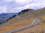
Drive Trail Ridge Road, Rocky Mountain National Park, Colorado
Trail Ridge Road is the name for a stretch of U.S. Highway 34 that traverses Rocky Mountain National Park from Estes Park, Colorado in the east to Grand Lake, Colorado in the west. The road is also known as Trail Ridge Road/Beaver Meadow National Scenic Byway. Trail Ridge Road is closed during the winter, and often remains closed until late spring or early summer depe... -
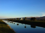
Hike along Tralee Ship Canal, Tralee, Ireland
The Tralee Ship Canal is a canal built for freight and passenger transportation from Tralee Bay to the town of Tralee in County Kerry, Ireland. The canal fell into disuse in the mid-20th century but has since been restored. The Tralee Ship Canal was built to accommodate larger ships sailing into Tralee as the quay in Blennerville was becoming unpractical to use due to... -
Drive Tram Ton Pass, Sapa, Viet Nam
Tram Ton Pass is the highest pass in Vietnam, located in mountains. There is the Silver Waterfall on the way and the views are amazing when you ride a motorbike. -
Hike Tramway Trail to Echo Lake, Catalina Island, California
The Tramway Trail to Echo Lake is the most strenuous out of White's Landing. Hikers can return via the moderate White's Road (3.4 miles one way) or Wandering Bison Trail (2.8 mile one way). -
Visit Tràng An Scenic Landscape Complex, Vietnam (UNESCO Site)
Tràng An is a scenic area near Ninh Bình, Vietnam renowned for its boat cave tours. On 23 June 2014 at the 38th session held in Doha, Trang An Scenic Landscape Complex was inscribed on the UNESCO World Heritage Site. Trang An Scenic Landscape Complex included Hoa Lư, Tam Cốc-Bích Động, Bai Dinh Temple. Exploration of some of the highest altitude... -
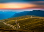
Drive Transalpina (DN67C), Romania
The Transalpina or DN67C located in the Parâng Mountains group, in the Southern Carpathians of Romania, is one of the highest roads of the Carpathian Mountains. It connects Novaci, south of Parâng Mountains, to Sebeş in the north. It is said that the road was built under King Carol II and rebuilt during World War II by German troops and it is calledThe Kin... -
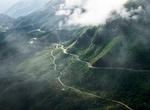
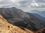
Trek Trans Bhutan Trail, Bhutan
The Trans Bhutan Trail is a 403-kilometre (250 mi) east–west trail in Bhutan, stretching from Haa to Trashigang and crossing 27 gewogs across nine dzongkhags. While some sections are accessible for a casual afternoon stroll, others involve multi-day hikes at high altitude, potentially reaching 3,900 to 4,000 meters. The full 403km trail, stretching across Bhutan... -
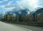
Drive Trans-Canada Highway (Hwy 1), Revelstoke to Lake Louise, Canada
The Trans-Canada Highway (Highway #1) is a transcontinental federal-provincial highway system that travels through all ten provinces of Canada between its Pacific Ocean and Atlantic Ocean coasts to the west and east respectively. The 220-km portion of the Trans-Canada Highway between Revelstoke and Lake Louise goes through the Canadian Rockies, including the Selkirk ... -
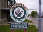
Hike Trans Canada Trail
The Trans Canada Trail is the world's longest network of recreational trails. When fully connected, the Trail will stretch 23,000 kilometres (14,000 mi) from the Atlantic to the Pacific to the Arctic oceans. More than 16,800 kilometres (10,400 mi) of trail are currently usable, making it approximately 73% complete in 2012. Two hundred forty gaps totaling 6,200 kilomet... -
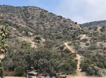
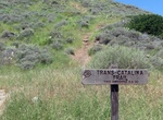
Hike Trans-Catalina Trail (TCT), California
The Trans-Catalina Trail on Santa Catalina Island in California starts from the city of Avalon on the eastern tip to Parson’s Landing (or Starlight Beach) on the western end of the island. The trail is officially 38.5 miles but is really about 40-50 miles since hikers have to get back to Two Harbors from Parson's Landing or Starlight Beach. Avalon to Black Jack...


Price: $173.83