Give us feedback!


 See all

Our philosophy is simple. We want to encourage you to dream. BIG! Then we help you plan your trip, get the most out of it while you're traveling and help you share your experience with friends.
Join Now It's FREE
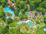
Dream Packages
Duration: 6 days
Price: $606.00
Price: $606.00
Duration: 15 hours
Price: $149.00
Price: $149.00
Duration: 2 days
Price: $469.00
Price: $469.00
Duration: 3 hours 30 minutes
Price: $99.36
Price: $99.36
Dreams Still To Do
Checked-Off Dreams
Dreams Still To Do
Checked-Off Dreams
Advertisement
Explore Adventure Sports
-
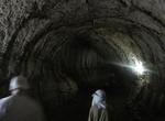
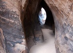
Explore Tunnel of Endless Love, Santa Cruz Island, Galápagos
Santa Cruz island is riddled with lava tubes. Lava tubes are natural conduits through which lava travels beneath the surface of a lava flow, expelled by a volcano during an eruption. They can be actively draining lava from a source, or can be extinct, meaning the lava flow has ceased and the rock has cooled and left a long, cave-like channel. “The Tunnel of End... -
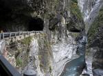
Drive or Cycle Tunnel of Nine Turns, Taroko Gorge, Taiwan
The Tunnel of Nine Turns is located in Taroko Gorge, Taiwan. The rivers water that produced many curves in the gorge. A road has been carved out of the cliff face with an endless set of turns - hense the name of the road. The Tunnel of Nine Turns is actually a 2km section of the original highway through the park. The marble cliff face opposite the road varies in colo... -
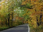
Drive Tunnel Of Trees (M-119), Michigan
The Tunnel of Trees is so named for the hardwoods and evergreens that crowd up to the edge of the road, their crowns knit into a comforting ceiling over motorists and bicyclists. But this isn’t like a tunnel through a mountain, where the view is basically the inside of a cave. -
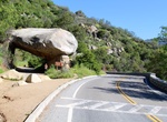
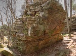
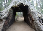
See Tunnel Rock, Sequoia National Park
Tunnel Rock is locatedon the Generals Highway near the Ash Mountain entrance to Sequoia National Park. A portion of the old highway which ran beneath the rock can still be seen here. -
Dive Tunnels and Arches, Thatch Cay, USVI
Tunnels and Arches dive site is located off the west end of Thatch Cay in the U.S. Virgin Islands. It's one of the most popular sites in the area due to a series of arches and tunnels - hense the name. -
Hike to Tunnel Slot Canyon, Utah
Tunnel Slot Canyon is located in Escalante National Monument in Utah. As the name implies, is a short section of slot resembling a tunnel. It's a very short slot and no obstacles, but has lots of moqui balls. To reach Tunnel Slot, go down Harris Wash a little less than a mile from Zebra Slot Canyon to the first side canyon coming in on the left. Go up this canyon to ... -
Hike Tunnel Trail, Grandview Visitor Center, West Virginia
Cool off along Grandview's shortest and shadiest trail. The moist earth, lush vegetation, and cold-to-the-touch sandstone walls make a stroll along this forest trail a special experience, even on the hottest day. The ½ mile trail passes several tunnels in the rock and passes beneath a large rock overhang. One end of the Tunnel Trail begins off the walkway to t... -
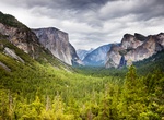
Visit Tunnel View, Yosemite National Park
Tunnel View is an scenic overlook on State Route 41 in Yosemite National Park. The iconic and expansive view of Yosemite Valley from the view point have been seen and documented by visitors since it opened in 1933. Internationally renowned artists to casual tourists have painted, drawn, and photographed the dramatic scenery from here and nearby vantage points since th... -
Explore Tun Sakaran Marine Park, Sabah, Malaysia
Tun Sakaran Marine Park, also known as Semporna Islands Park, is a marine park located off the east coast of Sabah, Malaysia. It consists of the islands of Bodgaya, Boheydulang, Sabangkat, and Salakan, the sand cays of Maiga, Sibuan, and Mantabuan, and the patch reefs of Church and Kapikan. In 2004, the park became the seventh gazetted area under Sabah Parks with a to... -
Hike Tuolumne Grove Trail, Yosemite National Park, California
Tuolumne Grove Trail initially follows the Old Big Oak Flat Road, one of the first roads into Yosemite Valley. Tuolumne Grove contains a couple dozen mature Giant Sequoias, including one you can walk through (although it's dead). -
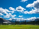
Explore Tuolumne Meadows, Yosemite National Park, California
Tuolumne Meadows is a gentle, dome-studded sub-alpine meadowy section of the Tuolumne River, in the eastern section of Yosemite National Park. Its approximate elevation is 8619 feet (2627 m). Tuolumne Meadows has a good view of the Cathedral Range (in the background of the image, looking south), Lembert Dome and Mount Dana (to the north). Camping is available at the T... -
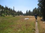
Hike Tuolumne Meadows to Yosemite Valley, Yosemite National Park, California
Many hikers chose to hike from Tuolumne Meadows to Yosemite Valley starting at Tenaya lake, but this hike offers a slight different perspective, and allows you to stop at the Merced Lake High Sierra Camp as well. The hike is 28 miles and can be completed in 2 days with an overnight stop at Merced Lake, or can be stretched to as many as 4 days with extra nights at Voge... -
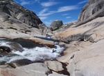
Raft or Kayak Tuolumne River, Yosemite National Park, California
The Tuolumne River flows for 149 miles (240 km) through Central California, from the high Sierra Nevada to join the San Joaquin River in the Central Valley. Originating at over 8,000 feet (2,400 m) above sea level in Yosemite National Park, the Tuolumne drains a rugged watershed of 1,958 square miles (5,070 km2), carving a series of canyons through the western slope o... -
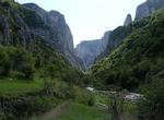
Rock Climb Turda Gorge (Cheile Turziiin), Romania
Turda Gorge (Cheile Turziiin) is a natural reserve on the Hășdate River located 6 km west of Turda and about 15 km south-east of Cluj-Napoca, in Transylvania, Romania. The canyon, formed through the erosion of the jurasic calcar of the mountain, is 2 900 m long and the walls have heights reaching 300 m. The total surface of the canyon is of 324 ha. Cheile Turzii conta... -
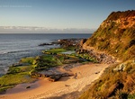
Stroll Turimetta Beach, Sydney, Australia
Turimetta Beach is a beach in Sydney's Northern Beaches. It is 350 metres long and is backed by steep bluffs. Swimming can be hazardous because of rips that usually form at the centre and both ends of the beach. The beach is not patrolled by lifeguards. Turimetta is more often than not a swimmers' beach only. The surf quality is poor and surfers usually frequent North...
Price: $179.00