Give us feedback!


 See all

Our philosophy is simple. We want to encourage you to dream. BIG! Then we help you plan your trip, get the most out of it while you're traveling and help you share your experience with friends.
Join Now It's FREE
Dream Packages
Duration: 2 days
Price: $242.00
Price: $242.00
Duration: 4 hours
Price: $120.43
Price: $120.43
Duration: 8 hours
Price: $83.37
Price: $83.37
Duration: 7 hours
Price: $144.00
Price: $144.00
Dreams Still To Do
Checked-Off Dreams
Dreams Still To Do
Checked-Off Dreams
Advertisement
Explore Adventure Sports
-
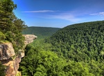
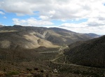
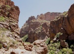
Hike Upper Buffalo Wilderness, Arkansas
Upper Buffalo Wilderness is located in the U.S. state of Arkansas. Created by an act of Congress in 1974, the wilderness covers an area of 12,108 acres (49 km²). Contained within Ozark-St. Francis National Forest, the wilderness is managed by the U.S. Forest Service. Contained in the wilderness is Hawksbill Crag (also called Whittaker Point), a very popular hikin... -
Hike Upper Burro Mesa Pour-off Trail, Big Bend National Park, Texas
This route follows a dry wash downstream to the top of the 100-foot Burro Mesa Pour-off. The trail includes some large rocks to climb down, where some rock scrambling may be necessary. Pay attention on the return hike to ensure that you follow the same drainages. Trail subject to flash flooding. Begin at pull-off, mile 6.6, Ross Maxwell Scenic Drive. -
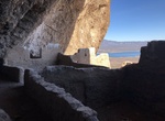
Go on Upper Cliff Dwelling Guided Tour, Tonto National Monument, Arizona
The Upper Cliff Dwelling is open by guided tours only. The trail is 3 miles (4.8 km) roundtrip and takes about 3 to 4 hours. Tours are offered to the Upper Cliff Dwelling November through April every Friday, Saturday, Sunday and Monday. Please call (928) 467- 2241 to check availability and make reservations. Space is limited, only 15 people are allowed on each tour. ... -
Hike Upper Cottonwood Wash, Utah
Upper Cottonwood Wash has been a well-traveled route throughout time. The Native Americans were the first to trailblaze this area hundreds of years ago before the arrival of the Spanish in the late 1400s. The trails most popular use occurred with the establishment of the Old Spanish Trail in 1829. Though the first official expedition occurred on the Armijo Route furth... -
Off-road Upper Coyote Canyon, Anza-Borrego Desert State Park, California
Coyote Canyon Until the mid 80’s this canyon was drivable all the way from the Terwilliger Valley to Borrego Springs City and back, now the 3.2 miles between the Upper willows and middle willows is permanently closed to motor vehicles year around. The trail is now divided in Upper Coyote Canyon and Lower Coyote Canyon and both of these sections are closed betwee... -
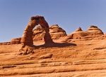
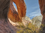
Hike to Upper Delicate Arch Viewpoint, Arches National Park, Utah
Take the short hike to Upper Delicate Arch Viewpoint in Arches National Park. -
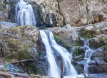
Hike to Upper Doyles River Falls, Shenandoah National Park, Virginia
Doyles River Falls Trail is a 3.4 mile out and back trail in Shenandoah National Park. -
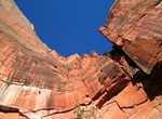
Hike Upper Emerald Pools Trail, Zion National Park, Utah
The Upper Emerald Pools Trail are closed until further notice due to storm damage. Upper Emerald Pools Trail starts at the top of the Lower Emerald Pools Trail. It's an easy hike to the lower pool, moderate to middle, strenuous to upper. Round trip distances are 1.2 miles to lower, 2 miles to middle and 3 miles to upper -
Hike Upper Fish Creek Canyon, Arizona
Fish Creek is a lengthy drainage that flows from the center of the Superstition Mountains in a north-westerly direction towards the Salt River, joining it just below Apache Lake. This short 1 mile out-and-back trail -
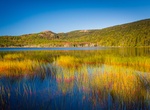
Fish Upper Hadlock Pond, Maine
Upper Hadlock is a scenic water with Norumbega Mountain rising up from the western shore. Access is easily gained over a road off Route 3 (198) several miles north of Northeast Harbor. This 35 acre pond has a nice hiking trail along the southern and eastern shoreline. The pond is known for brook trout and is stocked on a fairly regular basis. An occasional brown trou... -
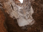
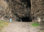
Hike to Upper Makua Cave (Kaneana Cave), Oahu, Hawaii
Makua Cave is located on Oahu's Leeward Coast 3 miles north of the Makaha town, about a mile after Keeau Beach Park. You may park your car across the cave. It's a short 20 minute hike to the cave and steep going up and challenging going down due to lots of crumbly rocks/dirt. The cave is about 100 feet high and 450 feet deep. Remember to bring a flashlight. The drive ... -
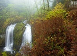
Hike to Upper McCord Creek Falls, Oregon
The hike to Upper McCord Creek Falls in Oregon starts at John B Yeon Trailhead and is about 2.2 miles roundtrip. Hikers will pass Elowah Falls on the way. -
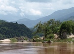
Cruise Upper Mekong, Laos
The Upper Mekong River where it flows through Laos and Cambodia has become a popular location for travelers wanting to sample the offerings of this Southeast Asian country from the comfort and convenience of a river ship. The Upper Mekong is subject to changeable conditions and requires somewhat more nimble craft to navigate through some of the potentially challenging... -
Explore Upper Missouri Wild and Scenic River, Montana
The Upper Missouri National Wild and Scenic River Management Plan highlights; the uniqueness, special values and wild and scenic qualities that were instrumental in the designation on October 12, 1976. Of special note is the fact that the Upper Missouri contains segments of all three river classifications contained in the Wild and Scenic Rivers Act of 1968. These clas... -
Hike Upper Muley Twist Canyon, Capitol Reef National Park, Utah
Upper Muley Twist Canyon in Capitol Reef National Park offers many options for side trips and off-trail exploring. It includes narrow canyons, expanses of slickrock, large arches, and dramatic vistas from the top of the Waterpocket Fold. It's 15 miles (24.1 km) roundtrip from the Upper Muley Twist Canyon trailhead (best done as an overnight hike). From the Strike Vall...
Price: $180.00