Give us feedback!


 See all

Our philosophy is simple. We want to encourage you to dream. BIG! Then we help you plan your trip, get the most out of it while you're traveling and help you share your experience with friends.
Join Now It's FREE
Dream Packages
Duration: 3 hours 30 minutes
Price: $99.36
Price: $99.36
Duration: 7 hours
Price: $179.00
Price: $179.00
Duration: 7 hours
Price: $144.00
Price: $144.00
Duration: 5 hours
Price: $106.33
Price: $106.33
Dreams Still To Do
Checked-Off Dreams
Dreams Still To Do
Checked-Off Dreams
Advertisement
Explore Adventure Sports
-
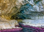
Boat to White Grotto (Grotta Bianca), Capri, Italy
The White Grotto is one of several scenic caves along the coastline of the island of Capri, which sits just off the coast of Naples, Italy. Less crowded than the popular Blue Grotto, it gets its name from the white stalactites that hang from the roof of the cave and the white layers of calcareous material that coats its sides. One of the stalactites is said to resembl... -
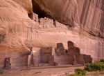
Hike White House Ruin Trail, Canyon de Chelly National Monument, Arizona
The White House Ruin Trail is a self-guided 2.5-mile hiking trail in Canyon de Chelly. This is the only trail which allows an un-escorted trip to the floor of the canyon, and well worth the effort. The walk back up is quite strenuous. Make sure to do the hike in the morning and take lots of water and sun block. -
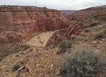
Hike White House Trailhead to Buckskin Gulch, Grand Staircase-Escalante National Monument, Utah
White House Trailhead to Buckskin Gulch is a 14.9 mile out and back trail that starts near Paria Contact Station. Most people do a several day backpacking trip ending at the Lees Ferry Trailhead, but this out-and-back route shown here provides a nice alternative. A permit and fee is required for hiking and overnight use in Buckskin Gulch. Pay for your permit at eith... -
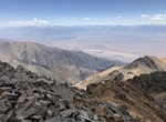
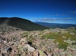
Summit White Mountain Peak, California
White Mountain Peak, at 14,252 ft, is the highest peak in the White Mountains of California, the highest peak in Mono County, and the third highest peak in the state after Mount Whitney and Mount Williamson. It is the fourteenth most topographically prominent peak in the contiguous United States. There is a winding dirt road leading to the summit station that is usual... -
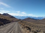
Offroad White Mountain Road, California
White Mountain Road is a very scenic mountain road located in White Mountains, Inyo County. It's starts from CA-168 road with the first 10.2 miles being paved. The remaining 18.1 miles is dirt. The road climbs up several mountain passes and runs entirely at 3.000m above the sea level. The road is very steep. The average gradient is 6.02%. -
Explore White Mountains, New Hampshire
The White Mountains are a mountain range covering about a quarter of the state of New Hampshire and a small portion of western Maine in the United States. Part of the Appalachian Mountains, they are considered the most rugged mountains in New England. The range is heavily visited due to its proximity to Boston and (to a lesser extent) New York City. Most of the area i... -
Explore White Mountains, California
The White Mountains of California are a triangular fault block mountain range facing the Sierra Nevada across the upper Owens Valley. They extend for approximately 60 mi (97 km) as a greatly elevated plateau about 20 mi (32 km) wide on the south, narrowing to a point at the north, with elevations generally increasing south to north. The range's broad southern end is n... -
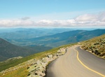
Drive White Mountain Trail, New Hampshire
The White Mountain Trail is a National Scenic Byway in the U.S. state of New Hampshire. The White Mountain Trail was designated on June 9, 1998 and is approximately 100 miles (160 km) long. Despite the name, it is a scenic byway accessible by car and not a hiking trail. It travels through the heart of the White Mountains crossing three major mountain passes. The Trail... -
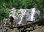
Hike to Whiteoak Canyon Falls & Pools, Shenandoah National Park, Virginia
This challenging hike in Whiteoak Canyon has a series of six waterfalls, the first (and tallest) is 86 feet (28 m). Not all the falls are easily accessible from the trail. It has been popular since the early days of Skyland Resort. Start at the lowest and work your way up to the tallest waterfall. You'll find a lot of cool places which you cannot see from the trail. ... -
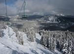
Ski or Snowboard White Pass Ski Area, Washington
The White Pass Ski Area is a ski area at White Pass, Washington, located 50 miles (80 km) west of Yakima on US-12, and 110 miles (180 km) east of Tacoma. The base elevation of White Pass is at 4,500 feet (1,370 m) above sea level, with a lift-served summit at 6,500 feet (1,980 m), yielding a vertical drop of 2,000 feet (610 m). Located on the south side of the east-we... -
Surf White Plains Beach, Oahu, Hawaii
White Plains Beach, on the west side of Oahu, offers A-frame waves that surfers can catch going left, right or straight toward the beach. The inside break features a sandy bottom, a nice thing for begineers so falls aren’t likely to end with cuts and bruises from the reef. -
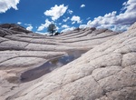
Off-road & Hike to White Pocket, Arizona
White Pocket is located on the Paria Plateau in Northern Arizona in Vermilion Cliffs National Monument. Visit this area if you can't get a permit to visit The Wave. It can only be reached by four-wheel-drive car. Once there, visitors encounter towering coral pink sand dunes. Beautiful colors of red, gold and white swirling in unique rock formations. It's about 2.5 h... -
Mountain Bike White Ridge Bike Trails, Ojito Wilderness, New Mexico
Tucked away in rugged and scenic country southwest of the community of San Ysidro, New Mexico, is the White Ridge Bike Trails Area. Just to the west is the newly designated Ojito Wilderness. Both sites are a short distance from U.S. 550. This region is known for its geological, cultural and paleontological resources, as well as for its scenic qualities. The bike trail... -
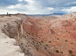
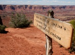
Hike to White Rim Overlook, Canyonlands National Park, Utah
The 1.8-mile (2.8 km) round trip hike to White Rim Overlook in Canyonlands National Park offers sweeping 300-degree views of the Colorado River, Monument Basin, and La Sal Mountains. Very limited trailhead parking. -
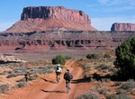
Off-road or Mountain Bike White Rim Road, Canyonlands National Park
The 100-mile White Rim Road loops in Canyonlands National Park in Utah usually take two to three days by four-wheel-drive vehicle or three to four days by mountain bike. When the weather is good the road is considered moderately difficult for high-clearance, four-wheel-drive vehicles. The steep, exposed sections of the Shafer Trail, Lathrop Canyon Road, Murphy's Hogb...

Price: $606.00