Give us feedback!


 See all

Our philosophy is simple. We want to encourage you to dream. BIG! Then we help you plan your trip, get the most out of it while you're traveling and help you share your experience with friends.
Join Now It's FREE
Dream Packages
Duration: 6 days
Price: $606.00
Price: $606.00
Duration: 2 days
Price: $242.00
Price: $242.00
Duration: 8 hours
Price: $208.72
Price: $208.72
Duration: 8 hours
Price: $220.83
Price: $220.83
Dreams Still To Do
Checked-Off Dreams
Dreams Still To Do
Checked-Off Dreams
Advertisement
Explore Adventure Sports
-
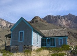
Off-road to Williams Ranch, Guadalupe Mountains National Park, Texas
To access Williams Ranch, check out a gate key at the Headquarters Visitor Center (Pine Springs). Only 4X4, high ground clearance vehicles are allowed along this rough, one-lane, dirt road. From Pine Springs drive west on highway 62/180 for 8.3 miles to a brown metal gate off the north side of the highway. The gate has a National Park Service arrowhead logo and an AT&... -
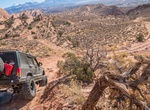
Off-road to Willie Boy Memorial Site, Landers, California
The Wests Last Famous Manhunt. Paiute Native American outlaw Willie Boy, who escapes with his lover, Lola, after killing her father in self defense. According to tribal custom Willie can then claim Lola as his wife. According to the law, Deputy Sheriff Cooper is required to charge him with murder. Willie Boy and Lola are hunted for several days by a posse led by Coope... -
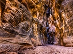
Hike Willis Creek Slot Canyon, Utah
Willis Creek is located in Grand Staircase-Escalante National Monument in southern Utah. The creek runs through a wash which in some sections narrows to become a slot canyon. The creek is popular with hikers as the stream is generally 1-2 inches deep and a trail runs the length of the creek. The end of the creek is dry. Use Skutumpah Road, also known as BLM 500, to ge... -
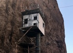
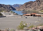
See Willow Beach Gauging Station, Cable Tramway & Catwalk, Black Canyon, Nevada & Arizona
What is a gauging station? In this case, it was a station that measured the flow of the Colorado River in the canyon below the Hoover Dam--and it’s pretty cool to see. Originally, this station consisted of two gauging stations, both on the Nevada side of the Colorado River, connected by bucket tramway cars hanging from cables across the river. These met on the A... -
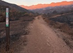
Visit Willow Beach (Lake Mohave), Arizona
This sandy beach is a beauty and offers plenty to do, with a full-service marina, fish hatchery, river trips and more. Enjoy the multicolored cliffs as you relax in the sand before taking a dip, renting a kayak, fishing or even going for a boat ride. Willow Beach is located 14 miles south of Hoover Dam off of U.S. 93, on the Arizona side of the water trail. Ameniti... -
Visit Willow Beach National Fish Hatchery, Arizona
The Willow Beach National Fish Hatchery is administered by the U.S. Fish and Wildlife Service, and was constructed in 1959 to take advantage of the cold water flowing from Hoover Dam and raise rainbow trout. The hatchery stocked as many as 175,000 Rainbow trout per year at Willow Beach, below Davis Dam and and in waters on tribal lands along the Colorado river. In 201... -
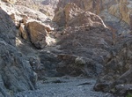
Hike Willow Canyon, Death Valley National Park, California
Willow Canyon trail is a 4.2 miles (6.8km) out and back hike in Death Valley National Park. route isn't very physically demanding, but finding the canyon and seasonal waterfall is a reward that only cross country navigators get to enjoy. No road and no hiking route signage. From the parking area avoid the small foothills and canyons to the east. Instead make your way ... -
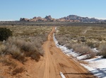
Off-road or Mountain Bike Willow Flats Road, Arches National Park, Utah
Offroad or mountain bike Willow Flats Road (BLM 378) in Arches National Park connects Hwy 191 with Willow springs Road and then Arches Scenic Drive. The Courthouse Wash crossing is often impassable. The trail is best used from March until September. -
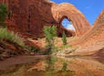
Hike Willow Gulch to Broken Bow Arch, Utah
The spectacular Broken Bow Arch is located in Willow Gulch in Utah. Hike approximately one mile downstream from the Willow Gulch trailhead off Hole-in-the-Rock Road. It is named after a Native American artifact found nearby. The opening is estimated at 94 feet (29 m) wide and 100 feet (30 m) high, demonstrating the arch-forming ability of Navajo sandstone. -
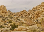
Hike to Willow Hole, Joshua Tree National Park
Willow Hole is a tiny oasis amid fantastic rock formations in Wonderland of Rocks. It's reached via 7-mile roundtrip hike from the Boy Scout Trailhead. Mostly flat trail along the edge of the Wonderland of Rocks. Travel through Joshua tree forests, boulder landscape, and sandy washes. Trail ends at willow trees. -
Off-road or Mountain Bike Willow Springs Trail, Herdina Park Section, Arches National Park, Utah
Herdina Park Section is located on the western side of Arches National Park in Utah that requires high-clearance 4×4. There are not too many arches in the area but it's still a great place to explore its secluded fins and canyons. Leaping Arch and Eye of the Whale Arch are must sees. The Willow Springs dirt road is less traveled than the paved roads, but they a... -
Hike Wills-Rice Loop at Ventura River Preserve, Ojai, California
Ventura River Preserve, Wills-Rice Loop is about 5.2 miles long and located near Ojai, California. The trail is great for hiking and normally takes two or three hours. The Ventura River Preserve is maintained by the Ojai Valley Land Conservancy. It contains a vast network of trails along the Ventura River and into the adjoining foothills. One can choose between easy, ... -
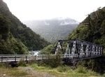
Hike Wills Valley Track, Mount Aspiring National Park, New Zealand
This track is for experienced trampers and starts at the Gates of Haast Bridge. Like most of the smaller valleys in this area, the Wills’ lower reaches are gorged, and then open out to flats further up. -
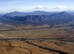
Explore Wilpena Pound, South Australia
Wilpena Pound is a natural amphitheatre of mountains located 429 kilometres (267 mi) north of Adelaide, South Australia, Australia in the heart of the Flinders Ranges National Park. The Pound is the most northern point with access via a sealed road in this part of the Flinders Ranges. The closest town to the north is Blinman and to the south, Hawker. The Pound is a ve... -
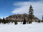
See Wilson Butte, Mammoth Lakes, California
Wilson Butte is a 8,405 ft / 2,562 m lava dome located north of Mammoth Lakes, California along Hwy 395. The lava dome is composed of gray rhyolite, frothy pumice, and black obsidian. There is no designated trail to the top.

Price: $120.43