Give us feedback!


 See all

Our philosophy is simple. We want to encourage you to dream. BIG! Then we help you plan your trip, get the most out of it while you're traveling and help you share your experience with friends.
Join Now It's FREE
Dream Packages
Duration: 6 days
Price: $606.00
Price: $606.00
Duration: 7 hours
Price: $179.00
Price: $179.00
Duration: 8 hours
Price: $208.72
Price: $208.72
Duration: 8 hours
Price: $220.83
Price: $220.83
Dreams Still To Do
Checked-Off Dreams
Dreams Still To Do
Checked-Off Dreams
Advertisement
Explore Adventure Sports
-
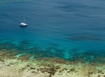
Dive Yasawa Reefs, Fiji
Yasawa Island is a remote island in Fiji and is made up of rugged volcanic rock whose sheer cliffs fall into the sea creating the most amazing limestone coral formations and drops offs. The island is surrounded by uncharted reefs, submerged in turquoise and jade green seas. The western side of the island (where the resort is located) is surrounded by magnificent, uns... -
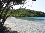
Hike Yawzai Point Trail, St John, USVI
Yawzai Point Trail starts just off Little Lameshur Bay on St John and heads out to Yawzai Point, a great snorkeling spot. -
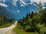
Drive Yellowhead Highway, Canada
The Yellowhead Highway is a major east-west highway connecting the four western Canadian provinces of British Columbia, Alberta, Saskatchewan, and Manitoba. Although part of the Trans-Canada Highway and the larger National Highway System, the highway should not be confused with the more southerly, originally-designated Trans-Canada Highway. The highway was officially ... -
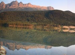
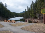
Explore Yellowhead Lake, BC, Canada
Yellowhead Lake is an irregularly shaped lake that is located about 3.7 km southwest of Yellowhead Pass within the boundaries of Mount Robson Provincial Park. It is on the lower reaches ofYellowhead Creek, a large creek that flows into the upper Fraser River above Moose Lake. Yellowhead Lake is a very odd shaped lake. It is about 5.6 km long & its width varies dep... -
Drive Yellowhead Pass, Canada
The Yellowhead Pass is a mountain pass across the Continental Divide of the Americas in the Canadian Rockies. It is located on the provincial boundary between the Canadian provinces of Alberta and British Columbia, and lies within Jasper National Park and Mount Robson Provincial Park. Due to its modest elevation of 1,131 m (3,711 ft) and its gradual approaches, the pa... -
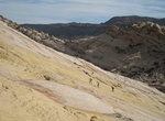
Hike Yellow Rock, Grand Staircase-Escalante National Monument, Utah
Yellow Rock Trail starts at the Hackberry Canyon trailhead and involves a steep climb up a near-vertical scree slope — challenging going up, scary coming down. From the Hackberry Canyon trailhead walk south down Cottonwood Creek. About 0.4 miles along the white cliffsthere will be a small drainage on the right. A cairn marks the entrance into the drainage. Atop ... -
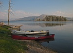
Kayak or Fish Yellowstone Lake, Yellowstone National Park
Yellowstone Lake is the largest body of water in Yellowstone National Park. The lake is 7,732 feet (2,357 m) above sea level and covers 136 square miles (350 km2) with 110 miles (180 km) of shoreline. While the average depth of the lake is 139 ft (42 m), its greatest depth is at least 390 ft (120 m). Yellowstone Lake is the largest freshwater lake above 7,000 ft (2,10... -
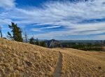
Hike Yellowstone Lake Overlook Trail, Yellowstone National Park, Wyoming
The trail begins at a trailhead marker near the entrance to the West Thumb Geyser Basin parking area and climbs through burned forest and a mountain meadow to a commanding view of Yellowstone Lake and the Absaroka Mountains. This trail is mostly level, with a moderately strenuous 400 foot (121 m) elevation gain near the overlook. Caution:Hydrothermal Area. Stay on de... -
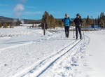
Ski & Snowshoe Yellowstone National Park, Wyoming
Yellowstone has miles of trails for the adventurous skier and snowshoer. Though track is set only on a few trails, all unplowed roads and trails are open to cross country skiing and showshoeing. Whether you are skiing a groomed trail in a developed area or venturing into the backcountry, remember that you are traveling in wilderness with all its dangers: unp... -
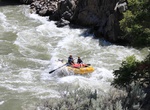
Float or Whitewater Raft Yellowstone River, Yellowstone National Park, Montana & Wyoming
Floating or whitewater rafting on the Yellowstone River is perfect for families and kids of all ages. The 8 miles of the beautiful Yellowstone River has Class II, III and even a Class IV depending on the time of the year. -
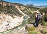
Hike Yellowstone River Overlook Trail, Yellowstone National Park, Wyoming
Begin at the Yellowstone River Picnic area, 1.25 miles (2 km) northeast of Tower Junction on the Northeast Entrance Road. The trail climbs steeply to the east rim of the Narrows of the Yellowstone River and then follows the rim. Return the same way or make a loop by continuing to the next trail junction, where you need to turn left and descend to the road. (... -
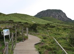
Hike Yeongsil trail, Hallasan National Park, Jeju Island, South Korea
Yeongsil Trail (5.8 km) starts from Yeongsil Management Office (altitude 1.000 m) to South cliff junction. It takes about 3 hours 15 minutes for a one way trip. -
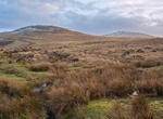
Summit Yes Tor, South West England
Yes Tor /ˈjɛs/ is the second highest point on Dartmoor, Devon, South West England, at 619 metres (2,031 ft) above sea level. It is one of only two wholly English peaks south of the Peak District National Park—the other being nearby High Willhays—that are above 2,000 feet (610 m). It lies within a British Army firing range and safe access is only possible o... -
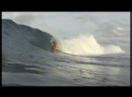
Surf Yin Yang, Maldives
Ying Yang is a powerful righthander and also the most consistent wave in the Laamu Atoll area. -
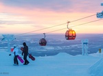
Ski or Snowboard Ylläs, Finland
Ylläs, or Yllästunturi in Finnish, is a 718-metre (2,356 ft) high fell in the municipality of Kolari in Lapland Province of Finland. There are two villages near Ylläs: Äkäslompolo on the north side and Ylläsjärvi in the south. They are connected by an 11 km road, around the side of the fell. Both villages derive much of their income ...
Price: $106.33