Give us feedback!


 See all

Our philosophy is simple. We want to encourage you to dream. BIG! Then we help you plan your trip, get the most out of it while you're traveling and help you share your experience with friends.
Join Now It's FREE
Dream Packages
Duration: 3 hours
Price: $140.24
Price: $140.24
Duration: 2 days
Price: $469.00
Price: $469.00
Duration: 7 hours
Price: $179.00
Price: $179.00
Duration: 3 hours
Price: $173.83
Price: $173.83
Dreams Still To Do
Checked-Off Dreams
Dreams Still To Do
Checked-Off Dreams
Advertisement
Explore Adventure Sports
-
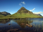
Summit Buachaille Etive Beag, Scottish Highlands, Scotland
Buachaille Etive Beag, is a mountain located between Glen Coe and Glen Etive, on the edge of Rannoch Moor in the Scottish Highlands. Viewed from the south in Glen Etive it forms a twin with Buachaille Etive Mòr (the 'Great Herdsman of Etive'), from which it is separated by a bealach at a height of about 480 metres. The mountain is often known affectionately as ... -
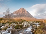
Summit Buachaille Etive Mòr, Scotland
Buachaille Etive Mòr (Scottish Gaelic:Buachaille Eite Mòr, meaning "the great herdsman of Etive"), generally known to climbers simply asThe Buachaille or The Beuckle, is a mountain at the head of Glen Etive in the Highlands of Scotland. Its pyramidal form, as seen from the A82 road when travelling towards Glen Coe, makes it one of the most recognisable m... -
Play Bubble Bump Football/Soccer
Bubble football or bubble soccer is the recreation or sport of playing football whilst encased in an inflated torus, similar to a zorb, which covers the player’s upper-body and head. The game is usually played indoors in a sports hall, or outdoors on grass or AstroTurf. The sport is becoming increasingly popular, with many people all over the world taking it up.... -
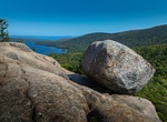
Hike to Bubble Rock, Acadia National Park, Maine
Climb The Bubbles to the park's iconic Bubble Rock, a carefully balanced giant boulder that lots of people take photo ops of them trying to push it off the mountain. -
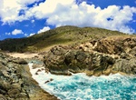
Hike to Bubbly Pool, Jost Van Dyke Island, BVI
Bubbling Pool (Bubbly Pool) on Jost Van Dyke Island in the BVI's is an interesting nature walk and a cool place to visit. The short 15 minute hike starts at Foxy's Taboo. Don't go when the tides are low since the water level will be low you will miss see the "bubbly" aspect of the pool. The best time of year is the winterwhen the north swell is good. WARNING: The pool... -
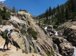
Hike Bubb's Creek Trail, Kings Canyon National Park, California
Bubb's Creek Trail is a 12.3 mile (19.8 km) trail starting at a steep, then steady, incline. The first campsite is after 4 miles (6.4 km) at Sphinx Creek Junction. -
Explore Buccaneer Bay Provincial Park, British Columbia, Canada
Buccaneer Bay Provincial Park is a provincial park in British Columbia, Canada, located 17 km west of Sechelt on North Thormanby Island, offshore from the community of Halfmoon Bay. -
Hike Buck Cove Mountain Trail, Schoodic Peninsula, Acadia National Park, Maine
Buck Cove Mountain Trail is a moderate, 3.2 miles (5.1 km) trail in Schoodic Peninsula, Acadia National Park, Maine. Beginning near the group sites in Schoodic Woods, this trail passes through forests and highbush blueberries to summit Buck Cove Mountain and continue up the north face of Schoodic Head. -
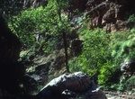
Hike Buck Farm Canyon, Colorado River, Grand Canyon, Arizona
Buck Farm Canyon is at Colorado River river mile 41 on river right. The canyon is along perennial creek and get narrow. There is some minor scrambling through some boulders at the beginning of this hike. -
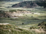
Hike Buck Hill Trail, Theodore Roosevelt National Park, North Dakota
You'll be on top of the world when you climb to the highest accessible point in the park. This is a short (0.2 mile), but steep trail. The view from the top is worth every step. -
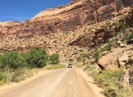
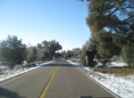
Off-road Buckhorn Draw Road, Utah
Buckhorn Draw Road (Buckhorn Wash Road) is the main route through the northern half of the San Rafael Swell. Sites include mines, old bridges and pictographs. -
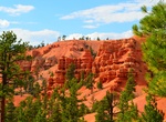
Hike Buckhorn Trail, Red Canyon, Utah
Buckhorn Trail #33037 extends into the scenic red rock terrain and takes you to a vantage point overlooking Red Canyon. This trail can be combined with the Goldenwall Trail and Red Canyon Bicycle Trail to make a nice five mile round trip. Castle Bridge Trail can be added to this combination, this would add a scenic side trail and a little more difficulty without addin... -
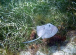
Dive or Snorkel Buck Island Reef National Monument (Chicken Island), USVI
Buck Island Reef National Monument, or just Chicken Island is a small, pink , 176 acre (712,000 m²) island about 1.5 miles (2.4 km) north of the northeast coast of Saint Croix, U.S. Virgin Islands. It was first established as a protected area by the U.S. Government in 1948, with the intention of preserving “one of the finest marine gardens in the Caribbean ... -
Drive Buckman Springs Road (S1), San Diego, California
County Route S1, also known as Sunrise Highway for a portion of its length, is a 34.08 mi (54.85 km) long county route located entirely in San Diego County, California. It begins at SR 94 near Barrett and moves northward across Interstate 8, just west of the Laguna Summit. This segment is also known as Buckman Springs Road. North of I-8, it is the Sunrise Scenic Byway... -
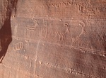
Hike to Buckskin Gulch Petroglyphs, Utah
The petroglyphs are located on the south (right) wall of Wire Pass just before the junction. Check the sky one last time because there is no exit from Buckskin Gulch until you reach the Middle Trail 6 1/2 miles down canyon. Hike down the flat bottom of Buckskin Gulch.

Price: $208.72