Give us feedback!


 See all

Our philosophy is simple. We want to encourage you to dream. BIG! Then we help you plan your trip, get the most out of it while you're traveling and help you share your experience with friends.
Join Now It's FREE
Dream Packages
Duration: 8 hours
Price: $83.37
Price: $83.37
Duration: 8 hours
Price: $208.72
Price: $208.72
Duration: 9 hours
Price: $109.14
Price: $109.14
Duration: 3 hours
Price: $140.24
Price: $140.24
Dreams Still To Do
Checked-Off Dreams
Dreams Still To Do
Checked-Off Dreams
Advertisement
Explore Adventure Sports
-
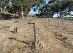
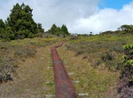
Hike Airport Loop Trail, Catalina, California
Airport Loop Trail, which reveals its main location in its name is a nice easy 2.3 mile loop trail around the airport. The trail offers sweeping views of both Black Jack Mountain and Mount Orizaba. The trail passes the location of the Native American soapstone quarry. It begins at the airport terminal. Buffalo Springs Reservoir is a small pond west of the airport run... -
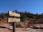
Hike Airport Loop Trails, Sedona, Arizona
The trail circles the upper slope of Airport Mesa (Table Top Mountain), described clockwise here. There is no shade until reaching the last mile where it is intermittent depending on season and time of day. From the parking area, climb to the southeast about 100 yards to the top of the small saddle. Turn right to pick up the trail which immediately bends to the left ... -
Go on Air Tour of Napali Coast, Kauai, Hawaii
Many of Kauai’s dramatic wilderness is accessible only by air, so take a helicopter or airplane ride over the Napali Coast and Kalalau Valley. There are several air tour companies on the island, like Blue Hawaiian Helicopters and Safari Helicopter Tours, which operate out of Lihue. Island Helicopters Hawaii is the only company that lands at Manawaiopuna Falls, ... -
See Ajanta Caves, India (UNESCO site)
The Ajanta Caves in Maharashtra, India are 31 rock-cut cave monuments which date from the 2nd century BCE. The caves include paintings and sculptures considered to be masterpieces of both Buddhist religious art (which depict the Jataka tales) as well as frescos which are reminiscent of the Sigiriya paintings in Sri Lanka. The caves were built in two phases starting ar... -
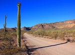
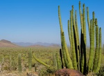
Drive or Mountain Bike Ajo Mountain Drive, Organ Pipe Cactus National Monument, Arizona
Ajo Mountain Drive is the most popular scenic drive in the monument. It is a 21 mile, mostly gravel road usually passable by normal passenger car. RVs over 24 feet are prohibited, due to the twisting and dipping nature of the road. The free Ajo Mountain Road Guidebook is available in the Kris Eggle Visitor Center. January through March a free three hour ranger guided... -
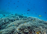
Dive Aka Island, Kerama Islands, Japan
Aka Island is an island in the Pacific Ocean and is part of the Kerama Islands group in Okinawa Prefecture, Japan. The island is commonly known as Aka or Aka-shima and is located some 15 miles to the southwest of Okinawa Island. It has a subtropical climate and a population of approximately 330 people. The water surrounding Aka-jima is supplied from the Kuroshio ... -
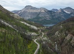
Drive or Bike Akamina Parkway, Waterton Lakes National Park, Alberta, Canada
The Akamina Parkway is a winding mountain road which starts in the Waterton townsite and runs 16 km along the Cameron Valley, ending at Cameron Lake. Along the way, stop at the national historic site commemorating Western Canada's first oil well. Crandell Lake, Lineham Falls, Rowe Lakes and Akamina Pass trailheads all are located along this road. Hiking and biking on ... -
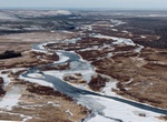
Explore Alagnak Wild River, Alaska
The Alagnak River is a 79-mile (127-kilometre) long river in Alaska. It has a catchment area of approximately 1400 square mi (3600 km²). It is located in central Lake and Peninsula Borough. In Yupik, the word "Alagnak" means "to err." Every year, the river changes its course and branches anew, for which reason it is sometimes called the "Branch River." The Alagna... -
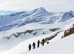
Ski or Snowboard Alagna Valsesia, Italy
Alagna Valsesia is a small village high in the Valsesia alpine valley in the province of Vercelli, Piedmont, Italy. It is located at the upper tip of Val Grande, in Piedmont Region of Italy, at an altitude of 1,191 m just south of the Monte Rosa 4638m (the second tallest peak in the Alps); it is a tourist site for mountaineering and winter sports, and is international... -
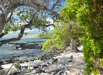
Hike Ala Kahakai National Historic Trail, Big Island, Hawaii
Ala Kahakai National Historic Trail is a 175-mile (282 km) long trail located on the island of Hawaiʻi. It is not yet a continuous "trail", but can be accessed at several broken segments along the coastline of the Big Island. The trail was established to access the traditional Ancient Hawaiian culture along with the natural geology of the island. The trail was establ... -
Hike Alakaʻi Swamp Trail, Kauai, Hawaii
The Alakaʻi Wilderness Preserve, popularly known as Alakaʻi Swamp, is a montane wet forest on the Hawaiian island of Kauaʻi. Although the preserve is home to alpine bogs, it is not a true swamp. It is located on a plateau near Mount Waiʻaleʻale, one of the wettest spots on Earth. The 3.5-mile (5.6 km) Alakaʻi Swamp trail is often shrouded in mist. This trail can be re... -
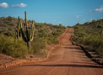
Hike Alamo Canyon Trail, Organ Pipe Cactus National Monument, Arizona
Alamo Canyon Trail is an easy 2 miles round trip. Recommended for birding. Footing can be rough. The trailhead is at Alamo Canyon Campground. -
Off-road Alamo Road, Nevada
The 70 mile Alamo Road goes through the Nevada desert. There is everything from a dry lake bed, to a deep rutted sandy muddy mess, to rough rocky mountains. Be careful of getting stuck at Desert Dry Lake. The playa dirt has turned to powder and conditions can be hazardous. Check here for current road conditions. Note: There is a gate at the end of this road and it... -
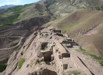
Hike to Alamut Castle Ruins, Gazor Khan, Iran
Alamut (meaning "eagle's nest") is a ruined mountain fortress located in the Alamut region in the South Caspian, near the village of Gazor Khan in Qazvin Province in Iran, approximately 200 km (130 mi) from present-day Tehran. In 1090 AD, the Alamut Castle, a mountain fortress in present-day Iran, came into the possession of Hassan-i Sabbah, a champion of th... -
Salmon Fishing in Alaska
The State of Alaska is an angler’s dream come true, famous for its prolific Salmon Fishing opportunities. The rivers and lakes of Alaska are teeming with fish every summer and the inlets and tidewater that lead to the ocean also provide waters rich with salmon. The Kenai Peninsula, stretching into the Gulf of Alaska with the capital city of Anchorage at its Nort...


Price: $120.43