Give us feedback!


 See all

Our philosophy is simple. We want to encourage you to dream. BIG! Then we help you plan your trip, get the most out of it while you're traveling and help you share your experience with friends.
Join Now It's FREE
Dream Packages
Duration: 7 hours
Price: $144.00
Price: $144.00
Duration: 8 hours
Price: $208.72
Price: $208.72
Duration: 2 days
Price: $242.00
Price: $242.00
Duration: 3 hours
Price: $173.83
Price: $173.83
Dreams Still To Do
Checked-Off Dreams
Dreams Still To Do
Checked-Off Dreams
Advertisement
Explore Adventure Sports
-
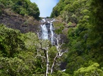
See Cascade de Tao, New Caledonia
Cascade de Tao is the highest waterfall (100 meters) in all of New Caledonia as well as the most impressive, plunging in two dramatic leaps with several sloping tiers. -
Swim at Cascade Falls, Litchfield National Park, Northern Territory, Australia
Cascade Falls is a great swimming holes in Litchfield National Park. A perfect place for a family day trip with nice picnic spots and breathtaking views. There are many rock pools, so if one is already being used, you can just move along to the next one. -
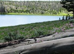
Hike to Cascade Lake, Yellowstone National Park, Wyoming
The Cascade Lake Trail joins the Cascade Creek Trail after 1.2 miles. if you begin on this trail, remember to bear left on your return trip. Either way, you will hike through forest and meadow to a pretty lake. Trailhead Option One:Cascade Lake Trailhead, 1.25 miles (2 km) north of Canyon Junction on the Grand Loop Road Trailhead Option Two:Cascade Creek Trailhead, ... -
Drive Cascade Lakes Scenic Byway, Oregon
The Cascades Lakes Scenic Byway (Forest Route 46) is a National Scenic Byway in central Oregon in the United States. It runs for 66 miles (106 km) in the rugged country of Deschutes and Klamath counties on the east side of the Cascade Range. It offers particularly good views of Mount Bachelor and provides access to many recreational facilities in central Oregon. The r... -
Summit Cascade Mountain, New York
Cascade Mountain is in Essex County of New York. It is one of the 46 Adirondack High Peaks and is located in the Adirondack Park. Its name comes from a series of waterfalls on a brook near the mountain's base. The lake it flows into and the pass between Cascade and Pitchoff mountains are also named Cascade. Cascade Mountain towers over the Van Hoevenberg ski center, t... -
Hike Cascade Pass to Sahale Arm Trail, North Cascades National Park, Washington
Cascade Pass is a 5,392-foot (1,643 m) mountain pass over the northern Cascade Range, east of Marblemount, Washington, U.S. Although an important pass, providing the easiest connection from the Cascade River to the head of Lake Chelan, it is now inside North Cascades National Park, and crossed by only a hiking trail. From the west, one reaches it by hiking an easy 3.5... -
Visit Cascades Picnic Area, Yosemite National Park, California
Cascades picnic area is located in the El Portal District near Cascades Creek. Picnic areas are available throughout Yosemite on a first-come, first-served basis (reservations are not available) from dawn to dusk. -
Hike Cascadilla Gorge Trail, Ithaca, New York
The Cascadilla Gorge Trail passes through the gorge of ancient bedrock past six waterfalls. -
Hike to Cascata do Salto do Prego & Cascata Salto do Cagarrão, São Miguel Island, Azores
Salto do Prego and Salto do Cagarrão are located in the parish of Faial da Terra, on the southwest coast of São Miguel Island, in the Azores. -
Dive or Snorkel Casino Point State Marine Conservation Area, Catalina Island, California
Casino Point State Marine Conservation Area(SMCAs) is a marine protected areas that include offshore, island marine habitat just outside of Avalon Harbor off the casino. The SMCAs cover .06 square miles. These SMCAs function essentially as dive areas in this popular diving and water sports area. The SMCAs protect marine life by limiting the removal of marine wildlife ... -
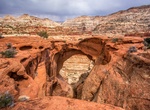
Hike to Cassidy Arch, Capitol Reef National Park
Named after the famous Butch Cassidy, Cassidy Arch is located in the central portion of Capitol Reef National Park along the Scenic Drive. The 1.7 mi (2.8 km) trail is a spur off of the larger Frying Pan Trail and is a great hike. -
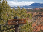
Hike or Ride Cassidy Trail, Red Canyon, Utah
Cassidy Trail #33093 begins at the Red Canyon Trailhead. This single track trail extends northerly to the ridge between Red Canyon and Losee Canyon; then northerly to the Casto Canyon Trail in Casto Canyon. The trail travels through spectacular red rock terrain and a variety of vegetation types including stands of old growth ponderosa pine. Special sites along the tra... -
Hike to Castello Barbarossa, Capri, Italy
Castello Barbarossa is an archaeological ruin and ornithological station in Anacapri, on the island of Capri, Italy. It derives its name from the pirate and Ottoman admiral, Hayreddin, nicknamed Barbarossa ("Redbeard"), who stormed it in 1535 and destroyed it in 1544. The construction date is uncertain but it perhaps dates back to the late ninth century. From 1898, th... -
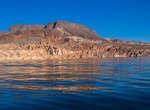
Kayak to Castle Cove, Lake Mead, Arizona
Located on the Arizona side of Lake Mead, this open-water paddle is normally mellow but can get tough when the wind comes up. Check conditions before your paddle! Distance: 8 miles round trip from Boulder Basin How to Get There: Drive to the Las Vegas Boat Harbor. Bring your own kayak or rent one from Las Vegas Boat Harbor. TIPS: It's an open-water paddle, so... -
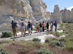
Off-road to Castle Gardens Petroglyph Site, Wyoming
The Castle Gardens Petroglyph Site is located in central Wyoming approximately 45 miles east of Riverton. The name of the area comes from the outcropping of sandstone which the wind has eroded into fanciful shapes resembling the turrets and towers of castle. This unusual formation has been luring visitors for thousands of years, and many of them left their mark in the...


Price: $106.33