Give us feedback!

Our philosophy is simple. We want to encourage you to dream. BIG! Then we help you plan your trip, get the most out of it while you're traveling and help you share your experience with friends.
Join Now It's FREE
Related Categories
Dreams Still To Do
Checked-Off Dreams
Dreams Still To Do
Checked-Off Dreams
Advertisement
Explore Viewpoints
-
See Battery 407, Diamond Head Crater, Oahu, Hawaii
Some modifications were also made about the time of World War II to the Diamond Head defences, most notably the addition of Battery 407 in 1943 through the crater wall on the south side. Battery 407 was constructed in 1943-1944 and the original plan was to mount guns salvaged from the USS Arizona. The mounts for the guns were prepared, but the guns were never installe... -
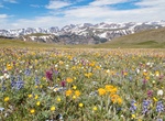
Explore Beartooth Pass, Wyoming
Beartooth Pass in Wyoming is at 10,947 feet (3,337 m) above sea level. Snowstorms can occur even in the middle of the summer at this altitude and the pass is also known for strong winds and severe thunderstorms. -
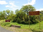
Visit Beaverhead Flat Overlook, Cornville, Arizona
Beaverhead Flat Overlook offers views of Verde Valley from this quiet vantage point. Located a few miles south of the Village of Oak Creek in Sedona, Arizona. Also a great place for nighttime stargazing! -
Visit Beenarourke Viewpoint, Ring of Kerry, Ireland
Beenarourke Viewpoint is along the Ring of Kerry, Co. Kerry, Ireland. -
Visit Beinisvørð, Faroe Islands
Beinisvørð is a 469 m high sea cliff in Suðuroy, Faroe Islands, the highest sea cliff in Suðuroy. It is located between the villages of Lopra and Sumba. Beinisvørð has vertical cliffs facing the sea and a green slope down towards the village of Sumba. The triangular top of Beinisvørð is visible from many places in Suðuroy, ... -
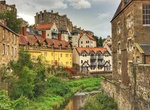
See View from Bell’s Brae Bridge, Dean Village, Edinburgh, Scotland
The Water of Leith Bridge at the foot of the steep roadways of Bell's Brae to the south leading to Edinburgh and Path Brae to the north leading to Granton and Queensferry, in the centre of Dean Village, is believed to be on the site of ancient crossings of the river. The current bridge was built in the early 18th century as a single arch bridge wide enough for a carri... -
See View from Belvedere Della Madonnina, Isola di Ponza, Italy
The top of Belvedere della Madonnina offers views of Le Forna and the Isola di Ponza coastline. -
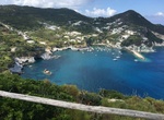
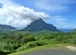
Visit Belvedere Lookout, Moorea, French Polynesia
Picturesque lookout point boasting striking views of mountains, Opunohu Bay, Cook's Bay & agricultural fields. -
Visit Benjakiti Park, Bangkok, Thailand
Benjakiti Park is a park in the Khlong Toei District of central Bankgkok; situated next to the Queen Sirikit National Convention Center. It is close to Queen Sirikit National Convention Centre MRT Station, Sukhumvit MRT Stationand Asok BTS Station. Benjakitti Park was developed from Tobacco pond area 200x800 meters, built by digging and reclamation. This park was part... -
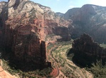
Visit Big Bend Viewpoint, Zion National Park, Utah
Big Bend is a breathtaking turn of the Virgin River in Zion National Park. The Great White Throne to the south. -
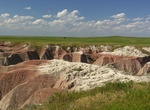
Visit Bigfoot Pass Overlook, Badlands National Park, South Dakota
Bigfoot Pass Overlook is on the north side of the Badlands Loop Road (Hwy 240) and provides a spectacular view of one of the major passes through the Badlands. Bigfoot Pass Overlook is a great place to capture sunset photos. -
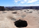
Hike Bighorn Overlook Trail, Dead Horse Point State Park, Utah
This is the longest spur off the West Rim Trail, branching off to the north from the vicinity of the campground. Because of its isolation (you may well be the only group on the trail) and the fact that its views rival those of Dead Horse Point itself, this trail can be considered a destination of its own. The overlook is named for an eroded fin that can be seen in the... -
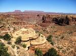
Visit Big Spring Canyon Overlook, Canyonlands National Park, Utah
Big Spring Canyon Overlook is located at the northern end of the Needle’s district of Canyonlands National Park, at the end of Route 211. -
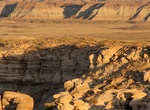
Hike to Billings Gap Overlook, Petrified Forest National Park, Arizona
The hike takes you to a great viewpoint of the Billings Gap area between Blue Mesa and the landform to the east. This hike follows the steep edge of Blue Mesa. -
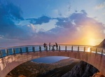
Visit Biokovo Skywalk, Makarska, Croatia
Glass-floored, horseshoe-shaped viewing deck on a mountain ridge, with panoramic sea views.