Give us feedback!


 See all

Our philosophy is simple. We want to encourage you to dream. BIG! Then we help you plan your trip, get the most out of it while you're traveling and help you share your experience with friends.
Join Now It's FREE
Dream Packages
Duration: 14 hours
Price: $450.00
Price: $450.00
Duration: 10 hours
Price: $102.74
Price: $102.74
Duration: 3 hours
Price: $140.53
Price: $140.53
Duration: 3 hours
Price: $118.81
Price: $118.81
Dreams Still To Do
Checked-Off Dreams
Dreams Still To Do
Checked-Off Dreams
Advertisement
Explore Ancient Art
-
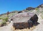
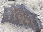
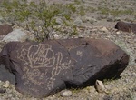
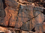
Visit Map Rock Petroglyphs Historic District, Canyon County, Idaho
Map Rock Petroglyphs Historic District in Canyon County, Idaho, is an archaeological site that includes petroglyphs believed to have been made by Northern Shoshone prior to contact with the 19th century Westward expansion of settlers in Idaho. The historic district is named for Map Rock, a massive basalt rock covered in petroglyphs, named by Robert Limbert in the earl... -
Explore Matobo National Park, Zimbabwe (UNESCO site)
The Matobo National Park forms the core of the Matobo or Matopos Hills, an area of granite kopjes and wooded valleys commencing some 35 kilometres south of Bulawayo, southern Zimbabwe. The Hills were formed over 2000 million years ago with granite being forced to the surface, this has eroded to produce smooth "whaleback dwalas" and broken kopjes, strewn with boulders ... -
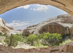
Hike to Maze Rock Art Site, Vermillion Cliffs National Monument, Arizona
The Maze Rock Art Site got its name from the petroglyph featured prominently on the main panel. Hike 0.5 miles east to view the petroglyphs. Created by the Anasazi people up to 700 years ago. -
See McConkie Ranch Petroglyphs, Vernal, Utah
McConkie Ranch Petroglyphs are located at 6228 McConkie Rd in Vernal, Utah. It's a short hile to the base of the cliffs. There are dozens of petroglyphs, many intricate and well-preserved. -
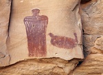
See McKee Springs Petroglyphs, Dinosaur National Monument, Utah
McKee Springs Petroglyphs are some of the finest large human-like designs in the area, as well as many other figures. They are located about 22 miles from the Quarry Visitor Center along the Island Park Road; road is impassible during wet weather - check road conditions before attempting to drive to this site. It's a short trail, with some elevation gain. -
Hike Mesa Point Trail, Petroglyph National Monument, New Mexico
The Mesa Point Trail is a short .4 mile lollipop loop in the Boca Negra Canyon section of Petroglyph National Monument. Located off of Unser Boulevard, ¼ mile north of Montaño Road, this canyon provides quick and easy access to three self-guided trails, (Mesa Point, Macaw, and Cliff Base) where you can view approximately 100 petroglyphs. Combined walkin... -
See Mesquite Spring Petroglyphs, Death Valley National Park
Mesquite Spring is located in the northernmost part of Death Valley. This part of the valley has numerous cotton top cactus, blister beetles and cholla cactus. On the alluvial fan above the springs there are 2-3 thousand year old petroglyphs from the extinct Mesquite Spring culture. The petroglyphs here are made possible because many of the rocks in these arid conditi... -
See Misool Islands Petroglyph, Misool Islands, Indonesia
Prehistoric petroglyph rock paintings in Raja Ampat, Southwest Papua, Indonesia. Aborigines from Australia left their markings in the form of rock paintings around Misool Island. 3,000 to 5,000 years. -
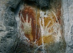
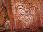
See Mitchell Falls Aboriginal Rock Art, Western Australia
Some rock art sites are along the track to the Mitchell Falls, including under the waterfall at Little Mertens Falls. Trail and park notes available at the start of the walk trail help to identify the rock art sites and their significance. -
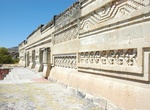
Visit Mitla, Mexico (UNESCO Site)
Mitla is the second most important archeological site in the state of Oaxaca in Mexico, and the most important of the Zapotec culture. The site is located 44 km from the city of Oaxaca. in the upper end of the Tlacolula Valley, one of the three that form the Central Valleys Region of the state. The archeological site is within the modern municipality of San Pablo Vill... -
Hike to Monarch Cave Ruins, Utah
Monarch Cave is a beautiful Anasazi cliff dwelling tucked high into an alcove above a shady desert pool of water along the Comb Ridge (Bulter Wash). Several interesting pictographs and petroglyphs line the nearby cliff walls. Take Lower Butler Washington Road (262) north from US Route 163 or south from Hwy 95 to reach the trailhead. -
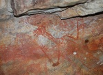
See Moqui Queen, Hog Canyon, Utah
Moqui Queen (aka Cleopatra Panel) is a Barrier style Pictograph that resides in a large alcove on the west side of SR 95 next to Hog Canyon, about 33 miles south of Hanksville, Utah. -
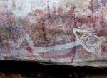
See Mount Borradaile Rock Art, Northern Territory, Australia
Rock art painted under a rock overhang near Mr Borradaile in Arnhem Land is thought to be the largest ever discovered in northern Australia. -
Explore Mount Chambers Gorge, Flinders Ranges, South Australia
Mount Chambers Gorge (alternative name: Marlawadinha Inbiri) is a gorge in the Australian state of South Australia in the locality of Wertaloona about 60 kilometres (37 mi) north-east of Blinman in the Flinders Ranges. Although on private land, they are a tourist attraction near to the road between Blinman and Balcanoona, Gammon Ranges National Park. They are part of ... -
See Mount Elizabeth Station Aboriginal Rock Art, The Kimberley, Western Australia
Mount Elizabeth Station is a pastoral lease that operates as a cattle station in Western Australia. It is situated about 205 kilometres (127 mi) north of Fitzroy Crossing and approximately 340 kilometres (211 mi) east of Derby just off the Gibb River Road in the Kimberley region. The abundant water supply and multiple food sources of the area enabled Aboriginal people...

Price: $242.00