Give us feedback!


 See all

Our philosophy is simple. We want to encourage you to dream. BIG! Then we help you plan your trip, get the most out of it while you're traveling and help you share your experience with friends.
Join Now It's FREE
Dream Packages
Duration: 12 hours
Price: $224.21
Price: $224.21
Duration: 10 hours
Price: $224.21
Price: $224.21
Duration: 3 hours 15 minutes
Price: $371.99
Price: $371.99
Duration: 4 days
Price: $663.61
Price: $663.61
Related Categories
- Australian National Parks & Reserves
- Canadian National Parks
- Canyoneering
- Day Hikes
- Guided Hikes
- In the Mountains
- Mountaineering
- Mountains
- New Zealand Great Walks
- New Zealand National Parks
- Parks & Reserves
- Rock Climbing
- South African National Parks
- UK National Parks
- UNESCO Parks & Preserves
- US Historical Parks (NHP)
Dreams Still To Do
Checked-Off Dreams
Dreams Still To Do
Checked-Off Dreams
Advertisement
Explore Hikes & Treks
-
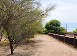
Hike Hardenberger Trail, Sonny Bono Salton Sea National Wildlife Refuge, Calipatria, California
The Michael Hardenberger Trail is located at Unit 1 off Vendel Road, which is at the south end of the Salton Sea. The .9 mile loop encircles one of our freshwater duck ponds with access to a photo blind. The trail includes both an observation deck and observation tower, which overlook the refuge’s marsh habitat and farmed winter foraging fields. This trail is be... -
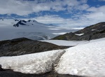
Hike Harding Icefield Trail, Kenai Fjords National Park, Alaska
The Harding Icefield is an expansive icefield located in the Kenai Mountains of the Kenai Peninsula in Alaska. It is also partially located in Kenai Fjords National Park. The 8.2-mile round trip Harding Icefield Trail is a strenuous and spectacular day hike. Starting on the valley floor, the trail winds through cottonwood and alder forests, passes though meadows fill... -
Do Hardrock 100 Mile Endurance Run, Colorado
The Hardrock Hundred Mile Endurance Run is an ultramarathon 100.5 miles (161.7 km) in length, with 33,000 feet (10,000 m) of climb at an average elevation of over 11,000 feet (3,400 m). The race is held on a loop course on 4WD roads, dirt trails, and cross country in Southern Colorado's San Juan Range, USA. The race is dedicated to the memory of the miners who settled... -
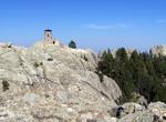
Summit Harney Peak, South Dakota
Harney Peak is the highest natural point in South Dakota and is located in the Black Elk Wilderness area, in southern Pennington County, in Black Hills National Forest. At 7,242 feet (2,207 m), it is also the highest summit in the United States east of the Rocky Mountains and the highest point in the Black Hills. The summit can be reached from Sylvan Lake, Camp Reming... -
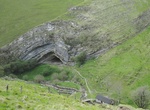
Hike to Harpea's Cave, France
Harpea's Cave (from the Basque "the place under the rock") is a cave located in Estérençuby, in the Navarre commune, a few meters from the Franco-Spanish border. It is an example of an anticline, a convex fold of strata, the centre of which is occupied by the oldest geological layers. -
Hike to Harper Cabin & Dams, Anza-Borrego Desert State Park, California
Harper Cabin & Dams are location deep in Anza-Borrego Desert State Park. The hike starts at the end of Pinyon Wash and starts up the narrow canyon. Harper Flat is reached at the end of the canyon. Stay close to the western edge and followed the wash up toward the south and along this canyon is the cabin and dams. The hike is about 5-7 miles (depends on on how... -
Hike Harper Canyon to Harper Flat, Anza-Borrego Desert State Park, California
The through Harper Canyon to Harper Flat in Anza-Borrego Desert State Park is about 9 miles out and back and takes abut 6 hours. The reward after a long canyon hike is coming out to one of Anza-Borrego’s most spacious valleys. Take Highway 78 east to mile 87.1 and turn south onto the dirt road leading to Harper Canyon and the “Cactus Garden.” At... -
Hike Harpers Corner Trail, Dinosaur National Monument, Colorado
Trail starts with a short descent but is then fairly level with a few moderate ups and downs. The end of the trail features an overlook with sweeping views of the river canyons with the Green River 2,500 feet (762 meters) below. -
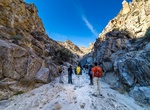
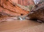
Hike to Harricane Wash to Coyote Gulch, Utah
Coyote Gulch is one of the most loved hiking destinations in southern Utah. The Hurricane Wash Trailhead is loacted at mile 33 on Hole-in-the-Rock Trail. Begin hiking East into the dry Hurricane Wash for 5.7 miles to reach Coyote Gulch. The hiker registration box is located 0.2 mile down the wash. It's 13 miles one-way from the Hurricane Wash Trailhead to Escalante R... -
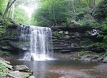
Hike to Harrison Wright Falls, Ricketts Glen State Park, Pennsylvania
Harrison Wright Falls, 27 feet (8.2 m), at Ricketts Glen State Park. It is the third of three named waterfalls on Kitchen Creek, south and downstream of Waters Meet. It is one of twenty two named waterfalls in the park, according to the Pennsylvania Department of Conservation and Natural Resources. -
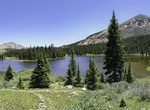
Hike to Hartenstein Lake, Colorado
A 6 mile round trip hike to Hartentstein Lake. Elevation 11,600ft. Total elevation gain 1,750ft. This trailhead is 12 miles west of Buena Vista along the Cottonwood trail. -
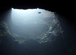
Hike to Harwoods Hole, New Zealand
At the end of Harwoods Hole Track is Harwoods Hole, the deepest vertical shaft (176 metres) in New Zealand. There is a 5.8 km out and back trail to the hole and takes about 45 minutes. A water-enlarged (but now dry) sinkhole, it drops to an underground river that emerges below and flows into Gorge Creek and then into the Takaka River. It is very dangerous to approac... -
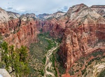
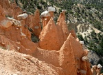
Hike Hat Shop Trail, Bryce Canyon National Park, Utah
The Hat Shop Trail is a down and back trail that begins at Bryce Point at the Peek-a-Boo Trailhead. It is not a loop. Walk down along the Under the Rim Trail to see a cluster of delicately balanced-rock hoodoos known as the Hat Shop. Although listed as a "Moderate" hike, the Hat Shop Trail should be listed as "Moderately Difficult". With a steep descent, visitors wi... -
Hike Hatterrall Hill, Wales
Hatterrall Hill is a rounded peak in the Black Mountains which sits on the Wales-England border, partly in Monmouthshire, Wales and partly in Herefordshire, England. Its summit at 531m is the high point of a peaty plateau which falls away steeply on all sides. Broad ridges run to the north, the southeast and southwest. To the north the ridge (known as Hatterrall Ridge... -
Summit Haupa‘Akea Peak, Maui, Hawaii
Haupa‘akea Peak is a mountain within Hawaii and is north of Pu‘uali‘i, southwest of Pu‘uopele and south of Kama‘oli‘i. Haupa‘akea Peak has an elevation of 9,147 feet.
Price: $606.00