Give us feedback!


 See all

Our philosophy is simple. We want to encourage you to dream. BIG! Then we help you plan your trip, get the most out of it while you're traveling and help you share your experience with friends.
Join Now It's FREE
Dream Packages
Duration: 8 hours
Price: $214.32
Price: $214.32
Duration: 12 hours
Price: $263.50
Price: $263.50
Duration: 10 hours
Price: $121.33
Price: $121.33
Duration: 12 hours
Price: $160.26
Price: $160.26
Related Categories
- Australian National Parks & Reserves
- Canadian National Parks
- Canyoneering
- Day Hikes
- Guided Hikes
- In the Mountains
- Mountaineering
- Mountains
- New Zealand Great Walks
- New Zealand National Parks
- Parks & Reserves
- Rock Climbing
- South African National Parks
- UK National Parks
- UNESCO Parks & Preserves
- US Historical Parks (NHP)
Dreams Still To Do
Checked-Off Dreams
Dreams Still To Do
Checked-Off Dreams
Advertisement
Explore Hikes & Treks
-
Hike Headquarters Canyon, Capitol Reef National Park, Utah
Headquarters Canyon is one of the few named hikes along the Waterpocket Fold in Capitol Reef National Park and is the closest drainage to The Post, once an important meeting point for ranchers. It's 1.3 miles up the north canyon and 1 mile up the south. To to both of the canyons; 3.6 miles round trip for both forks. Headquarters Canyon features sheer, vertical walls a... -
Trek or Mountain Bike Heaphy Track, New Zealand
The Heaphy Track is a popular tramping track in the north west of the South Island of New Zealand. It is located within the Kahurangi National Park and classified as one of New Zealand's nine Great Walks by the Department of Conservation. Named after Charles Heaphy, the track is 78.4 kilometres (48.7 mi) long and is usually walked in four or six days. The track runs f... -
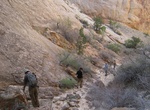
Canyoneer Heaps Canyon, Zion National Park, Utah
Heaps canyon in Zion is a big, huge technical slot canyon! Heaps and nearby Imlay canyons are unlike other canyons in Zion. What made Heaps and Imlay some of the most technically challenging canyons in Zion is instead of just one or two rappels, they have 20 to 30 apiece. Rating: 4B V R (v5a2 V) Rappels: 25, Max ↕290ft Heaps canyon has long exposures to water, diffi... -
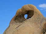
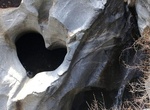
Hike to Heart Arch, Alabama Hills, Lone Pine, California
Heart Arch is located just off Movie Flat Road in the Alabama Hills near Lone Pine, California. -
Camp at Heart Lake, Olympic National Park, Washington
Heart Lake is located along the High Divide Loop Trail in Olympic National Park. There are 7 campsites and a toilet. -
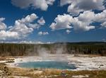
Hike to Heart Lake Geyser Basin, Yellowstone National Park, Wyoming
Heart Lake Geyser Basin is a small isolated basin that is mostly pools and vents of many different colors and forms, but also several geysers. The main features are Rustic Geyser and Columbia Pool, located at the far side of the basin beneath the reddish slopes of Mount Sheridan, and 7.5 miles from the nearest highway (the Grand Loop Road between the South Entrance an... -
Hike Heart Lake Trail, Yellowstone National Park, Wyoming
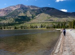
Heart Lake el. 7,461 feet (2,274 m) is a large backcountry lake, nestled at the base of Mount Sheridan in Yellowstone National Park. Heart Lake is in the Snake River drainage and is drained by the Heart River. The trail is a moderate hike through meadows and forests to Heart Lake and the Heart Lake Geyser Basin. Popular with anglers for Yellowstone cutthroat trout and... -
Hike Heart Lake Trail, Mammoth Lakes, California
The Heart Lake Trail is a favorite hiking route in the Mammoth Lakes Basin. From the Coldwater Campground Trailhead, take the Heart Lake trail on the eastern side of the parking area. Stay right on the trail as it passes small spurs that lead to the Consolidated Gold Mine. Trailhead elevation is 9,055 feet. In one-mile, you will see the heart-shaped lake, which is si... -
Hike to Heart of Farino, New Caledonia
The famous Heart of Farino. A heart shaped gap in the rock of a river bed. Great Fern Park, New Caledonia. -
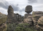
Hike Heart of Rocks Loop to Visitor Center, Chiricahua National Monument, Arizona
Heart of Rocks Loop Trail is a 7.3 miles (1.8 km) trail that combines the Ed Riggs, Mushroom Rock, Big Balanced Rock, Heart of Rocks Loop, Sarah Deming and Lower Rhyolite Canyon Trails. The trail is accessed from Massai Point or Echo Canyon Parking Lot. Make sure you have transportation back to your vehicle. Watch for changes in vegetation from the upper canyon area... -
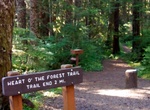
Hike Heart O' the Forest Trail, Olympic National Park, Washington
Heart O'the Forest Trail is 2.3 miles one way and starts at Loop E in Heart O’ the Hills campground. -
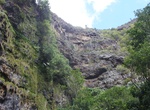
Hike to Heart Rock, Crestline, California
Heart Waterfall Hike is a nice easy trail for beginners with a great photo op at the heart rock and waterfall at the end of the hike. -
Hike to Heart Rock, Joshua Tree National Park
Heart Rock is located near White Tank Campground. Its about a half mile northeast of Arch Rock. It's hard to see until you get close. Day hikers cannot park at White Tank campground to get to Arch Rock or Heart Rock. Parking is across the street at 2 Tanks and start hike from there. -
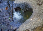
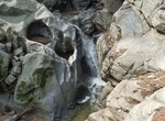
Hike Heart Rock Trail (Seely Creek Falls), Silverwood Lake State Recreation Area, California
Heart Rock Waterfall, which is also known as Seely Creek Falls, is located in Crestline, California. The waterfall has an almost perfect cut out of a heart right alongside it. -
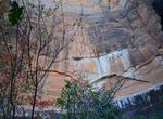
Hike to Heart Shaped Waterfall, Jamestown, Saint Helena Island
The hike to Heart Shaped Waterfall is through a rough muddy path - especially when it rains. But worth the effort. Water does not alwayys flow. The 90m waterfall runs mostly in the winter and early spring, fed by the winter rains. It's 1.6 km out and back from Barnes Rd.


Price: $1026.70