Give us feedback!


 See all

Our philosophy is simple. We want to encourage you to dream. BIG! Then we help you plan your trip, get the most out of it while you're traveling and help you share your experience with friends.
Join Now It's FREE
Dream Packages
Duration: 10 hours
Price: $224.21
Price: $224.21
Duration: 8 hours
Price: $214.32
Price: $214.32
Duration: 30 minutes
Price: $263.77
Price: $263.77
Duration: 4 days
Price: $1457.59
Price: $1457.59
Related Categories
- Australian National Parks & Reserves
- Canadian National Parks
- Canyoneering
- Day Hikes
- Guided Hikes
- In the Mountains
- Mountaineering
- Mountains
- New Zealand Great Walks
- New Zealand National Parks
- Parks & Reserves
- Rock Climbing
- South African National Parks
- UK National Parks
- UNESCO Parks & Preserves
- US Historical Parks (NHP)
Dreams Still To Do
Checked-Off Dreams
Dreams Still To Do
Checked-Off Dreams
Advertisement
Explore Hikes & Treks
-
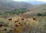
Explore Hollenbeck Canyon Wildlife Area, San Diego, California
Hollenbeck Canyon Wildlife Area is located near Jamul in California. The former cattle ranch was designated a wildlife area in 2001, and forms a wildlife corridor between Otay Mountain Wilderness and Jamul Mountains under the protection of the California Department of Fish and Wildlife. The area is open to the public for activities including hunting, equestrian use, h... -
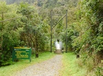
Trek Hollyford Track, New Zealand
The Hollyford Track is a tramping track in New Zealand. Located at the northern edge of Fiordland, in the southwestern South Island, it is unusual among Fiordland's major tracks in that it is largely flat and accessible year-round. It follows the Hollyford River which in turn follows the course of the Hollyford Valley. The track is 56 kilometres in length. It runs in ... -
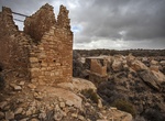
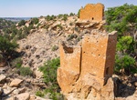
Hike to Holly Group, Hovenweep National Monument, Colorado
The Holly site is located down an unimproved dirt road that is 4 miles from the park visitor center (the same road as Horseshoe and Hackberry). High clearance and 4-wheel drive are strongly recommended. Stop by the visitor center for directions and road conditions. You can also hike to Holly from Hovenweep’s campground, located ¼ mile from the visitor cen... -
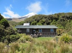
Hike to Holly Hut, Egmont National Park, New Zealand
A good day-long or overnight tramp with a few challenging sections. The track leads steeply uphill and passes below the Dieffenbach Cliffs. Further on it crosses the Boomerang Slip and heads past the Kokowai Track junction before descending to the Holly Hut turnoff. Holly Hut is 5 min from here. Be aware of the unbridged Minirapa Stream crossing just prior to the hut.... -
Hike Hollyridge Trail, Los Angles, California
Hollyridge Trail to Hollywood Sign Viewpoint is a 5.1 mile heavily trafficked out and back trail located near Universal City, California that offers the chance to see wildlife and is rated as moderate. The trail is primarily used for hiking, walking, running, and horses and is accessible year-round. Dogs are also able to use this trail but must be kept on leash. -
Hike Holly Trail from Campground, Hovenweep National Monument, Utah
This trail leads from Hovenweep’s campground to the Holly site through Keely Canyon. From the campground, follow the primitive trail through a slot canyon* to the canyon floor. The trail then follows along a wash, winding across it occasionally. About 2.5 miles in, the trail passes the rubble remains of a structure. The trail ascends through a second slot canyon... -
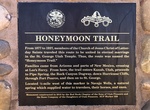
Hike Honeymoon Trail, Utah & Arizona
The Honeymoon Trail During the late 19th and early 20th centuries, a primitive wagon road was the principle travel route between the Mormon settlements in northeastern Arizona and southern Utah. In the late 1870s, Mormon colonists had been sent by church leaders to pioneer new settlements along Arizona’s Little Colorado River. As the new settlements were remote ... -
Hike to Honokōhau Beach via Ala Mauka-Makai Trail, Big Island, Hawaii
Honokōhau Beach on the Big Island of Hawaii is part of Kaloko-Honokōhau National Historical Park. Stretching north from Honokohau Boat Harbor, the striking white coral sand of Honokohau Beach contrasts sharply against the black lava. Numerous sea turtles frequent the beach to feed on the limu (algae) and bask along the shore. An ancient heiau (temple) stands at the e... -
Hike Hoodoo Trail, Ojito Wilderness, New Mexico
The Hoodoo Trail is a 3.4 mile out and back trail in the Ojito Wilderness. From Bernalillo, travel on U.S. 550 about 21 miles (about 2 miles before San Ysidro) turning left onto Cabezon Road (County Road 906). Follow the left fork approximately 9 and 1/4 miles to an Ojito Wilderness sign. Continue about 1 3/4 mile to a developed parking area on the left side of the r... -
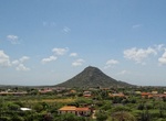
Summit Hooiberg (Haystack Mountain), Aruba
Hooiberg is a 165 m (541 ft) high volcanic formation on the island of Aruba. It is located almost in the center of the island and can be seen from virtually anywhere on the island. The haystack is in the center of the country and provides a breathtaking view of Aruba. People suggest going on a cool & clear day because it will be easier to climb the 561 steps requi... -
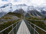
Hike Hooker Valley Track, New Zealand
The Hooker Valley Track is the most popular short walking track within the Aoraki/Mount Cook National Park in New Zealand. At only 5 kilometres (3.1 mi) length and gaining only about 100 m (330 ft) in height, the well formed track can be walked by tourists with a wide range of level of fitness. The track is maintained by the Department of Conservation and its main att... -
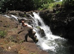
Hike to Ho'opi'i Falls, Kauai, Hawaii
Hoʻopiʻi Falls are a series of waterfalls along the Kapaʻa Stream, located near the Kapaʻa town on the east shore of Kauai. The 2.2-mile trail can be a bit tricky to find. The trailhead is at a dirt path guarded by an old metal gate covered in shrubbery. The falls were used as a filming location in Jurassic Park (1993) for the fictional site of the "Mano de Dios ... -
Hike Hoosier Hill, Franklin Township, Indiana
Hoosier Hill is the highest natural point in the state of Indiana at 1,257 feet (383 m) above sea level. It is in the rural area of Franklin Township, Wayne County to the northwest of Bethel. The nearest intersection to the high point is Elliot Road and County Line Road. The nearest major landmark is Interstate 70 and Richmond 11 miles (17.5 km) to the south. The Hill... -
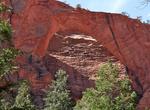
Hike to Hop Valley Trail to Kolob Arch, Zion National Park, Utah
The trail begins off the Kolob Terrace Road and wanders through the open fields with wide open views of the surrounding rock formations. As you near Hop Valley, the trail starts it's descent. The valley floor of Hop Valley is breathtaking with it's flat sandy bottom and vertical walls rising on both sides. The trail is sandy but well worn. The campsites are at th... -
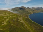
Hike Hornbjarg Cliffs, Hornstrandir Peninsula, Westfjords, Iceland
Hornbjarg Cliffs are enormous cliff at the remote northern tip of the Hornstrandir Nature Reserve in the Westfjörds


Price: $606.00