Give us feedback!


 See all

Our philosophy is simple. We want to encourage you to dream. BIG! Then we help you plan your trip, get the most out of it while you're traveling and help you share your experience with friends.
Join Now It's FREE
Dream Packages
Duration: 6 hours 30 minutes
Price: $167.71
Price: $167.71
Duration: 6 days
Price: $606.00
Price: $606.00
Duration: 12 hours 30 minutes
Price: $289.36
Price: $289.36
Duration: 10 hours
Price: $121.33
Price: $121.33
Related Categories
- Australian National Parks & Reserves
- Canadian National Parks
- Canyoneering
- Day Hikes
- Guided Hikes
- In the Mountains
- Mountaineering
- Mountains
- New Zealand Great Walks
- New Zealand National Parks
- Parks & Reserves
- Rock Climbing
- South African National Parks
- UK National Parks
- UNESCO Parks & Preserves
- US Historical Parks (NHP)
Dreams Still To Do
Checked-Off Dreams
Dreams Still To Do
Checked-Off Dreams
Advertisement
Explore Hikes & Treks
-
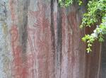
Hike to Hospital Rock, Sequoia National Park, California
Hospital Rock is a large quartzite rock in Sequoia National Park, located just off of the Generals Highway, on the Middle Fork of the Kaweah River. Hospital Rock was once home to 500 Potwisha Native Americans. Archaeological evidence shows settlement as early as 1350, and bedrock mortar sites and petroglyphs remain. The Native Americans mostly used this site in the wi... -
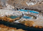
Hike to Hot Creek Geological Site, Mammoth Lakes, California
The trail to Hot Creek geological site is a unique place for dramatic Sierra views, a great half-day excursion from Mammoth Lakes in spring, summer or fall. Hot Creek Geological Site is a natural wonder located within the Long Valley Caldera, a geologically active area formed by a massive volcanic eruption approximately 760,000 years ago. The landscape stretches from ... -
Hike Hotel Creek Trail to Cedar Grove Overlook, Kings Canyon National Park, California
Hotel Creek TrailThe cool of the morning is the best time to hike this trail, which climbs up the relatively dry, south-facing side of the canyon. Cedar Grove OverlookThe trail switchbacks up through chaparral to a forested ridge and a rocky outcrop. This strenuous hike will reward you with a gorgeous view up and down Kings Canyon. A round trip of 5 miles with a 1200... -
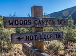
Hike Hot Loop Trail, Munds Mountain Wilderness, Arizona
The 10.4-mile (16.7 km) Hot Loop Trail runs generally north–south over Horse Mesa. Landmarks visible from vantage points along this trail include Bell Rock, Courthouse Butte, Sycamore Pass, and Woods Canyon. It meets up with Fire Service Road 9494F. Portions of this trail are hard to locate. No footpath is evident, you must follow rockpile cairns to find your wa... -
Hike Hot Loop Trail No. 94, Sedona, Arizona
Two things are hot about this trail. That's the way you'll feel when you complete the climb to the top of Horse Mesa and that's the way you'll describe the views when you get there. There's actually two ways to approach the Hot Loop, one is from a trailhead in Jacks Canyon near the Pine Flat Subdivision. The other is a trailhead in Woods Canyon off SR 179. From the J... -
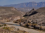
Hike Hot Springs Canyon Trail, Big Bend National Park, Texas
This 3 mile trail (either direction) connects Daniel's Ranch and the Hot Springs. In places, it runs close to the river; in other areas along the rim of Hot Springs Canyon. This trail offers beautiful views of the Rio Grande, Chisos Mountains, and Del Carmen Mountains. No shade makes this trail a challenge in summer heat. The trail begins at Daniel's Ranch or Hot Spr... -
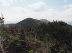
Summit Hough Peak, New York
Hough Peak (pronounced "huff") is a mountain located in Essex County, New York. The mountain, part of the Dix Range, is named after Franklin B. Hough (1822–1885), the first chief of the United States Division of Forestry, and sometimes called the "father of American forestry". Hough Peak is flanked to the north by Dix Mountain, and to the south by South Dix. The... -
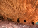
Hike to House on Fire Ruin on South Fork of Mule Canyon, Utah
The House on Fire Ruins are located on the South Fork of Mule Canyonat the southern end of Comb Ridge in Utah - just off Utah Hwy 95 about 20 miles southwest of Blanding. For the best photos arrive there in late morning when the light is reflecting off the opposite wall of the canyon. -
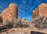
Hike to Hovenweep Castle, Hovenweep National Monument, Utah
Hiking to Hovenweep Castle along the Square Tower Loop Trail allows you to see the structures of Square Tower Group (some from a distance) within a shorter hike and without much elevation change. From the Canyon Overlook, follow the primitive Square Tower Loop Trail to the right (west) to Hovenweep Castle. Stay to the right at any trail intersections. At Hovenweep Cas... -
Climb Howling Ridge (Carrauntoohil), Ireland
Howling Ridge is known as one of Ireland’s classic and famous multi-pitch mountaineering routes. A steep, well defined ridge which cuts up the north-east face of Carrauntoohil. It is graded V. Diff in summer and goes at various grades in winter, depending on conditions. Howling Ridge starts at the loft... -
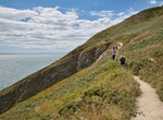
Hike Howth Cliff Walk, Howth, Ireland
Gentle clifftop hiking route overlooking a landmark lighthouse & bays, beaches & mountains. -
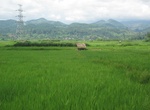
Trek around Hsipaw, Myanmar
The most popular trekking route from Hsipaw is to a Palaung village called Pan Kam, which can be visited in a day but is usually done as an overnight trip. It’s a 4–5 hour walk through fields and then uphill, starting at a Muslim cemetery on the western edge of Hsipaw and continuing through the villages of Nar Loy, Par Pheit, Nar Moon and Man Pyit. Pan Ka... -
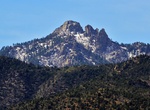
Summit Hualapai Peak, Arizona
Hualapai Peak is a 8,417-foot (2,566 m) summit in Mohave County, Arizona and is the highest point of the Hualapai Mountains. It is located about 15 miles (24 km) southeast of Kingman in Hualapai Mountain County Park. The mountain is characterized by huge granite outcroppings and pillars, a result of its volcanic origin. Although trails lead to its base, a moderate scr... -
Hike Huang Di Dian (Emperors Palace), Taiwan
Huang Di Dian or the "Emperors Palace" is one of the most popular and difficult trails for avid hikers in northern Taiwan. -
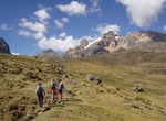
Trek Huayhuash Circuit, Peru
The Cordillera Huayhuash range in Peru has become noted for trekking in the form of the Huayhuash Circuit which is considered quite a challenge and is undoubtedly far more demanding than the famous Inca Trail in the south of Peru. Fewer people trek the Cordillera Huayhuash than the nearby Cordillera Blanca. The circuit generally takes between ten and fourteen days, de...

Price: $469.00