Give us feedback!


 See all

Our philosophy is simple. We want to encourage you to dream. BIG! Then we help you plan your trip, get the most out of it while you're traveling and help you share your experience with friends.
Join Now It's FREE
Dream Packages
Duration: 2 days
Price: $779.00
Price: $779.00
Duration: 6 to 10 hours
Price: $86.83
Price: $86.83
Duration: 4 days
Price: $1026.70
Price: $1026.70
Duration: 2 days
Price: $469.00
Price: $469.00
Related Categories
- Australian National Parks & Reserves
- Canadian National Parks
- Canyoneering
- Day Hikes
- Guided Hikes
- In the Mountains
- Mountaineering
- Mountains
- New Zealand Great Walks
- New Zealand National Parks
- Parks & Reserves
- Rock Climbing
- South African National Parks
- UK National Parks
- UNESCO Parks & Preserves
- US Historical Parks (NHP)
Dreams Still To Do
Checked-Off Dreams
Dreams Still To Do
Checked-Off Dreams
Advertisement
Explore Hikes & Treks
-
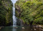
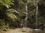
Walk to Kitekite Falls, New Zealand
Kitekite Falls (also called Kitakita Falls) is a scenic 3-tiered waterfall near Auckland, New Zealand. The falls drop a total of 40 metres (130 ft). From the lookout on Kitekite track the falls appear even higher because there is white water running over rocks into a small pool from the upper swimming hole, then falling down into a large pool, then falling to a small ... -
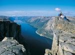
Hike Kjerag, Norway
Kjerag or Kiragg is a Norwegian mountain, located in Lysefjorden, in Forsand municipality, Ryfylke, Rogaland. Its highest point is 1110 m above sea level, but its northern drop to Lysefjorden attracts most visitors. The drop is 984 m (3,228 ft) and it is also the site of Kjeragbolten, a 5 m³ stone located between two rocks. Kjerag is a popular hiking destination.... -
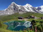
Hike Kleine Scheidegg, Switzerland
Kleine Scheidegg (elevation 2,061 m, 6,762 ft) is a high mountain pass below and between the Eiger and Lauberhorn peaks in the Bernese Oberland, Switzerland. It connects Grindelwald with Lauterbrunnen. In summer, it is a popular hiking destination, and is one of the passes crossed by the Alpine Pass Route. The Jungfrau Marathon, a mountain race that takes place every ... -
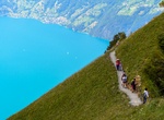
Hike Klingenstock to Fronalpstock (Stoos Ridge), Switzerland
Stoos Ridge hike between Klingenstock and Fronalpstockoffers phenomenal views of te Alps and 10 different mountain lakes. It's challenging enough for those looking for exercise, but not too hard. -
Hike to Klong Jark Waterfall & the Bat Cave, Ko Lanta, Thailand
The hike through The Jungle to Khlong Chak Waterfall & the Bat Cave is half an hour walk in the forest. During raining season it's very wet and the swimming in the waterfall is possible, in the dry season on the other hand there's not enough water. The Bat Cave is on the way to the waterfall so make sure not to miss it! -
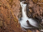
Hike to Klukkufoss, Snæfellsjökull National Park, Iceland
Klukkufoss ("Clock Falls") is a waterfall in Snæfellsjökull National Park. -
Hike Knife Edge at Mount Katahdin, Baxter State Park, Maine
Though you don’t need to cross the Knife Edge to summit 5,267-foot Katahdin, many Appalachian Trail’s thru-hikers can’t pass up the opportunity, often weaving it into their itineraries. At its narrowest, the mile-long arête between Katahdin’s west and east peaks squeezes down to less than 2 feet wide with 2,000-foot drops. -
Hike Knife Edge on Old Snowy Mountain, Goat Rocks Wilderness, Washington
The Knife Edge in Goat Rocks Wilderness is a section of the Pacific Crest Trail that teeters along Old Snowy in Washington’s Goat Rocks. It often gets top billing as the most dangerous stretch of the entire 2,650-mile PCT footpath. Crumbly, volcanic rock and patches of snow makes for sketchy footing. Start at the Snowgrass trailhead which links the Goat Ridge a... -
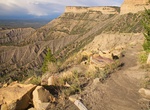
Hike or Snowshoe Knife Edge Trail, Mesa Verde National Park, Colorado
The trail follows a section of the old Knife Edge Road, from the northwest corner of Morefield Campground towards the Montezuma Valley Overlook. This trail provides good views of Montezuma Valley. Trail guide available. Built in 1914 as the main access into the park, old-timers still proudly talk about what a feat it was to build, or "hang," a road on this steep bluff... -
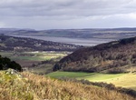
Hike to Knockfarrel Vitrified Fort, Strathpeffer, Scotland
Knockfarrel is a village, 1 mile east of Strathpeffer, in Dingwall in Ross-shire, Scottish Highlands and is in the Scottish council area of Highland. Knockfarrel or Knock Farrel, or indeed Knock Farril (stone fort) is a vitrified pictish Iron Age fort which lies on the knockfarrel hill, immediately to the north of the village, and which it gave its name to the village... -
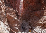
Canyoneer Knox Gorge, Karijini National Park, Western Australia
The initial hike in Knox Gorge is a 2km, 3 hour loop walk along the gorge.There are several pools along the way until you reach the "Gorge Risk Area" sign which marks the end of the journey if you did not bring canyoneering gear (and experience). A narrow steep 30m section goes until the bottom drops out which is the top of the Knox Slide. There are two decent option... -
Hike or Mountain Bike Kohekohe Track (Centennial Park at Campbells Bay), New Zealand
Centennial Park at Campbells Bay in New Zealand is near Auckland and is a popular recreational space which offers walking tracks and stunning harbour views. The Kohekohe track is a 40 minute loop up the right-hand side of the park and back down the gully. Dogs are allowed off-lead so take along your dog, especially in the summer when they are not allowed on the beach... -
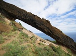
Hike to Koko Crater Arch, Oahu, Hawaii
Koko Crater Arch Trail starts from Halona Blowhole Lookout is a 0.9 mile loop trail. The trail is across lava rock and ends at an amazing natural arch with views of the Southeast side of Oahu. -
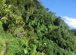
Hike Kokoda Track/Trail, Papua New Guinea
The Kokoda Trail or Track is a single-file foot thoroughfare that runs 96 kilometres (60 mi) overland — 60 kilometres (37 mi) in a straight line — through the Owen Stanley Range in Papua New Guinea. The track is the most famous in Papua New Guinea and is known for being the location of the World War II battle between Japanese and Australian forces in 1942.... -
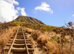
Hike Koko Head Railway Trail (Koko Crater Stairs), Oahu, Hawaii
During World War II, the US military built bunkers on top of Koko Crater with a railroad leading to its summit. In 1966, the air force ceded administration of Koko Crater over to the City of Honolulu. It was then renamed to the Koko Head Regional Park.[3] Within this park is the Koko Crater Trail, which is a 1.8-mile-long trail that uses the now-abandoned railroad as ...

Price: $214.32