Give us feedback!


 See all

Our philosophy is simple. We want to encourage you to dream. BIG! Then we help you plan your trip, get the most out of it while you're traveling and help you share your experience with friends.
Join Now It's FREE
Dream Packages
Duration: 10 hours
Price: $121.33
Price: $121.33
Duration: 4 hours
Price: $149.99
Price: $149.99
Duration: 6 days
Price: $606.00
Price: $606.00
Duration: 13 hours 30 minutes
Price: $572.77
Price: $572.77
Related Categories
- Australian National Parks & Reserves
- Canadian National Parks
- Canyoneering
- Day Hikes
- Guided Hikes
- In the Mountains
- Mountaineering
- Mountains
- New Zealand Great Walks
- New Zealand National Parks
- Parks & Reserves
- Rock Climbing
- South African National Parks
- UK National Parks
- UNESCO Parks & Preserves
- US Historical Parks (NHP)
Dreams Still To Do
Checked-Off Dreams
Dreams Still To Do
Checked-Off Dreams
Advertisement
Explore Hikes & Treks
-
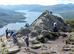
Summit Ben A'an, Loch Katrine, Scotland
Ben A'an is a hill in the Trossachs in Scotland. The pointed peak of its west top (454 metres or 1,490 feet in elevation) resembles a small mountain. Ben A'an is situated in the Trossachs area of the highlands north of Glasgow, rising above Loch Katrine and Loch Achray. The summit area is largely treeless and comprises several rock outcrops and crags, its highest poin... -
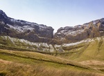
Explore Benbulbin (Ben Bulben), Ireland
Benbulbin, sometimes spelled Ben Bulben or Benbulben, is a large rock formation in County Sligo, Ireland. It is part of the Dartry Mountains, in an area sometimes called "Yeats Country". Benbulbin is an established climbing destination. If climbed by the north face, it is a dangerous climb. That side bears the brunt of the high winds and storms that come in from the A... -
Summit Ben Lawers, Scottish Highlands, Scotland
Ben Lawers (Scottish Gaelic:Beinn Labhair) is the highest mountain in the southern part of the Scottish Highlands. It lies to the north of Loch Tay, and is the highest point of a long ridge that includes seven Munros. It is the highest peak in Perthshire, and is the tenth highest Munro in Scotland. Ben Lawers was long thought to be over 4,000 feet (1,219.2 m) in heigh... -
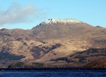
Summit Ben Lomond, Scotland
Ben Lomond (Scottish Gaelic: Beinn Laomainn, 'Beacon Mountain'), 974 metres (3,196 ft), is a distinctive mountain in the Scottish Highlands. Situated on the eastern shore of Loch Lomond, it is the most southerly of the Munros. Ben Lomond lies within the Ben Lomond National Memorial Park and the Loch Lomond and the Trossachs National Park, property of the National Trus... -
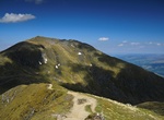
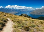
HIke Ben Lomond Walkway, Queenstown, New Zealand
The hike begins at Douglas fir on Skyline Access Road/Tiki Trail. At about 800m altitude, you enter alpine tussocks and shrubs, climbing to the 1326m Ben Lomond Saddle (Ben Lomond Station). The trail gets steeper and rougher as it approaches Ben Lomond's 1,748m summit. It takes 3-4 hours to Ben Lomond Saddle, 6-8 hours to Ben Lomond Summit With great weather you ... -
Summit Ben Macdui, Scotland
Ben Macdui is the second highest mountain in the United Kingdom after Ben Nevis, and the highest in the Cairngorms. After the defeat of Domnall mac Uilliam in 1187, Donnchad II, Earl of Fife, acquired Strathavon, territory stretching from Ballindalloch to Ben Macdui; because the mountain marked the western boundary of Donnchad's territory, historian and place-name sch... -
Summit Ben Nevis, Scotland
Ben Nevis (/ˈnɛvɪs/NEV-iss; Scottish Gaelic:Beinn Nibheis, Scottish Gaelic pronunciation: [pe(ɲ) ˈɲivɪʃ]) is the highest mountain in Scotland, the United Kingdom, and the British Isles. The summit is 1,345 metres (4,413 ft) above sea level and is the highest land in any direction for 739 kilometres (459 miles).[a] Ben Nevis stands at the western end of the Grampian Mo... -
Hike Benton MacKaye Trail (BMT), Georgia, Tennessee & North Carolina
The Benton MacKaye Trail or BMT is a footpath nearly 300 miles (480 km) in length in the Appalachian Mountains in the southeastern United States and is blazed by a white diamond, 5" across by 7" tall. It's a great way to see the beauty of the southern Appalachians without the crowds of the Appalachian Trail. A speedy and disciplined hiker could do the trail in two wee... -
Hike Benures Bay to Money Bay, Norman Island, BVI
Hike from the southeast end of Benures Bay over to Money Bay. -
Summit Ben Venue, Trossachs, Scotland
Ben Venue is a mountain in the Trossachs area of Scotland. The name Ben Venue is derived from the Scottish Gaelic words meaning "the miniature mountain". The summit lies approximately 2 kilometres south-west of the pier at the southern end of Loch Katrine. At the foot of the mountain close to the shore of Loch Katrine isBealach nam Bòmeaning the "pass of the ca... -
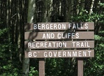
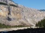
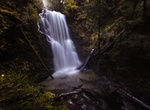
Hike to Bergeron Falls, Tumbler Ridge, BC, Canada
Bergeron Falls is the highest accessible waterfall in northern British Columbia at 330 feet in height A group out of Tumbler Ridge built a trail to the falls and expanded it over the years to include a metal bridge over Bergeron Creek above the falls. The hike is a moderate 8.8 km return to the top of the falls, or challenging 11.5 km for the circular route, which ta... -
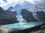
Camp at Berg Lake, Mount Robson Provincial Park, BC, Canada
Berg Lake is a lake on the Robson River just below the river's source located within Mount Robson Provincial Park, at the doorstep of the north face of Mount Robson, the highest peak in the Canadian Rockies. It is partly fed by the Berg Glacier. The turquoise colored Berg Lake is dotted with icebergs even in the middle of summer. Berg Lake Trail climbs gradually along... -
Hike Berg Lake Trail, Mount Robson Provincial Park, BC, Canada
Berg Lake is a lake on the Robson River just below the river's source located within Mount Robson Provincial Park, at the doorstep of the north face of Mount Robson, the highest peak in the Canadian Rockies. It is partly fed by the Berg Glacier. The Berg Lake Trail climbs gradually alongside the Robson River (a tributary of the Fraser River) for 4.2 kilometres (2.6 mi... -
Hike Berry Creek Falls Loop Trail, Big Basin Redwoods State Park, California
If you have a full day, head to Berry Creek Falls, a 10.5-mile roundtrip hike. Along the way, you’ll see huge coast redwoods and four spectacular waterfalls. Be prepared for a workout, too, with an elevation change of 2,150 feet. Trailhead is across the street from Park Headquarters, at the large Redwood Trail Marker, across Opal Creek from the Opal Creek Comfo... -
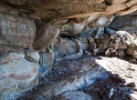
Hike to Bertie's Balcony, Silvermine Nature Reserve, Cape Town, South Africa
Bertie's Balcony is a 6.6 km out and back trail located in Silvermine Nature Reserve, Cape Town, South Africa.
Price: $160.26