Give us feedback!


 See all

Our philosophy is simple. We want to encourage you to dream. BIG! Then we help you plan your trip, get the most out of it while you're traveling and help you share your experience with friends.
Join Now It's FREE
Dream Packages
Duration: 4 days
Price: $1026.70
Price: $1026.70
Duration: 10 hours
Price: $121.33
Price: $121.33
Duration: 4 hours
Price: $129.99
Price: $129.99
Duration: 4 hours
Price: $129.99
Price: $129.99
Related Categories
- Australian National Parks & Reserves
- Canadian National Parks
- Canyoneering
- Day Hikes
- Guided Hikes
- In the Mountains
- Mountaineering
- Mountains
- New Zealand Great Walks
- New Zealand National Parks
- Parks & Reserves
- Rock Climbing
- South African National Parks
- UK National Parks
- UNESCO Parks & Preserves
- US Historical Parks (NHP)
Dreams Still To Do
Checked-Off Dreams
Dreams Still To Do
Checked-Off Dreams
Advertisement
Explore Hikes & Treks
-
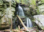
Hike Baskins Creek Falls Trail, Great Smoky Mountains National Park
Baskins Creek Falls Trail is a moderate 4.8 mile out and back trail off Roaring Fork Motor Trail in Great Smoky Mountains National Park. -
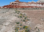
Explore Bat Canyon, Arizona
Bat Canyon is east of Ha Ho No Geh Canyon and is a tributary of Ha Ho No Geh Wash. The canyon is at an elevation of 5,892 feet or 1,795.8 meters. The canyon's name comes from the Native Americans of the area, who saw many bats near a local rock formation (Navajo: jaá abaní há atiin, "bat trail"). Blue Canyon, Coal Mine Canyon East, Ha Ho No Geh,... -
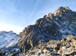
Summit Batian, Mount Kenya, Mount Kenya National Park, Kenya
At 17,057 ft., Batian is one of the highest peaks of Mount Kenya National Park’s eponymous mountain. About 50 climbers summit Batian each year. When ascended directly, Batian is usually climbed via the North Face Standard Route, UIAA grade IV+ (or 5.6+ YDS). The first recorded ascent of Batian was on 13 September 1899 by Sir Halford John Mackinder, Cesar... -
Hike Batiquitos Lagoon Trail, Carlsbad, California
The Batiquitos Lagoon Trail is easy and offers a great way to experience one of the few remaining tidal wetlands in Southern California. The Batiquitos Lagoon Trail is located off of Interstate 5 in Carlsbad. -
Hike Battle Road Trail, Massachusetts
The five-mile 4.6 mile "Battle Road Trail" connects historic sites from Meriam’s Corner in Concord to the eastern boundary of the park in Lexington. The main theme of the trail is the Battle of April 19, 1775, that launched the American Revolution. The trail includes a restored colonial landscape approximating the path of the running skirmishes between British t... -
Hike Baxter Pass Trail, John Muir Wilderness, California
The Baxter Pass Trail provides access to the John Muir Wilderness. It climbs more than 6,000 feet to Baxter Pass, on the Sierra Crest. The trail continues into Kings Canyon National Park, where it joins the John Muir Trail. Baxter Pass Trail is steep and rugged. In some places it is difficult to locate. The 10-mile loop takes you to the alpine basin of Summit Meadow. ... -
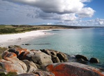
Hike Bay of Fires, Tasmania, Australia
Hike the remote landscape and breathtaking beaches along the East Coast of Tasmania exploring the Bay of Fires. This 16 miles, 4 days walk will be on soft sandy beaches, surreal rock formations and coves. The Bay of Fires walk is a four-day guided trip; you can’t do it solo (there is no water on the route). After a 5.5 mile walk on the first day you will arriv... -
Bike or Hike Bayshore Bikeway (Silver Strand Bikeway), Coronado, California
The Silver Stand is a long stretch of land from Coronado to Imperial Beach. There is a great bike bath along the entire length that is flat and smooth. The bike path starts from the ferry landing or in front of the Coronado Yatch Club and goes around the southern part of San Diego Bay. It's part of the longer 24 mile Bayshore bikeway that loops the bay and involves a ... -
Hike Bayside Trail (Cabrillo National Monument), San Diego, California
There are many short trails with fantastic views throughout Cabrillo National Monument (e.g. tidepool area, around the bunkers, whale lookout, and lighthouse) including the Bayside Trail. This trail is 2.5 miles (round-trip) with great views of the ocean, Ballast Point (where Cabrillo landed), downtown, Coronado Island, Tijuana, sandstone cliffs, ships, plant life, an... -
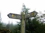
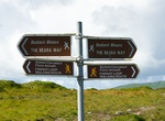
Hike Beacons Way, Brecon Beacons National Park, Wales
The Beacons Way is a waymarked long distance footpath in the Brecon Beacons National Park, Wales. It is a linear route which runs for 95 miles (153 km) east to west through the National Park, and passes many of the most important landmarks and mountain peaks in the mountain range. It also includes many of the towns in the park as well as popular attractions such as Ca... -
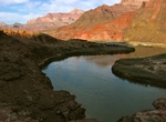
Hike Beamer Trail, Grand Canyon National Park, Arizona
The Beamer Trail is a backpacking trail located on the South Rim of the Grand Canyon National Park. The trail begins at the end of the Tanner Trail, at the confluence of Tanner Creek and the Colorado River. This confluence created the Unkar Creek Rapids. From here the trail follows the Colorado north (upstream) to its confluence with the Little Colorado River. Th... -
Hike Beara Way, Ireland
The Beara Way is a long-distance trail in Republic of Ireland. It is a 206-kilometre (128-mile) long circular trail around the Beara Peninsula that begins and ends in Glengarriff, County Cork. It is typically completed in nine days. It is designated as a National Waymarked Trail by the National Trails Office of the Irish Sports Council and is managed by the Beara Tour... -
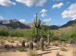
Hike Bear Canyon Trail to Seven Falls, Arizona
Bear Canyon, located in the Sabino Canyon recreation area of the Coronado National Forest near Tucson, Arizona, offers views of the Santa Catalina Mountains to the north. Accessible by tram or foot from the Sabino Canyon visitors' center, Bear Canyon contains such attractions as the seasonal Seven Falls and Thimble Peak. -
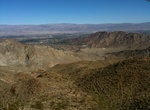
Hike Bear Creek Canyon Trail, La Quinta, California
The Bear Creek Canyon Trail is a strenuous if going all the way to the oasis at the end of the trail. The trail is 9 miles and 1,873 feet elevation gain. At the 4 mile mark there is a large oasis tucked into the end of the canyon. The trailhead is near the end of Eisenhower Drive in La Quinta. The trail also continues along the west wide of the city to where it merges... -
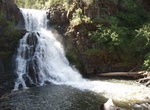
Hike to Bear Creek Falls, Payette National Forest, Idaho
Bear Creek is a tributary of Wildhorse River, which is a tributary of the Snake River. Access to the Falls is cross-country on extremely steep slopes. Rattlesnakes are a problem.


Price: $199.57