Give us feedback!


 See all

Our philosophy is simple. We want to encourage you to dream. BIG! Then we help you plan your trip, get the most out of it while you're traveling and help you share your experience with friends.
Join Now It's FREE
Dream Packages
Duration: 4 hours
Price: $149.99
Price: $149.99
Duration: 4 hours
Price: $129.99
Price: $129.99
Duration: 12 hours
Price: $263.50
Price: $263.50
Duration: 14 hours
Price: $341.00
Price: $341.00
Related Categories
- Australian National Parks & Reserves
- Canadian National Parks
- Canyoneering
- Day Hikes
- Guided Hikes
- In the Mountains
- Mountaineering
- Mountains
- New Zealand Great Walks
- New Zealand National Parks
- Parks & Reserves
- Rock Climbing
- South African National Parks
- UK National Parks
- UNESCO Parks & Preserves
- US Historical Parks (NHP)
Dreams Still To Do
Checked-Off Dreams
Dreams Still To Do
Checked-Off Dreams
Advertisement
Explore Hikes & Treks
-
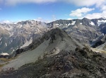
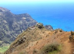
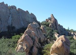
Summit Avalanche Peak, Arthur's Pass National Park, New Zealand
Avalanche Peak is a 1,833 metres (6,014 ft) peak in the in New Zealand. It is subject to avalanches in the winter, hence its name. It is the most popular day walking peak from Arthur's Pass, as it is easily accessible from the village and offers views of several mountain ranges in the park on a clear day. It is also a popular place for kea. Avalanche Peak is the only ... -
Summit Avalanche Peak, Yellowstone National Park, Wyoming
The hike to Avalanche Peak in Yellowstone National Park is a 4.2 mile out and back trail.It is a fun climb up a tall peak as you enter the park from the east. -
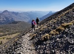
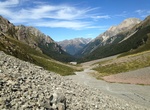
Hike Avalanche Peak - Crow River Route, Arthur's Pass National Park, New Zealand
This route makes a good weekend trip, all against a backdrop of some of the best features of Arthur’s Pass National Park – glaciers, mountain peaks and ice-fed rivers. Crow Hut is at the bush edge in an alpine meadow. The sections of the route are: Arthur's Pass village to Crow Hut Arthur's Pass village to Avalanche Peak (3–4 hours one way) A... -
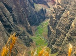
Hike Awa'awapuhi Trail, Kauai, Hawaii
The Awa'awapuhi Trail in Koke’e State Park is just off the highway 550 in Kauai. The hike is 6.2 miles out and back and takes 3-3.5 hours. The trail goes to the rim of Nualolo and Awa’awapuhi valleys. NOTE: The Nualolo Cliffs Trail is CLOSED due to dangerous conditions. The trail starts near the 3.0 mile point on the Awaawapuhi Trail and meets the Nuʻ... -
Hike Awaʻawapuhi Trail, Kauai, Hawaii
Awaʻawapuhi Trail offers mesic and dryland native plants. Spectacular view into steep-sided Nuʻalolo and Awaʻawapuhi Valleys. Return climb of 1,620 ft (490 m). -
Hike Aztec Butte Trail, Canyonlands National Park, Utah
The Aztec Butte Trail is a moderate 2 mile (3 km) hilke with a steep climb leading to ancestral Puebloan granaries and view of Taylor Canyon. Elevation change: 225 feet (68 m). -
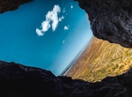
Hike to Aztec Caves, Franklin Mountains State Park, El Paso, Texas
The Aztec Cave Trail is a popular hike in Franklin Mountains State Park. The caves can be seen from the trailhead parking lot. From the trailhead the trail crosses an arroyo before beginning its gradual ascent, passing a couple of campsites along the way. Smoke on the ceiling of the cave and markings on the wall reflect the presence of humans over many years. -
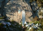
Hike to Aztec Falls, Lake Arrowhead, California
Aztec Falls in San Bernardino National Forest is a half-mile hike from the Pacific Crest Trail. The cliffs offer dives ranging from five to almost 60 feet high, with poolside stone slabs on which the less adventurous can sunbathe and spectate. Can hike the lower path and stay in the shallow water- requiireing some rock hopping and a few small swim spots that aren&rsqu... -
Hike to B-24 Liberator Crash Site at Fairy Lochs, Scotland
The Fairy Lochs is a recent English name forNa Lochan Sgeireachand are a small group of freshwater lochans approximately 2 mi (3.2 km) south-east of the village of Badachro, near Gairloch in Wester Ross, Scottish Highlands. The lochans have become known as the 'Fairy Lochs' due to their proximity to 'Sìthean Mòr' which translates as 'Big Fairy Hill'. Alt... -
Hike to B24 Liberator Crash Site (Guadalupe Peak), Guadalupe Mountains National Park, Texas
On the last day of 1943, a Consolidated B-24D left Biggs Field in El Paso, Texas, on an instrument training mission, and struck a hill west of Pine Top. The accident was attributed to icing, and all five members of the crew were killed. Extensive wreckage exists at the site today The B-24 is located in a remote location off the Bush Mountain Trail in the park's high ... -
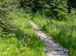
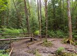
Hike to Babcock Falls, Tumbler Ridge, BC, Canada
A short trail leads through pine forests and wetlands to 8 metre high Babcock Falls. The wet sections have wooden boardwalks. Babcock Falls plunges over a cliff formed by a thick layer of coarse-grained sandstone and conglomerate. Rocks of this composition indicate that the sediments were laid down in a high-energy environment. Such an environment is unlikely to allow... -
Hike or Mountain Bike Backbone Trail, Santa Monica Mountains, California
The Backbone Trail is a long distance trail extending 67.79 miles (109.10 km) across the length of the Santa Monica Mountains in the U.S. state of California. Its western terminus is Point Mugu State Park and its eastern terminus is Will Rogers State Historic Park in Pacific Palisades. The trail is open to hikers throughout its length; dogs, mountain bicyclists and ho... -
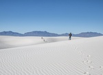
Hike Backcountry Camping Trail, White Sands National Monument, New Mexico
Are you looking for expansive views of snow-white gypsum dunes for miles? If so, this trail is for you. Hiking the Backcountry Camping Trail provides a sense of the magnitude of the world's largest gypsum dunefield while not having to venture too far from one's vehicle. The Backcountry Camping Trail is a moderate, 2-mile (3.5 km), round-trip hike. Though backpackers ... -
Hike Baden-Powell Trail, BC, Canada
The Baden-Powell Trail is a rugged but well-maintained trail that traverses Greater Vancouver's North Shore region. The trail is about forty-eight kilometres long, extending (west to east) from Horseshoe Bay in West Vancouver to Deep Cove in the District of North Vancouver. In between, the trail winds through the heavily forested North Shore Mountains. It also connect... -
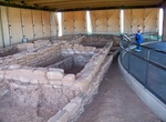
Hike Badger House Community Trail, Mesa Verde National Park, Colorado
Take the gravel trail south from the Wetherill Mesa Kiosk, pass the junction to Nordenskiöld Site #16 Trail and cross the paved Long House Loop to explore the 1-mile (1.6 km) loop through the Badger House Community—four excavated mesa top villages representing 600 years of Pueblo history.


Price: $779.00