Give us feedback!


 See all

Our philosophy is simple. We want to encourage you to dream. BIG! Then we help you plan your trip, get the most out of it while you're traveling and help you share your experience with friends.
Join Now It's FREE
Dream Packages
Duration: 4 hours
Price: $129.99
Price: $129.99
Duration: 12 hours
Price: $224.21
Price: $224.21
Duration: 12 hours 30 minutes
Price: $289.36
Price: $289.36
Duration: 2 days
Price: $398.24
Price: $398.24
Related Categories
- Australian National Parks & Reserves
- Canadian National Parks
- Canyoneering
- Day Hikes
- Guided Hikes
- In the Mountains
- Mountaineering
- Mountains
- New Zealand Great Walks
- New Zealand National Parks
- Parks & Reserves
- Rock Climbing
- South African National Parks
- UK National Parks
- UNESCO Parks & Preserves
- US Historical Parks (NHP)
Dreams Still To Do
Checked-Off Dreams
Dreams Still To Do
Checked-Off Dreams
Advertisement
Explore Hikes & Treks
-
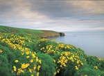
Hike to Arch Point Viewpoint, Santa Barbara Island, California
Great views and wildflowers in season. -
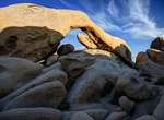
Hike Arch Rock Nature Trail (Joshua Tree), California
Day hikers cannot park at White Tank campground to get to Arch Rock or Heart Rock. Parking is across the street at 2 Tanks and start hike from there. If you are staying at the campground: It's a short loop trail to a natural arch inside the White Tank Campground. Find the 0.3-mile tailhead just off Pinto Basin Road. The trail begins alongside campsite nine, and there... -
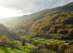
Hike from Arcos de Valdevez to Sistelo, Peneda-Gerês National Park, Portugal
The hike from Arcos de Valdevez to Sistelo is a 20km trail in a Park. It’s easy and most of the way is on wooden walkways. -
Hike Arctic Circle Trail, Greenland
The Arctic Circle Trail is a 160km (99 miles) trekking tour in West Greenland that usually takes 9-11 days to complete. The route fits into one of the largest ice-free areas of West Greenland. The route starts at the international airport at Kangerlussuaq and ends at the Sisimiut airport. Only around 300 people walk the trail every year, but they come from all over E... -
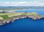
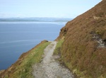
Hike Ardmore Cliff Walk, Ardmore, Ireland
Fabulous views of the cliffs, shipwreck and ruins. -
Hike Arenal Volcano, Costa Rica
Arenal Volcano is an active andesitic stratovolcano in north-western Costa Rica around 90 km (56 mi) northwest of San José, in the province of Alajuela, canton of San Carlos, and district of La Fortuna. The Arenal volcano measures at least 1,633 metres (5,358 ft) high. It is conically shaped with a crater 140 metres (460 ft) in diameter. Geologically, Arenal is... -
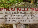
Hike to Arethusa Falls, New Hampshire
Arethusa Falls is a waterfall in the White Mountains of New Hampshire in the United States. The waterfall occurs when the headwaters of Bemis Brook tumble over a granite cliff on the western slope of Crawford Notch. They are sometimes erroneously referred to as the tallest waterfalls in New Hampshire, but they are in fact the second tallest, after the Mahoosuc Range's... -
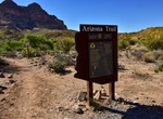
Hike Arizona National Scenic Trail, Arizona
The Arizona National Scenic Trail is a National Scenic Trail from Mexico to Utah that traverses the whole north-south length of the U.S. state of Arizona. The trail begins at the Coronado National Memorial near the US-Mexico border and moves north through parts of the Huachuca, Santa Rita, and Rincon Mountains. The trail continues through the Santa Catalina north of T... -
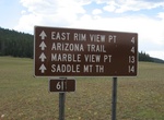
Hike or Mountain Bike Arizona Trail (North Rim), Grand Canyon National Park, Arizona
Arizona Trail on the North Rim of Grand Canyon National Park is 10 miles (16 km) one-way within the park. This section of this trail enters the park near the North Entrance and roughly parallels AZ 67 until it connects with the North Kaibab Trail along Point Sublime Trail. The Arizona Trail is marked with brown fiberglass posts with a Kaibab Plateau Trail decal near t... -
Hike Armijo Canyon, New Mexico
This is a pleasant, 4½ mile hike winds among piñon and juniper trees and will take you to a well preserved pueblo ruin and homestead. Keep in mind this trail can be very sandy. This is a designated Wilderness area and is not accessible by bicycle. The Dittert Site, a pueblo ruin, is at the mouth of Armijo Canyon. Driving Directions: Drive south on NM H... -
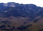
Summit Armstrong Mountain, New York
Armstrong Mountain is a mountain located in Essex County, New York, named after Thomas Armstrong, a local pioneer. The mountain is part of the Great Range of the Adirondack Mountains. Armstrong Mtn. is flanked to the southwest by Gothics, and to the northeast by Upper Wolfjaw Mountain. Armstrong Mountain stands within the watershed of the East Branch of the Ausable R... -
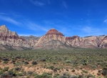
Hike Arnight Trail, Red Rock Canyon, Nevada
Arnight Trail starts from the parking lot, the trail runs toward the escarpment, is intersected by Knoll Trail, then joins Pink Creek Trail just above the loop junction. Difficulty: moderate. Distance: 2.4 miles (3.9 km) round trip. -
Hike Around the Mountain Circuit (AMC), Egmont National Park, New Zealand
The Around the Mountain Circuit (AMC) is a backcountry track for experienced trampers through river, forest and spectacular alpine scenery. North Egmont to Holly Hut (3–4 hr, ~8 km) Holly Hut to Waiaua Gorge Hut (7–9 hr, ~13 km) Waiaua Gorge Hut to Lake Dive Hut (7–8 hr, ~10 km) Lake Dive Hut to North Egmont (4–6 hr, 9 km) Huts along t... -
Hike Arran Coastal Way, Isle of Arran, Scotland
The Arran Coastal Way is a 107 kilometre long-distance trail that goes around the coastline of Arran in Scotland. As the route is circular, following the coastline of the island, it can be started and finished at any location, however in recognition of the fact that most visitors to the island arrive and depart via the Caledonian MacBrayne ferry a start/finish monumen... -
Hike Arrow Canyon, Nevada
Arrow Canyon Wilderness is a 27,530-acre (11,140 ha) wilderness area located in Clark County in the U.S. state of Nevada. It received wilderness designation with the passage of the Clark County Conservation of Public Land and Natural Resources Act of 2002 and protects the northern portion of the Arrow Canyon Range. The Arrow Canyon Wilderness is managed by the Bureau ...


Price: $469.00