Give us feedback!


 See all

Our philosophy is simple. We want to encourage you to dream. BIG! Then we help you plan your trip, get the most out of it while you're traveling and help you share your experience with friends.
Join Now It's FREE
Dream Packages
Duration: 4 days
Price: $1457.59
Price: $1457.59
Duration: 4 hours
Price: $149.99
Price: $149.99
Duration: 4 days
Price: $1026.70
Price: $1026.70
Duration: 2 days
Price: $779.00
Price: $779.00
Related Categories
- Australian National Parks & Reserves
- Canadian National Parks
- Canyoneering
- Day Hikes
- Guided Hikes
- In the Mountains
- Mountaineering
- Mountains
- New Zealand Great Walks
- New Zealand National Parks
- Parks & Reserves
- Rock Climbing
- South African National Parks
- UK National Parks
- UNESCO Parks & Preserves
- US Historical Parks (NHP)
Dreams Still To Do
Checked-Off Dreams
Dreams Still To Do
Checked-Off Dreams
Advertisement
Explore Hikes & Treks
-
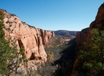
Hike Aspen Trail, Navajo National Monument, Arizona
Aspen Trail starts at the visitor center and then branches off Sandal Trail to descend 300 feet to view ancient aspen forest (0.8-mile round trip). -
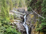
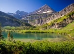
Hike to Aster Falls & Aster Park Overlook, Glacier National Park, Montana
Aster Falls is along Aster Creek in Glacier National Park, Montana. Aster Falls is an easy 2.6 miles out and back. Aster Park Overlook is 3.7 miles out and back. -
Hike Atene Skyline Track, Whanganui National Park, New Zealand
The Atene Skyline Track has spectacular views and a campsite for trampers wanting to stay the night. Beginning at the up-river end, the track climbs steeply from the River Road to a height of 260 m through fine lowland forest. Following an old, gently graded roadline for approximately 3 km the track follows the ridgeline to a clearing which marks the track's halfway ... -
Hike Atene Viewpoint Walk, Whanganui National Park, New Zealand
Just 40 minutes drive from Whanganui this is a great walk for families to a viewpoint over Whanganui National Park - there is a picnic table 20 minutes from the start with spectacular views of the Whanganui River. Dogs with a DOC permit only. Contact the relevant DOC office to obtain a permit. -
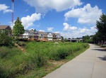
Hike or Ride Atlanta BeltLine, Atlanta, Georgia
The BeltLine (also Beltline or Belt Line) is a former railway corridor around the core of Atlanta, Georgia, under development in stages as a multi-use trail. Some portions are already complete, while others are still in a rough state but hikeable. Using existing rail track easements, the BeltLine is designed to improve transportation, add green space, and promote rede... -
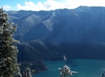
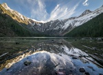
Hike to Atsina Lake, Glacier National Park, Montana
Atsina Lake is in Glacier National Park in the U. S. state of Montana, just to the west of Pyramid Peak. Take the Pacific Northwest Trail/Belly River Trail from Chief Mountain Customs on the United States–Canada border in central Montana. Atsina Lake has several waterfalls nearby including Paiota Falls, Atsina Falls and the Mokowanis Cascade. -
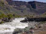
Hike to Auger Falls, Idaho
Auger Falls is along the Snake river in Idaho at elevation of 3,025 feet (922 m). -
Summit Aurora Peak, Olympic National Park, Washington
Aurora Peak is a summit in Olympic National Park in Clallam County, Washington. It is the highest point on Aurora Ridge. The northern flank of the ridge forms a steep escarpment above Lake Crescent, while the southern flank towers above the Sol Duc River. Other summits on the ridge are Sourdough Mountain and Lizard Head Peak. To the east the ridge is known as Happy La... -
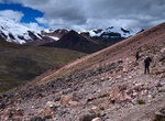
Trek Ausangate Circuit, Peru
Ausangate Trek is traditionally done in 5-6 days circumnavigating the massive Ausangate Peak, a sacred mountain for locals as it is the largest in the area. Unlike the Inca Trail, no permit is needed for the Ausangate trek. The trek is one of the quietest in the region and you’ll likely not see another trekker. With several high passes over 5,000 metres, the Aus... -
Trek Australian Alps Walking Track, Australia
The Australian Alps Walking Track is a long distance walking trail through the alpine areas of Victoria, New South Wales and ACT. It is 655km long, starting at Walhalla, Victoria and running through to Tharwa, ACT near Canberra. The track weaves mainly though Australian national parks, such as Alpine National Park and Kosciuszko National Park, though it is not exclusi... -
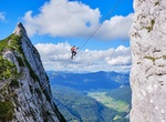
Climb Austria Sky Ladder ("Stairway to Heaven"), Austria
Großer Donnerkogel (Great Donnerkogel) is a 6.4 kilometer out and back trail located near Gosau, Upper Austria. The final leg of this via ferrata route in Austria is not the faint of heart. The 140ft long sky ladder which stretches over a 2296ft abyss is the highlight of a fixed climbing tour of the Donnerkogel. -
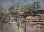
Hike Auxier Ridge Trail, Red River Gorge, Kentucky
Auxier Ridge Trail #204, on Cumberland District, follows a high, narrow ridge 2.1 miles to its end where you can view popular Red River Gorge geologic formations like Double Arch, Haystack Rock, Courthouse Rock, and Raven Rock. Sheer cliffs extend on both sides of the ridge. Auxier Ridge Trail #204 is part of the Auxier Ridge Trail system which includes Courthouse ... -
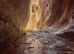
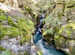
Hike Avakas Gorge, Paphos, Cyprus
Avakas Gorge is a 5.1 mile out and back canyon trail located on the Akamas Peninsula North of Paphos and Coral Bay. Don’t wear sandals since some parts can be really slippery and lots of water, it can get very hot. An alternative is to the dirt road at the end of the gorge and then stoll back on a dirt road back towards the sea. -
Hike Avalanche Creek Trail, Glacier National Park, Montana
The Avalanche Creek area is popular with horseback riders, hikers and backpackers. It's a good backpacking hike with access to the Hell Roaring Trail, East Creek Trail, West Fork Trail and Capitol Lake. The trail begins from the parking lot and ascends through aspen reaching the intersection with the Hell Roaring Trail in 2 1/2 miles. Keep straight, the trail will cro... -
Hike to Avalanche Lake, Glacier National Park, Montana
Avalanche Lake is located in Glacier National Park along Going-to-the-Sun Road. Avalanche Lake is southwest of Bearhat Mountain and receives meltwater from Sperry Glacier. Avalanche Lake is a 2 miles (3.2 km) hike from the trailhead along the Trail of the Cedars.
Price: $263.77