Give us feedback!


 See all

Our philosophy is simple. We want to encourage you to dream. BIG! Then we help you plan your trip, get the most out of it while you're traveling and help you share your experience with friends.
Join Now It's FREE
Dream Packages
Duration: 4 days
Price: $1457.59
Price: $1457.59
Duration: 12 hours 30 minutes
Price: $289.36
Price: $289.36
Duration: 13 hours 30 minutes
Price: $572.77
Price: $572.77
Duration: 6 hours 30 minutes
Price: $167.71
Price: $167.71
Related Categories
- Australian National Parks & Reserves
- Canadian National Parks
- Canyoneering
- Day Hikes
- Guided Hikes
- In the Mountains
- Mountaineering
- Mountains
- New Zealand Great Walks
- New Zealand National Parks
- Parks & Reserves
- Rock Climbing
- South African National Parks
- UK National Parks
- UNESCO Parks & Preserves
- US Historical Parks (NHP)
Dreams Still To Do
Checked-Off Dreams
Dreams Still To Do
Checked-Off Dreams
Advertisement
Explore Hikes & Treks
-
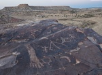
Hike Seismosaurus Trail, Ojito Wilderness, New Mexico
The Seismosaurus Trail is a 2.2 mile out and back trail in the Ojito Wilderness. From Bernalillo, travel on U.S. 550 about 21 miles (about 2 miles before San Ysidro) turning left onto Cabezon Road (County Road 906). Follow the left fork approximately 9 and 1/4 miles to an Ojito Wilderness sign. Continue about 3/4 mile to a undeveloped parking area on the left. A trai... -
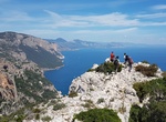
Hike Selvaggio Blu, Sardinia, Italy
The Selvaggio Blu is located about halfway up Sardinia’s east coast and is one of Italy’s hardest treks. It goes from Santa Maria Navarrese to Cala Gonone. -
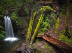
Hike to Sempervirens Falls, Big Basin Redwoods State Park, California
Sempervirens Falls is a little waterfall that is a short out-and-back hike from the visitor center. The trail also has some outstanding redwoods, though mostly at the beginning. -
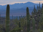
Hike or Ride Sendero Esperanza Trail, Saguaro National Park, Arizona
This trailhead is approximately 6 miles from the Red Hills Visitor Center, 1.5 miles east of the intersection of Hohokam Road and Golden Gate Road. The first mile of trail follows the sandy path of an old mine road. The next .7 mile climbs a series of switchbacks to the top of the ridge where it crosses the Hugh Norris Trail. The trail then descends 1.4 miles on the w... -
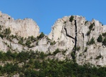
Climb Seneca Rocks, West Virginia
Seneca Rocks is a large crag and local landmark in Pendleton County in the Eastern Panhandle of West Virginia, USA. The south peak is one of a small number of peaks inaccessible except by technical rock climbing techniques on the East Coast of the United States. One of the best-known scenic attractions in West Virginia, the sheer rock faces are a popular challenge for... -
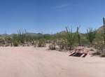
Hike Senita Basin Loop Trail, Organ Pipe Cactus National Monument, Arizona
Senita Basin Loop Trail starts at the end of the Senita Basin Spur Road. Senita Basin is named after the rare Senita cactus, also known as old man cactus. During the winter season, free hiker shuttles are offered to the Senita Basin and Red Tanks Tinaja Trailhead. From these trails, one can easily walk back to the campground. Reserve a spot on the shuttle by calling ... -
Hike Sentier Nepisiguit Mi'gmaq Trail, New Brunswick, Canada
The Sentier Nepisiguit Mi'gmaq Trail is a 147 kilometre wilderness hiking and backpacking trail in New Brunswick, Canada that follows the Nepisiguit River from the Daly Point’s Nature Reserve in Bathurst to Mount Carleton Provincial Park. Officially opened for hiking in 2018, the trail is a recommissioned ancient Mi'gmaq portage route and is one of the eleven si... -
Hike Sentiero dei Fortini Borbonici, Capri, Italy
The Sentiero dei Fortini is a wlking path along the coastline of Anacapri from the Grotta Azzurra to Punta Carena. Along the path are three blockhouses built by the British in 1806 and amplified by the French - Orrico, Mesola and Pino blockhouses. It will take around 3 hours to complete. -
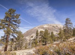
Hike Sentinel Dome, Yosemite National Park
Sentinel Dome is a granite dome in Yosemite National Park, United States. It lies on the south wall of Yosemite Valley, 0.8 miles (1.3 km) southwest of Glacier Point and 1.4 miles (2.3 km) northeast of Profile Cliff. Sentinel Dome is known for a Jeffrey Pine that grew from its peak (see photograph). The pine was photographed as early as 1867 by Carleton Watkins, and w... -
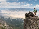
Summit Sepulcher Mountain, Yellowstone National Park, Wyoming
Sepulcher Mountain el. 9,642 feet (2,939 m) is a moderate mountain peak in northwest Yellowstone National Park halfway between the summit of Electric Peak and Mammoth Hot Springs. The peak was named Sepulcher by Captain John W. Barlow, U.S. Army in 1871 because of it resemblance to a crypt when viewed from Gardiner, Montana. The summit of Sepulcher Mountain can b... -
Hike Sequoia and Skyline to the Sea Loop Trail, Big Basin Redwoods State Park, California
If you have half a day, hike a 4-mile loop on the Sequoia and Skyline to the Sea trails. The route leads to a platform overlooking exquisite Sempervirens Falls, then up the broad slope of Slippery Rock to a junction with the Skyline to the Sea Trail. This stretch of Skyline to the Sea passes the site of a pioneer family cabin in the skyscraping redwood forest along Op... -
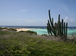
Hike Seroe Colorado Trail, Aruba
Seroe Colorado Trail takes you along most southern tip of Aruba with hidden natural bridge and the volcanic rock formations. -
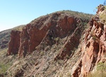
Hike Serpentine Gorge, Northern Territory, Australia
Serpentine Gorge is one of the gorges in the West MacDonnell Ranges in Australia's Northern Territory. It is located approximately 100 kilometres west of Alice Springs along the Larapinta Trail. It comprises two gorges created by a south flowing creek which has cut through two ridges of Heavitree Quarzite. The gorge is home to some rare Central Australian plants such ... -
Hike Serpents Trail, Colorado National Monument
The Serpents Trail in Colorado National Monument, also known as the Trail of the Serpents and the Serpentine Trail, was built by the visionary John Otto, who began the campaign to establish the national monument. The trail was, in fact, a road from Grand Junction, Colorado through No Thoroughfare Canyon to the rimrock near Cold Shivers Point, with an elevation gain of... -
Explore Serra da Freita, Arouca Geopark, Portugal
Majestic peak, located at more than 1000 m altitude, featuring one of Europe's largest waterfalls, walking paths & rural abandoned villages. It is arranged in the northwest-southeast orientation and extends through the parish of Albergaria da Serra, in the extreme southeast of the municipality of Arouca, the parishes of Manhouce and Valadares, the western tip of t...
Price: $371.99