Give us feedback!


 See all

Our philosophy is simple. We want to encourage you to dream. BIG! Then we help you plan your trip, get the most out of it while you're traveling and help you share your experience with friends.
Join Now It's FREE
Dream Packages
Duration: 13 hours 30 minutes
Price: $572.77
Price: $572.77
Duration: 12 hours
Price: $224.21
Price: $224.21
Duration: 6 days
Price: $606.00
Price: $606.00
Duration: 4 days
Price: $1026.70
Price: $1026.70
Related Categories
- Australian National Parks & Reserves
- Canadian National Parks
- Canyoneering
- Day Hikes
- Guided Hikes
- In the Mountains
- Mountaineering
- Mountains
- New Zealand Great Walks
- New Zealand National Parks
- Parks & Reserves
- Rock Climbing
- South African National Parks
- UK National Parks
- UNESCO Parks & Preserves
- US Historical Parks (NHP)
Dreams Still To Do
Checked-Off Dreams
Dreams Still To Do
Checked-Off Dreams
Advertisement
Explore Hikes & Treks
-
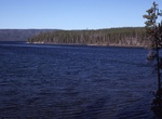
Hike Shoshone Lake Trail, Yellowstone National Park, Wyoming
Shoshone Lake is a backcountry lake with the area of 8,050 acres (32.6 km2) elevated at 7,795 feet (2,376 m) in the southwest section of Yellowstone National Park, Wyoming, US. It lies at the headwaters of the Lewis River a tributary of the Snake River. The U.S. Fish and Wildlife Service believes that Shoshone Lake is the largest backcountry lake in the lower 48 state... -
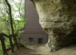
Hike to Shot Tower & Smelter House, Tower Hill State Park, Wisconsin
About two miles of trails meander through Tower Hill State Park. The segment from campsite 13 to the shot tower (0.3 miles) includes a gradual climb and two stairways. The segment from the shelter building to the shot tower (0.2 miles) is a steep uphill climb. The segment from the shot tower to the tunnel at the river bottom (0.2 miles) has long, steep stairways.... -
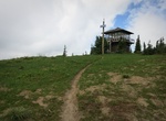
Hike to Shriner Peak Fire Lookout, Mount Rainier National Park
The Shriner Peak Fire Lookout is a fire lookout tower in Mount Rainier National Park. Built in 1932 to a standard design by the National Park Service Branch of Plans and Designs, the wood-frame lookout features a ground-floor storage room and an upper-level lookout and living space with windows on all four sides. A balcony extended around the perimeter of the upper le... -
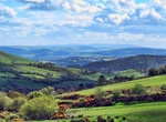
Hike Shropshire Hills, England
The Shropshire Hills is an upland area and one of the natural regions of England. They lie wholly within the county of Shropshire and encompass several distinctive and well-known landmarks, such as the Long Mynd, Wenlock Edge, The Wrekin and the Clees. The Shropshire Hills lie south of the county capital of Shrewsbury between the Welsh border and Much Wenlock, extendi... -
Hike Siamese Twins Trail, Garden of the Gods, Colorado
Siamese Twins Trail is located in the southwest corner of Garden of the Gods near Balanced Rock and the Garden of the Gods Trading Post. The short loop that offers incredible views of Pikes Peak and an up-close look at the Siamese Twins formation. -
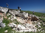
Hike to Sibyl's Cave (Grotta della Sibilla), Montemonaco, Marche, Italy
Sibyl's Cave (Grotta della Sibilla) is a cave, located at 2,150 m above sea level, carved into the rock, near the summit of Sibillini Mountains in the municipality of Montemonaco, reachable only on foot. There, above the peaks of the wild Apennines, Between the steep cliffs a cave appears; The sirens keep watch over that lighthouse, The songs tremble and make one deli... -
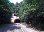
Hike or Ride through Sideling Hill Tunnel, Blueridge Mountain, Pennsylvania
Sideling Hill Tunnel is one of three original Pennsylvania Turnpike tunnels abandoned (this one in 1968) after two massive realignment projects. The others are nearby Rays Hill Tunnel, and farther west, the Laurel Hill Tunnel. It was less expensive to realign the Turnpike than to bore a second tube for four lane traffic. Sideling Hill Tunnel is 6,782 feet (2,067 m) lo... -
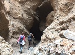
Hike Sidewinder Slot Canyon, Death Valley National Park, California
The hills at the western base of Smith Mountain seem uninteresting from a distance, yet tucked deep within them are some of the narrowest slot canyons in Death Valley. From the southern end of the old gravel pit, walk up the large alluvial fan to the south that leads to a shallow canyon with poorly cemented gravel walls. About a mile in, a major drainage joins from th... -
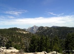
Explore Sierra de San Pedro Mártir National Park, Baja California, Mexico
Sierra de San Pedro Mártir National Park is a national park in the Mexican state of Baja California. The Park is part of the municipality of Ensenada, Baja California. The area was first explored by Europeans in 1701 by Eusebio Francisco Kino by Dominican orders. The park is known for its pine trees and granite rock formations. Sierra de San Pedro Mártir... -
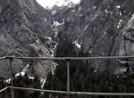
Hike to Sierra Point, Yosemite National Park
WARNING: National Park Service does not recommend that anyone take this trail. Sierra Point is a point located in Yosemite National Park at the eastern end of the valley, below Grizzly Peak, on what is essentially the southern shoulder of Half Dome. The trail used to be quite popular, but was closed due to a rock slide in the 1970s. While a portion of the trail is sti... -
Summit Signal Hill, Cape Town
Signal Hill (Afrikaans:Seinheuwel), or Lion's Rump, is a landmark flat-topped hill located in Cape Town, next to Lion's Head and Table Mountain. The hill was also known as "The Lion's Flank", a term now obsolete. Together with Lion's Head, Signal Hill looks like a lion sphinx. Signal flags were used to communicate weather warnings as well as anchoring instructions to ... -
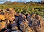
Hike Signal Hill Petroglyphs Trail, Saguaro National Park, Arizona
Signal Hill Trail is located off Signal Hill Picnic Area and include Hohokam Petroglyphs. This easy climb takes you to dozens of petroglyphs scattered around a rocky hilltop. The trail zig -zags up a small hill just north of Signal Hill Picnic Area, which is located off Golden Gate Road, 5 miles from the Red Hills Visitor Center. The trail is rough and uneven in place... -
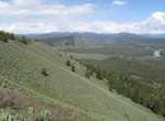
Hike Signal Mountain Trail, Grand Teton National Park, Wyoming
The Signal Mountain Trail is a 6.8-mile (10.9 km) long roundtrip hiking trail in Grand Teton National Park in the U.S. state of Wyoming. The trail begins near Signal Mountain Lodge on Jackson Lake and provides hiking access to the summit of Signal Mountain. The trail passes through Lodgepole Pine forests most of the way and the view from the summit of Signal Mountain ... -
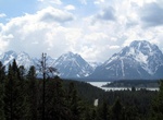
Drive or Bike to Signal Mountain Viewpoint, Grand Teton National Park, Wyoming
Signal Mountain is an isolated summit standing 7,720 feet (2,350 m) above sea level. The mountain is located in Grand Teton National Park in the U.S. state of Wyoming. Signal Mountain has a 5-mile (8.0 km) long road providing vehicular access to an observation area located just below the main summit. The Signal Mountain Trail is a hiking trail that goes from Signal Mo... -
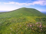
Hike to Signal Peak, Santa Barbara Island, California
Highest point on island with views of Sutil Island. In the spring, wildflowers and green grass blanket Signal Peak (635 feet), the highest of the island's two rounded peaks.


Price: $129.99