Give us feedback!


 See all

Our philosophy is simple. We want to encourage you to dream. BIG! Then we help you plan your trip, get the most out of it while you're traveling and help you share your experience with friends.
Join Now It's FREE
Dream Packages
Duration: 4 hours
Price: $149.99
Price: $149.99
Duration: 2 days
Price: $398.24
Price: $398.24
Duration: 8 hours
Price: $214.32
Price: $214.32
Duration: 4 days
Price: $663.61
Price: $663.61
Related Categories
- Australian National Parks & Reserves
- Canadian National Parks
- Canyoneering
- Day Hikes
- Guided Hikes
- In the Mountains
- Mountaineering
- Mountains
- New Zealand Great Walks
- New Zealand National Parks
- Parks & Reserves
- Rock Climbing
- South African National Parks
- UK National Parks
- UNESCO Parks & Preserves
- US Historical Parks (NHP)
Dreams Still To Do
Checked-Off Dreams
Dreams Still To Do
Checked-Off Dreams
Advertisement
Explore Hikes & Treks
-
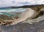
Hike South Coast Track, Tasmania, Australia
The South Coast track in the South Coast Tasmania region is an 82km bushwalking track in the Southwest National Park of Tasmania, Australia. The track starts at Cockle Creek south of Hobart and roughly follows the southern coastline to the isolated locality of Melaleuca, which is accessible only by air, sea and foot. Most walkers fly into Melaleuca and walk out to avo... -
Trek South Coast Track, New Zealand
This track of varying difficulty leads along rugged southern Fiordland coast to Port Craig (easy overnight) and beyond to the more remote Big River (4 days one way). This track can be combined with Teal Bay to South Coast Track and Hump Ridge Track and more (see Moirs Guide South). Rarakau carpark to Port Craig School Hut (7 hours, 20 km): From the Rarakau carpark,... -
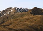
Summit South Dix, New York
South Dix is a mountain located in Essex County, New York. The mountain is part of the Dix Range, named after John A. Dix (1798–1879), New York Secretary of State in 1837, and later Governor. The name is being changed to Carson Peak, after Russell M.L. Carson (1884–1961), author of Peaks and People of the Adirondacks. South Dix is flanked to the northeast ... -
Hike Southend Loop, Cumberland Island National Seashore, Georgia
The Southend loop is a combination of trails, roadways, and boardwalks that will take you through several of the main ecosystems and the largest historic district on the island. You can hike the loop either direction depending on the wind (you want the wind at your back on the beach). If... -
Hike Southern Circuit Stewart Island/Rakiura, New Zealand
Stewart Island/Rakiura's Southern Circuit Track is a remote, challenging tramp and requires good fitness, route-finding skills and backcountry experience. The track traverses the low-lying Freshwater and Rakeahua Valleys, then heads across to Doughboy and Mason Bay. The easiest way to start and finish the Southern Circuit is to arrange a water-taxi pick-up or drop-o... -
Trek Southern Crossing (Tararua Range), New Zealand
The Southern Crossing is the name of a tramping track in New Zealand's Tararua Range. The track is approximately 32 kilometres long and typically takes between 2–3 days to complete. It begins in Otaki Forks in the west, and continues over Mount Hector finishing in Kaitoke north of Upper Hutt. The track starts at Otaki forks, proceeding to Kime Hut via Field Hut.... -
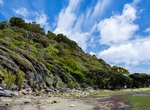
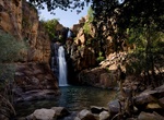
Hike to Southern Rockhole, Nitmiluk National Park, Northern Territory, Australia
Southern Rockhole is an approximate 8 km out and back bush walk of approximately 3 hours from Nitmiluk Visitors Information Centre. -
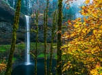
Hike to South Falls, Silver Falls State Park, Oregon
South Falls, is a 177 feet (54 m) waterfall located in the Silver Falls State Park at the east end of the city of Salem, in Marion County, in the U.S. state of Oregon. It is located in a privileged area on the west foothills where Mount Hood National Forest meets with the Middle Santiam Wilderness. Several prominent waterfalls are located in the Park along Trail of Te... -
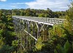
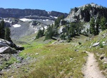
Hike South Fork Cascade Canyon Trail, Grand Teton National Park
The South Fork Cascade Canyon Trail is a 5.6-mile (9.0 km) long hiking trail in Grand Teton National Park in the U.S. state of Wyoming. The trail begins at the Forks of Cascade Canyon and extends to Hurricane Pass. A short connector trail just before Hurricane Pass leads to Schoolroom Glacier. From the Forks of Cascade Canyon and most of the way through South Cascade ... -
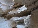
Hike South Fork Palm Wash Slot Canyon, Anza-Borrego Desert State Park, California
South Fork Palm Wash Slot Canyon is located in eastern Anza-Borrego Desert State Park, California Easy to moderate hike with a few obstacles to overcome. 4WD to get to trailhead or walk from near Calcite Road and S22. -
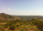
Summit South Fortuna Mountain, San Diego, California
South Fortuna Mountain is located Mission Trails Regional Park. There are two main paths to the peak: Starting from West Fortuna Staging Area (Clairemont Mesa Blvd) it's a 4.75 miles out and back trail. Starting from San Diego River Crossing Staging Area (Mission Gorge Rd) it's a 5.95 miles out and back. The trail is a moderate hike used for hiking, nature trip... -
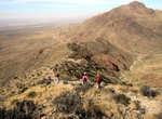
Summit South Franklin Mountain, El Paso, Texas
South Franklin Mountain (6791 ft / 2070 m) is a mountain summit within the Franklin Mountains State Park located in El Paso, Texas. It's accessed from the south via Ron Coleman Trail (Difficult, 4 miles out and back) and from the north via Mammoths Trunk Trail (Difficult, 3 miles out and back). Th area is popular with hikers and rock climbers. Dogs are welcome, but ... -
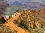
Hike South Kaibab Trail to Phantom Ranch, Grand Canyon National Park, Arizona
The South Kaibab Trail is a 7.1 mi (11.4 km) hiking trail in Grand Canyon National Park, located in the U.S. state of Arizona. Unlike the Bright Angel Trail which also begins at the south rim of Grand Canyon and leads to the Colorado River, the South Kaibab Trail follows a ridge out to Skeleton Point allowing for 360-degree views of the canyon. The South Kaibab T... -
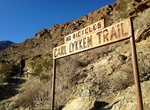
Hike South Lykken Trail, Palm Springs, California
South Lykken Trail is a 4.5 mile trail (1,000 foot elevation gain) on the sourthern end of Palm Springs, California. The 4 hour hike offers scenic views of the mountains and city. The trail is easy iat first then has a pretty good incline for about half a mile. It then winds up the mountain the rest of the trail. The picnic area can also be reach from the Agua Calient... -
Hike South & North Fortuna Loop, Mission Trails Park, San Diego, California
South Fortuna & North Fortuna Mountains are located Mission Trails Regional Park. There are two main paths to the peak: Starting from West Fortuna Staging Area (Clairemont Mesa Blvd) it's a about 8 miles. Starting from San Diego River Crossing Staging Area (Mission Gorge Rd) it's a 7.8 miles. The trail is a moderate hike used for hiking, nature trips, trail r...

Price: $469.00