Give us feedback!


 See all

Our philosophy is simple. We want to encourage you to dream. BIG! Then we help you plan your trip, get the most out of it while you're traveling and help you share your experience with friends.
Join Now It's FREE
Dream Packages
Duration: 30 minutes
Price: $263.77
Price: $263.77
Duration: 4 hours
Price: $129.99
Price: $129.99
Duration: 6 to 10 hours
Price: $86.83
Price: $86.83
Duration: 12 hours
Price: $224.21
Price: $224.21
Related Categories
- Australian National Parks & Reserves
- Canadian National Parks
- Canyoneering
- Day Hikes
- Guided Hikes
- In the Mountains
- Mountaineering
- Mountains
- New Zealand Great Walks
- New Zealand National Parks
- Parks & Reserves
- Rock Climbing
- South African National Parks
- UK National Parks
- UNESCO Parks & Preserves
- US Historical Parks (NHP)
Dreams Still To Do
Checked-Off Dreams
Dreams Still To Do
Checked-Off Dreams
Advertisement
Explore Hikes & Treks
-
Summit Stumpa Dúloigh, Ireland
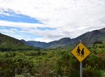
Stumpa Dúloigh (meaning in Irishstump of the black lakeand also known asMaol) is the highest summit of theDunkerron Mountains, part of the Mountains of the Iveragh Peninsula in County Kerry, Ireland. The mountain lies northwest of Knockaunanattin (569 m). West of Stumpa Dúloigh the Dunkerron range splits in two parts: the NE one leads to Broaghnabinnia (... -
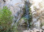
Hike to Sturtevant Falls, Santa Anita Canyon, Califorina
Sturtevant Falls is a easy beginner's trail. The trail is about 3.5 miles round trip. In order to hike this trail you must purchase an adventure pass. It is $5 and you can get it REI or Big 5. -
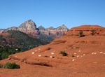
Climb on Submarine Rock, Sedona, Arizona
Submarine Rock in Sedona, Arizona is a very large formation in the shape of a nuclear submarine. The area offers beginning climbers the chance to try out their skills. You can off-road to the rock hike in from Broken Arrow parking lot (about 1.3 miles). -
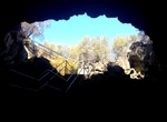
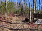
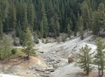
Hike Subway Cave & Lava Tubes Trail, Lassen National Forest, California
Explore the underground world of a lava tube by taking the self-guided trail. Subway Cave & Lava Tubes Trail is approximately 1/3 mile long and the cave is completely dark, so don't your flashlights. The floor is rough and jagged so best to wear sturdy shoes. The cave is usually 46 degrees F. Neither hardhats nor crawling is required! Pets are not allowed. -
Hike Sugarland Mountain Trail, Great Smoky Mountains, Tennessee
The Sugarland Mountain Trail is an American hiking trail, in the Great Smoky Mountains National Park of Sevier County, Tennessee. The trail traverses Sugarland Mountain, a massive ridge running perpendicular to the main crest of the Smokies and effectively dividing the park's north-central section from its northwestern section. Sugarland Mountain is flanked by th... -
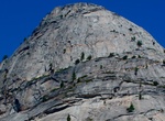
Hike to Sugar Loaf Dome, Yosemite National Park
Sugar Loaf Dome is a granite dome in Yosemite National Park at the northeastern head of Little Yosemite Valley and rises to 7,697 feet (2,346 m) AMSL. Although Sugar Loaf Dome has been repeatedly subject to glaciation, the core of this spur has resisted the icy onslaughts because what remains today is massive throughout except for one master joint, horizontal in chara... -
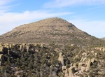
Hike Sugarloaf Mountain Trail, Chiricahua National Monument, Arizona
Rising above the surrounding canyons, the summit of Sugarloaf Mountain at 7,310 ft/2,228 m is one of the highest points in the monument. The dark rock is dacite, evidence of a lava flow. Lightning activity is monitored from the CCC constructed fire lookout during summer. Return the same way. -
Hike Sugarloaf National Recreation Trail, Big Bear, California
Sugarloaf National Recreation Trail is a difficult 10-mile trek to the highest point in Big Bear Valley. The first 2 miles of the trail is a dirt road, at times following Green Creek. Although the view from the summit of Sugarloaf Mountain is mostly obscured by trees you have climbed to an altitude of 9,952 feet. From the south end of Stanfield Cutoff on Big Bear Bou... -
Suggested Itineraries: Family Adventures
Heading out on a desert adventure with kids in tow? Here are some ideas on where to go and what to do to keep the whole family happy. Day 1 - AfternoonTake a stunning drive down Valley of Fire Highway. The main road through Valley of Fire State Park, this highway is paved and easy to drive, giving your family miles of vibrantly colored scenery and photo opportunities... -
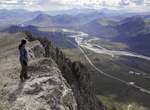
Summit Sukakpak Mountain, Alaska
Sukakpak Mountain (elev. 4,459 ft) is one of the most famous mountain along the Dalton Highway in the Brooks Range of northern Alaska. The trailhead is at milepost 203.1 on Dalton Highway. . -
Hike Sukkertoppen (The Sugar Top), Norway
Sukkertoppen (The Sugar Top) offers magnificent views with both city, coast and fjord. The route as quite steep in places and slippery if it’s been raining. But the views are worth it! -
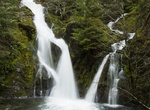
Hike to Sullivan Creek Falls, Oregon
The falls is literally next to FR2207, the road that connects the Little North Fork of the Santiam canyon with Detroit. There is a small parking area with room for 4-5 cars. Sullivan Creek is the largest tributary of Cedar Creek, itself one of the larger feeders of the Little North Santiam River. As the creek drops to it's confluence with Cedar Creek, it cascades d... -
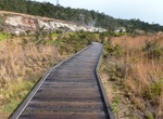
Hike Sulphur Banks Trail (Ha'akulamanu), Hawaii Volcanoes National Park, Hawaii
Across the street from Steaming Bluff and the Steam Vent parking area (Crater Rim Drive) is the trailhead to Sulphur Banks. Redesigned in 2005, the area is now wheelchair accessible along a paved path and boardwalk. At Sulphur Banks (Ha'akulamanu), volcanic gases seep out of the ground along with groundwater steam. These gases are rich in carbon dioxide, sulfur dioxid... -
Hike to Sulphur Springs, Valles Caldera National Preserve, New Mexico
A 0.3-mile (0.5 km) walk along a forested road (VC08) leads hikers to Sulphur Springs, a site bubbling with geothermal features like mudpots and fumaroles. This area was once used for sulfur mining, geothermal energy exploration, and a hot springs health resort/spa. -
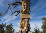
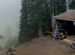
Hike to Summerland Trail Shelter, Mount Rainier National Park
The Summerland Trail Shelter in Mount Rainier National Park is a rustic shelter on the Wonderland Trail, built by the Civilian Conservation Corps in 1934. The shelter features stone walls and a log roof structure, in a saltbox shape, to a design by the National Park Service Branch of Plans and Design, under the supervision of Edwin A. Nickel. Measuring about 15 feet (...


Price: $469.00