Give us feedback!


 See all

Our philosophy is simple. We want to encourage you to dream. BIG! Then we help you plan your trip, get the most out of it while you're traveling and help you share your experience with friends.
Join Now It's FREE
Dream Packages
Duration: 4 hours
Price: $129.99
Price: $129.99
Duration: 4 days
Price: $1457.59
Price: $1457.59
Duration: 10 hours
Price: $121.33
Price: $121.33
Duration: 13 hours 30 minutes
Price: $572.77
Price: $572.77
Related Categories
- Australian National Parks & Reserves
- Canadian National Parks
- Canyoneering
- Day Hikes
- Guided Hikes
- In the Mountains
- Mountaineering
- Mountains
- New Zealand Great Walks
- New Zealand National Parks
- Parks & Reserves
- Rock Climbing
- South African National Parks
- UK National Parks
- UNESCO Parks & Preserves
- US Historical Parks (NHP)
Dreams Still To Do
Checked-Off Dreams
Dreams Still To Do
Checked-Off Dreams
Advertisement
Explore Hikes & Treks
-
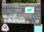
Hike Superior Hiking Trail, Minnesota
The Superior Hiking Trail, also known as The “SHT,” is a 275-mile (442-Km) long footpath in Northeastern Minnesota that follows the ridgeline overlooking Lake Superior for most of its length. The path is 18-inches wide and is set in the middle of a 4 foot clearing. The footpath travels through forests of birch, aspen, pine, fir, and cedar. Hikers enjoy vie... -
Off-road Superstition Mountain OHV Area, California
Superstition Mountain offers great OHV opportunities where visitors can camp, park and ride anywhere. Located north of the Plaster City OHV Open Area, this 13,000 acre open area presents an array of challenging OHV riding opportunities from sand dunes to mud hills. Cross-country OHV use is permitted within the boundaries of this area. Limited use areas and military pr... -
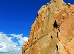
Hike Surprise Canyon, Capitol Reef National Park, Utah
The short Surprise Canyon route crosses a broad, grassy drainage before entering a deep canyon in the Waterpocket Fold. After crossing the dry wash bed of Halls Creek, bear slightly left to crest a small, grassy hill. From here the cairned trail meanders west among colorful outcrops before dropping steeply into a rocky ravine. From here, follow the wash bottom into th... -
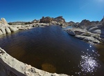
Hike to Surprise Tank, Joshua Tree National Park, California
Surprise Tank can hold a good amount of water after rains. -
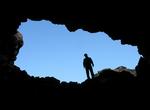
Hike Surtshellir Lava Tube, Iceland
Surtshellir is a lava cave located in western Iceland, around 60 km from the settlement of Borgarnes. Approximately a mile in length, it is the longest such cave in the country. While mentioned in the medieval historical-geographical workLandnámabók, Eggert Ólafsson was the first to give a thorough documentation of the cave in his 1750 travels of ... -
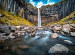
Hike to Susan Creek Falls, Oregon
Susan Creek Falls includes an 0.8 mile accessible trail (rated easy for hiking and difficult for wheelchairs) leads to Susan Creek Falls from Susan Creek Campground. Go a little further for a different view of the falls. The scenic 50-foot waterfall plunges over moss-lined rock cliffs. Enjoy a picnic at the falls. -
Hike or Ride Sutherland Trail, Catalina State Park, Arizona
Sutherland Trail is a 9.1 miles, one-way trail in Catalina State Park. No dogs in Desert Bighorn Sheep Management Area — no bikes in Wilderness Area The first few miles are easy hiking. Beginning at Trailhead parking lot, the trail gradually climbs 700 feet. Plan on 90 minutes of walking time from the Trailhead to park boundary. After 1-mile trail weaves in and... -
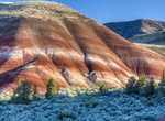
Explore Sutton Mountain Wilderness Study Area, Oregon
The painted hills of the Sutton Mountain Wilderness Study Area in central Oregon. The study area, as described by Bob Wick, BLM photographer, who visited in June of 2016 (edited for brevity, clarity): "It is one of those BLM gems that almost no-one outside the local area has heard about. The lower part of the WSA has exposures of the same clay formations that are fo... -
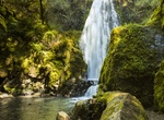
Hike to Svartifoss Waterfall, Iceland
Svartifoss (Black Fall) is a waterfall in Skaftafell National Park in Iceland, and is one of the most popular sights in the park. It is surrounded by dark lava hexagonal columns that were formed inside a lava flow which cooled extremely slowly, giving rise to crystallization. Similar well-known lava formations are seen at the Giant's Causeway in Northern Ireland, and ... -
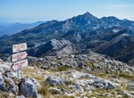
Summit Sveti Ilija, Pelješac peninsula, Croatia
In the western part of Pelješac peninsula is the highest summit of Pelješac, the Zmijino brdo mountain (lit. Snake's Hill) with the peak Sveti Ilija at 961 m or 3,153 ft. -
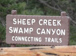
Hike Swamp Canyon Trail, Bryce Canyon National Park, Utah
Swamp Canyon appears relatively small and sheltered from the overlook, bounded on both sides by fins and hoodoos. This size allows the viewer to develop a more intimate connection with the landscape than some of the grander viewpoints may provide. From the Swamp Canyon overlook, hikers can descend to either side of the prominence on a trail that will connect with the... -
Hike Swan Cove Trail, Assateague Island National Seashore, Virginia
The Swan Cove Trail, which branches off from the Wildlife Loop has become an increasingly popular trail out to the beach. Many people have referred to this area as the “bike beach”. The ½ mile trail is accessible by bicycle and foot and leads you from the Wildlife Loop out to a beach area about a mile north of the public parking beach access areas. ... -
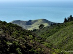
Hike to Sweeney Ridge, Pacifica, California
Sweeney Ridge, is a 1,200-acre (5 km2) hilly hiking area of ridges and ravines between San Bruno and Pacifica, California, about a 25-minute drive south from San Francisco. The ridge’s 1,200-foot-high summit, covered with coastal scrub and grassland, slopes down to San Francisco Bay on the east and to the Pacific Ocean on the west. The ridge is part of the Golde... -
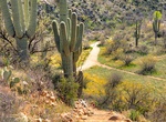
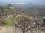
Hike Sweetwater Trail to Wasson Peak, Saguaro National Park, Arizona
The Sweetwater Trail is the only access to Wasson Peak from the eastern side of the Tucson Mountains. The trailhead is located at the western end of El Camino del Cerro Road. The trail climbs 3.4 miles to a ridge where it ends at the King Canyon Trail. To reach Wasson Peak, continue up the King Canyon Trail .9 miles to the Hugh Norris Trail, then .3 miles to Wasson Pe... -
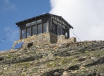
Hike to Swiftcurrent Fire Lookout (Swiftcurrent Mountain), Glacier National Park
The Swiftcurrent Fire Lookout in Glacier National Park is significant as one of a chain of manned fire lookout posts within the park. There are nine remaining fire lookout towers in the park but most are hard to hike to - but most are worth the hike. Swiftcurrent Lookout is one of the easiest to reach. The low two-story timber-construction structure with a gabled roo...

Price: $199.57