Give us feedback!


 See all

Our philosophy is simple. We want to encourage you to dream. BIG! Then we help you plan your trip, get the most out of it while you're traveling and help you share your experience with friends.
Join Now It's FREE
Dream Packages
Duration: 4 hours
Price: $129.99
Price: $129.99
Duration: 2 days
Price: $469.00
Price: $469.00
Duration: 3 hours 15 minutes
Price: $371.99
Price: $371.99
Duration: 4 days
Price: $1026.70
Price: $1026.70
Related Categories
- Australian National Parks & Reserves
- Canadian National Parks
- Canyoneering
- Day Hikes
- Guided Hikes
- In the Mountains
- Mountaineering
- Mountains
- New Zealand Great Walks
- New Zealand National Parks
- Parks & Reserves
- Rock Climbing
- South African National Parks
- UK National Parks
- UNESCO Parks & Preserves
- US Historical Parks (NHP)
Dreams Still To Do
Checked-Off Dreams
Dreams Still To Do
Checked-Off Dreams
Advertisement
Explore Hikes & Treks
-
Hike Tall Trees Grove Trail, Redwood National Park, California
The Tall Trees Trail is a moderately strenuous hike that descends 800-feet down to the alluvial floodplain of Redwood Creek. The grove has plenty of water, good soil, and protection from winter winds and as a result has many redwood trees that exceed 350 feet (106 meters) in height. Hyperion is a coast redwood (Sequoia sempervirens) in California considered the world... -
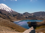
Hike to Tama Lakes, Tongariro National Park, New Zealand
The Tama Lakes (Ngā puna a Tama) are two crater lakes in New Zealand's Tongariro National Park. They fill two (Upper and Lower Tama) of a series of explosion craters on the Tama Saddle between Mount Ruapehu and Mount Ngaruahoe (a main Mount Tongariro vent). Geologically the deep magma source and depth of basement are not usual for vents in the area. The lakes are assu... -
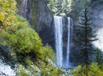
Hike Tamanawas Falls Loop, Oregon
A short 2 to 4 mile hike into the waterfall. There are two locations to park off of HWY 35 so make sure not to leave valuables in the car. The parking location shown on the map is from the Polallie trail head. Park and cross hwy 35 to a steep unmarked trail on the west side. Follow this trail south. It will connect with the Tamanawas fall trail after crossing Cold Spr... -
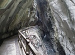
Hike Taminaschlucht (Tamina Canyon), Pfäfers, Switzerland
Taminaschlucht (Tamina Canyon) is a slot canyon along the Tamina River in Pfäfers, Switzerland. -
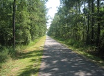
Hike or Ride Tammany Trace, Louisiana
The Tammany Trace is a rail trail in Louisiana occupying a former Illinois Central Railroad corridor. It has been developed into a 31-mile (50 km) asphalt trail for hiking, cycling, and wheelchair use with a parallel equestrian trail. It connects Covington, Abita Springs, Mandeville, Lacombe, and Slidell running along the northshore of Lake Pontchartrain. The trail wa... -
Walk Tampa Riverwalk, Tampa, Florida
Tampa Riverwalk is a 2.6-mile-long (4.2 km) open space and pedestrian trail development along the Hillsborough River in Tampa, Florida. The downtown Tampa portion runs alongside the Tampa Arts District and allows access to Curtis Hixon Park, MacDill Park, Tampa Museum of Art, Glazer Children's Museum, Rivergate Tower, and adjacent atrium containing the Florida Museum ... -
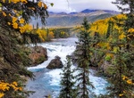
Hike Tanalian Falls and Kontrashibuna Lake, Lake Clark National Park, Alaska
Meander through birch groves and up spruce studded hillsides to a stunning view of Lake Clark. Then round the bend and head down the gentle hill. On a summer day dwarf dogwood lines the trail, the sunlight dapples the forest floor, and the roar of the falls in your ears is deafening. Cold glacial waters fall over a 30 foot cliff of ancient lava. The mist falls coolly ... -
Hike Tanalian Falls Trails, Lake Clark National Park, Alaska
While day hiking opportunities are endless in places that can be reached by plane or boat, there are only two maintained trail system in the park and preserve. The Tanalian Trails originate in Port Alsworth in the heart of the park. The trailhead is located near southern-most airstrip in town. Stop by the park visitor center in Port Alsworth for current trail conditio... -
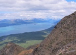
Hike Tanalian Mountain, Lake Clark National Park, Alaska
The trail up Tanalian Mountain is steep and rigorous with stunning panoramic views of Lake Clark and the surrounding mountains.Plan for at least eight hours to complete this trail. The trail begins along the Tanalian Falls Trail and offers views through a birch and spruce forest before starting the ascent up the rocky mountain. Alder and willow line the trail before e... -
Hike Tanawha Trail, Blue Ridge Parkway, North Carolina
The Tanawha Trail, stretching 13.5 miles (21.7 km) from Julian Price Park to Beacon Heights parallels the Blue Ridge Parkway on Grandfather Mountain in North Carolina, in the United States. Tanawha, the Cherokee word for fabulous hawk or eagle is an appropriate name for this trail that offers hikers views of distant mountains. Completed in 1993, the Tanawha Trail, lik... -
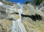
Hike to Tangerine Falls, Santa Barbara, California
Tangerine Falls is Santa Barbara’s biggest at 100-feet (when it is in season - optimal March through November). The trail to Tangerine Falls is a 2.2 mile out and back trail located near Santa Barbara, California. Start at the Cold Spring Trail.head -
Do Tanjong Rimau Intertidal Walk (Siloso Headland), Sentosa, Singapore
Siloso Headland, also known as Tanjong Rimau, is touted to be one of Singapore’s last remainder of coastal cliff and rocky shores. -
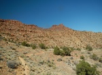
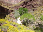
Hike Tanner Trail, Grand Canyon National Park, Arizona
The 9 mile Tanner Trail is a hiking trail located on the South Rim of the Grand Canyon National Park, located in the U.S. state of Arizona. The trailhead is located at Lipan Point, a prominent lookout located to the east of the Grand Canyon Village and it ends at the Colorado River at Tanner Rapids. With its length, difficulty level, remoteness, and rewarding views, t... -
Hike to Tanque Verde Falls, Arizona
Tanque Verde Falls are a series of waterfalls in Tanque Verde Canyon east of Tanque Verde, Arizona and Tucson, Arizona. Tanque Verde Ridge of the Rincon Mountains lies to the south and Agua Caleinte Hill to the north. The falls lie south of Redington Road which connects the Tucson Valley to the southwest with the San Pedro River valley to the east. Visitors now have a... -
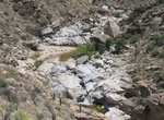
Hike Tapeats Creek to Thunder River, Colorado River, Arizona
Tapeats Creek is a creek located entirely within the Grand Canyon National Park. large creek entering at river right. A popular hike up Tapeats Creek leads to Thunder River. It flows southwest from its source near the North Rim of the canyon to the Colorado River at the base of the canyon. It was named by the Second Powell Expedition in the winter of 1871–1872 f...


Price: $341.00