Give us feedback!


 See all

Our philosophy is simple. We want to encourage you to dream. BIG! Then we help you plan your trip, get the most out of it while you're traveling and help you share your experience with friends.
Join Now It's FREE
Dream Packages
Duration: 30 minutes
Price: $263.77
Price: $263.77
Duration: 12 hours
Price: $263.50
Price: $263.50
Duration: 10 hours
Price: $121.33
Price: $121.33
Duration: 3 hours 15 minutes
Price: $371.99
Price: $371.99
Related Categories
- Australian National Parks & Reserves
- Canadian National Parks
- Canyoneering
- Day Hikes
- Guided Hikes
- In the Mountains
- Mountaineering
- Mountains
- New Zealand Great Walks
- New Zealand National Parks
- Parks & Reserves
- Rock Climbing
- South African National Parks
- UK National Parks
- UNESCO Parks & Preserves
- US Historical Parks (NHP)
Dreams Still To Do
Checked-Off Dreams
Dreams Still To Do
Checked-Off Dreams
Advertisement
Explore Hikes & Treks
-
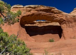
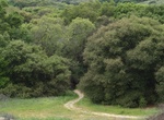
Hike to Tapestry Arch, Arches National Park, Utah
Tapestry Arch is a short hike from the end of the Devils Garden Campground(near trailhead for Broken Arch). -
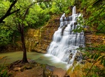
Hike to Tarzan Falls, Guam
The hike to Tarzan Fallsis along a scenic, shaded trail. -
Trek the Tasmanian Trail, Tasmania, Australia
The Tasmanian Trail is a long distance path in Tasmania, Australia. This long-distance multi-use trail stretching from the northern town of Devonport south to Dover. It was inspired by the Bicentennial National Trail opened on the mainland in 1988. It runs from Devonport in the north of the state to Dover in the South East and is 460 km long. It consists of 15 section... -
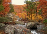
Hike Taum Sauk Mountain, Iron County, Missouri
Taum Sauk Mountain in the Saint Francois Mountains is the highest natural point in the U.S. state of Missouri at 1,772 feet (540 m). The topography of Taum Sauk is that of a somewhat flat ridge rather than a peak. While not as impressive at 1,772 feet (540 m) as other peaks, Taum Sauk and the St. Francois range are true mountains, being the result of a volcanic orogen... -
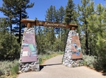
Hike along Taylor Creek (Lake Tahoe), California
Taylor Creek is a 2.2-mile-long (3.5 km) northward-flowing stream originating in the Fallen Leaf Lake and culminating at Baldwin Beach at Lake Tahoe, about 1 mile (1.6 km) west of Camp Richardson in El Dorado County, California. From Memorial Day weekend through October, the Stream Profile Chamber at the Taylor Creek Visitor Center is an opportunity to see the trout a... -
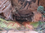
Hike Taylor Creek Trail to Double Arch Alcove, Zion National Park, Utah
The Taylor Creek Trail leads hikers deep into a narrow box canyon toward the Double Arch Alcove, where erosion has carved out natural openings in the Navajo sandstone. As the trail reaches the mouth of the canyon it enters the Zion Wilderness and begins to crisscross Taylor Creek. The trail passes the geologic formation of the Kanarraville Fold and two historic h... -
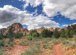
Hike or Mountain Bike Teacup Trail, Sedona, Arizona
The best place to view this Teacup Rock is from the short and scenic Teacup Trail, which crosses the Soldier Pass area before traversing the base of Coffee Pot Rock. -
Hike Te Araroa Trail, New Zealand
Te Araroa (The Long Pathway) is New Zealand's newest long distance tramping route, from Cape Reinga to Bluff. The 3000 km route officially opened on December 3, 2011 after 10 years of work by hundreds of volunteers. Construction coordinated by the Te Araroa Trust is ongoing. The trail has approximately 300 sections ranging from walks of 1–2 hours through to a 9-... -
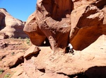
Hike to Teardrop Arch & Rock Door Mesa Anasazi Cliff Dwelling, Monument Valley, Utah
Teardrop Arch is located west of Interstate 163 near Gouldings Lodge just north of the Utah/Arizona border. Take a sandy orad to Horse Shoe Canyon. It's a short 15 minute hike to the arch. -
Hike Tecolote Canyon Trail, San Diego, California
Tecolote Canyon Trail is a 6 mile out and back trail located near San Diego, CA and is good for all skill levels. The route is well marked and has a few steep hills. The trail is dog friendly. -
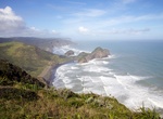
Hike Te Henga Walkway, New Zealand
The Te Henga Walkway takes trampers through the Waitakere Ranges, past the Arataki Visitor Centre, Huia, Whatipu, Karekare, Piha, Anawhata, and either winding north to Muriwai via the Te Henga Walkway, or through Cascade Kauri Park and onto Swanson. From Bethells Rd to Constable Rd is 8 km or 3-4 hr one way. From Bethells Rd to O’Neill’s Bay is 2 km or 45... -
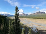
Explore Teklanika River, Denali National Park, Alaska
The northern part of this unit contains rolling hills and dwarf birch shrubland. The midsection of the unit includes Cathedral Mountain on the west side of Teklanika River and Double Mountain on the east. Cathedral Mountain is made up of many small alpine valleys with interconnecting passes. The southern end of the unit is the headwaters of the Teklanika River and the... -
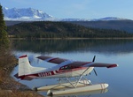
Hike Telaquana Lake to Twin Lakes, Lake Clark National Park, Alaska
There is only 1 way in and out if you want to hike Telaquana Lake to Twin Lakes, by floatplane. This hike is considered an easy hike to complete and full of wildlife. You are bound to see aribou, moose, Dall sheep, and possibly brown bears. Allow six or seven days and some time to check out the handcrafted cabin built by locally fabled naturalist/mountain man Dick Pro... -
Hike to Teleglobe Satellite Station Ruins, Nova Scotia, Canada
The Teleglobe earth-satellite station was built in Charleston in 1963. It was the creation of the Canadian Department of Transport, Telecommunications & Electronics Division, the station was active from 1965 until 1995 and was instrumental in broadcasting worldwide events seen across the globe. It was once one of only 5 Satellite Stations in the world like it and ... -
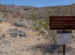
Hike Telephone Canyon Trail, Big Bend National Park, Texas
The primitive Telephone Canyon Trail begins at near Telephone Canyon campsite #2 (TC-2) and travels through the Deadhorse Mountains. TC-1 is quite close to the Old Ore Road. Good views of the Deadhorse mountains and massive limestone cliffs to the east. No other distant views of mountains. Telephone Canyon hikers must park off the road, not in the TC-2 site. Only pe...


Price: $224.21