Give us feedback!


 See all

Our philosophy is simple. We want to encourage you to dream. BIG! Then we help you plan your trip, get the most out of it while you're traveling and help you share your experience with friends.
Join Now It's FREE
Dream Packages
Duration: 12 hours
Price: $160.26
Price: $160.26
Duration: 4 days
Price: $663.61
Price: $663.61
Duration: 4 hours
Price: $129.99
Price: $129.99
Duration: 12 hours
Price: $154.81
Price: $154.81
Related Categories
- Australian National Parks & Reserves
- Canadian National Parks
- Canyoneering
- Day Hikes
- Guided Hikes
- In the Mountains
- Mountaineering
- Mountains
- New Zealand Great Walks
- New Zealand National Parks
- Parks & Reserves
- Rock Climbing
- South African National Parks
- UK National Parks
- UNESCO Parks & Preserves
- US Historical Parks (NHP)
Dreams Still To Do
Checked-Off Dreams
Dreams Still To Do
Checked-Off Dreams
Advertisement
Explore Hikes & Treks
-
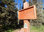
Hike to The Brothers Base Camp, Olympic National Forest, Washington
This trail enters The Brothers Wilderness. Hike through a remote canyon area called the Valley of the Silent Men. The Brothers were named in 1856 by George Davidson of the U.S. Coast Survey after the Fauntleroy brothers - Edward (South peak) and Arthur (north peak) who were brothers of Constance and Ellinor Fauntleroy (the latter was fiancée of George Davidson)... -
Find The Brunette Lady of Joshua Tree, Joshua Tree National Park, California
The Brunette Lady of Joshua Tree is a Chemehuevi Indian sites (another one "The Red Lady") in the Wonderland of Rocks, Joshua Tree National Park. The Brunette Lady is not far from The Red Lady. The Brunette Lady site is that reportedly on the Spring equinox, the sun will shine directly through a small notch on a distant ridge at sunrise. It can only be seen if you are... -
Hike The Bump And Grind, Palm Desert, California
The Bump And Grind is a 3.4 miles out and back trail located in Palm Desert, California. It offers a nice, rigorous hike on the way up and easy to walk down. -
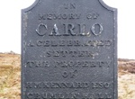
Hike to The Carlo Memorial (The Dog Stone), Varteg, Wales
This memmorial was erected to the memory of Carlo, a setter owned by Henry Martyn Kennard of Crumlin Hall. Carlo was accidently killed during a shooting party organised by the Blaenavon Company on the 'Glorious Twelfth' of 1864. Kennedy ordered that the dog be buried where he was shot and then arranged for the memorial to be cast, presumably in the Blaenavon Ironworks... -
Explore The Chains, Lake Powell, Utah
Explore this area with a self guided adventure through slickrock sand formations. Great views of canyon walls and the Glen Canyon Dam. Lakeshore access is possible depending on the current lake elevations.The lake is very deep at this location and good swimming skills are required.Trailhead: Just east of Glen Canyon Dam, take a gravel road heading north off of Highway... -
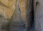
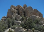
Climb through The Chasm of Doom, Joshua Tree National Park, California
The Chasm of Doom is more of a tight secret passage than a large open chasm that traverses through a large mountain of boulders in the Hidden Valley area. This place is NOT for the faint of heart or the claustrophobic. Not only you’ll need to be comfortable and able to fit in tight spaces, but you will also need to be able to climb, scramble, and boulder in the ... -
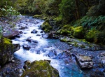
Hike The Chasm Walk, New Zealand
The Chasm Walk is an easy 20 minute hike along the Cleddau River with powerful waterfalls and water-sculpted shapes in the rocks. -
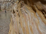
Hike The Chute at Muddy Creek, Utah
Muddy Creek is a stream which drains portions of Emery and Wayne Counties in central Utah, in the western United States. It begins on the eastern slopes of the Wasatch Plateau at elevations above 10,500 feet (3200 m). It turns southward near the town of Emery, then southeastward where it crosses under Interstate 70. It then directly enters the western flank of the San... -
Hike The Cinder Track, North York Moors National Park, England
The Cinder Track, between Scarborough and Whitby, is a popular off road route through the North York Moors National Park, just inland from the stunning North Yorkshire coast. From 1885 until it’s closure in 1965 the old railway line from Scarborough to Whitby took goods and passengers up and down the North Yorkshire coast. Now that it’s an off road route ... -
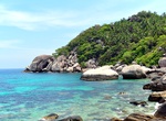
Hike The Coast from Mae Haad to Chalok, Ko Tao, Thailand
This hike is easy and goes from south-west part of the island to the south. You will visit 7 beaches located close to each other. Bring enough water with you and a hat. -
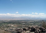
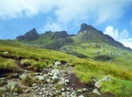
Summit The Cobbler, Scotland
The Cobbler is a mountain of 884 metres (2,900 ft) height located near the head of Loch Long in Scotland. Although only a Corbett, it is "one of the most impressive summits in the Southern Highlands", and is also the most important site for rock climbing in the Southern Highlands. Many maps include the name Ben Arthur (an anglicisation of the Gaelic), but the nameThe ... -
Hike The Colorado Trail, Colorado
The Colorado Trail is a 486-mile (782 km) long trail running from the mouth of Waterton Canyon southwest of Denver to Durango in Colorado, United States. A person with a light pack and who is in shape can do in four weeks without too much trouble. Its highest point is 13,271-foot (4,045 m) above sea level, and most of the trail is above 10,000-foot (3,000 m). Despite ... -
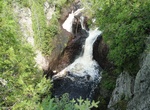
Hike to The Devil's Kettle Falls, Minnesota
The Judge C. R. Magney State Park is best known for "The Devil's Kettle", an unusual waterfall located on the Brule River 1.5 miles (2.4 km) from its mouth. The river splits in two to flow around a mass of rhyolite rock. The eastern flow goes over a two-step, 50-foot (15 m) waterfall and continues downstream. The western flow surges into a pothole, falling at least 10... -
Hike The Dingle Way, Ireland
The Dingle Way (Irish:Slí Chorca Dhuibhne) is a long-distance trail around the Dingle Peninsula in County Kerry, Ireland. It is a 162-kilometre (101-mile) long circular route that begins and ends in Tralee and is typically completed in eight days. It is designated as a National Waymarked Trail by the National Trails Office of the Irish Sports Council and is man... -
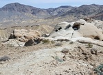
Hike The Domelands & Wind Caves Trail, Coyote Mountains Wilderness, California
The Domelands Trail is a 8 mile loop trail located near Ocotillo, California. Along the trial find fossils, wildlife and some wind tunnels. It's located outside of Anza-Borrego State Park in the Coyote Mountains Wilderness. Access the trailhead by taking a 4WD road from Imperial Highway. There is nothing marking this trail - no signs, no visible path. Mak sure to br...


Price: $779.00