Give us feedback!


 See all

Our philosophy is simple. We want to encourage you to dream. BIG! Then we help you plan your trip, get the most out of it while you're traveling and help you share your experience with friends.
Join Now It's FREE
Dream Packages
Duration: 6 to 10 hours
Price: $86.83
Price: $86.83
Duration: 8 hours
Price: $214.32
Price: $214.32
Duration: 6 hours 30 minutes
Price: $167.71
Price: $167.71
Duration: 2 days
Price: $469.00
Price: $469.00
Related Categories
- Australian National Parks & Reserves
- Canadian National Parks
- Canyoneering
- Day Hikes
- Guided Hikes
- In the Mountains
- Mountaineering
- Mountains
- New Zealand Great Walks
- New Zealand National Parks
- Parks & Reserves
- Rock Climbing
- South African National Parks
- UK National Parks
- UNESCO Parks & Preserves
- US Historical Parks (NHP)
Dreams Still To Do
Checked-Off Dreams
Dreams Still To Do
Checked-Off Dreams
Advertisement
Explore Hikes & Treks
-
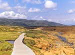
Hike Tablelands Trail, Gros Morne National Park, Newfoundland and Labrador
Half a billion years in the making – formed deep in the middle layer of the Earth, in the mantle. It was thrust up as ancient continents collided, building the Appalachian Mountain chain and assembling a supercontinent called Pangea! More that 400 million years of those towering mountains eroding were needed to reveal what we see today: a surreal barren, orange ... -
Hike Table Rock Loop Trail, Maine
The Table Rock Loop trail in Maine's Grafton Notch State Park is a 2.4 miles round trip hike to the great views from Table Rock, 900 feet above the trailhead. From the rock there are great views of Old Speck Mountain, the Eyebrow, and Grafton Notch. -
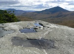
Summit Table Top Mountain, New York
Table Top Mountain is a mountain located in Essex County, New York. Table Top Mtn. is flanked to the north by Phelps Mountain, and to the south by Mount Marcy. Table Top has three summits; the southernmost is the highest, followed by the middle peak (1,312 m) and the north peak (1,285 m). Table Top Mountain stands within the watershed of the Ausable River, which drain... -
Hike Tabletop Track, Litchfield National Park, Northern Territory, Australia
The Tabletop Track, within Litchfield National Park, is a 39 kilometre bushwalk along trickling creeklines, cascading waterfalls, crystal clear pools and undisturbed pockets of tropical monsoon rainforest. The Tabletop Track is an excellent, long bushwalk that lets you experience the remote wilderness of the Top End. The walk takes you through Litchfield National Pa... -
Hike Tabor Canyon (Steinbeck Canyon), Loreto, Baja California Sur, Mexico
Tabor Canyon (also called Steinbeck Canyon) is probably the most well-known hike in the Loreto area and hikers will be rewarded with pools, waterfalls, and even cave paintings. How to Hike There: While there are relatively few Baja hiking books available, Loreto is lucky to be the exception buy ativan the uk with the detailed Hiking Loreto book. While there are plent... -
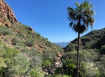
Canyoneer Tachevah Canyon Dry Falls, Palm Springs, California
Tachevah Canyon is a lesser known canyon in the San Jacinto Canyons and has eluded many canyoneers due the strenuous and long approach required to descend the canyon. The highlight of this canyon is the last section which ends with a spectacular 500' multi-pitch drop called Dry Falls. A group of canyoneers in early 2016 completed the full route of Tachevah and reporte... -
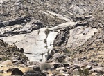
Hike to Tachevah Canyon Dry Falls (North Lykken Trail), Palm Springs, California
Tachevah Falls, which, despite being dry most of the year, is very visually striking place to hike to in Palm Springs. There are three trailheads. Start at the North Lykken Trail at southern end of N Patencio Road with a climb up the mountain. This is 1.4 miles one-way to the base of the fall. Start at Los Robles Drive which cuts through the northern end of the res... -
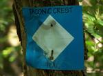
Hike Taconic Crest Trail, Massachusetts
The Taconic Crest Trail is a 35 mi (56 km) hiking trail in the Taconic Mountains. The trail extends from U.S. Route 20 in Hancock, Massachusetts, less than 1 mi (1.6 km) east of the New York border, north along the ridgecrest of the Taconic Range, first within Massachusetts, then weaving along the border of New York and Massachusetts and New York and Vermont, and endi... -
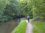
Hike or Ride Taff Trail, Wales
The Taff Trail is a popular walking and cycle path that runs for 55 miles (89 km) between Cardiff Bay and Brecon in Wales. It is named so because it follows the course of the River Taff. Along much of its length, it follows the National Cycle Network Route 8 (Lôn Las Cymru) that continues to Holyhead, and is substantially off-road. The trail makes much use of an... -
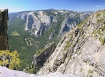
Hike Taft Point Trail, Yosemite National Park
The Taft Point trailhead is located about 5 minutes before the end of Glacier Point road. The trail itself is a 1 mile (1.6 km) (2nd half of the hike is downhill) hike from the trailhead. Taft Point is fairly remote and unpopulated. The trail begins somewhat unguarded from the sun but transitions into a shaded flat walkway through a green meadow. The final approach of... -
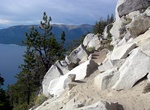
Hike/Bike Tahoe Rim Trail, California
The Tahoe Rim Trail is a 165-mile (266 km) long-distance hiking trail which forms a loop around Lake Tahoe in the Sierra Nevada and Carson ranges of California and Nevada in the United States. The trail ranges in elevation from 6,240 feet (1,900 m) at the outlet of Lake Tahoe to 10,338 feet (3,151 m) at Relay Peak in Nevada. About 50 miles (80 km) of trail above the l... -
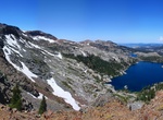
Hike Tahoe–Yosemite Trail (TYT), Sierra Nevada, California
The Tahoe–Yosemite Trail (TYT) is a long-distance trail in the Sierra Nevada mountain range of California. The trail courses 186 miles (299 km) from Meeks Bay at Lake Tahoe to Tuolumne Meadows in Yosemite National Park. The trail is a foot and equestrian path that passes through the Desolation, Mokelumne, Carson-Iceberg, Emigrant, and Yosemite Wilderness Areas a... -
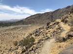
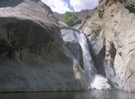
Hike Tahquitz Canyon to Tahquitz Falls, Palm Springs, California
Tahquitz Canyon is one of the most beautiful and culturally sensitive areas of the Agua Caliente Band of Cahuilla Indians Reservation. Tahquitz Canyon is home to a spectacular seasonal 60-foot waterfall, rock art, ancient irrigation systems, native wildlife, and plants. Located at the entrance to the canyon, the Tahquitz Canyon Visitor Center offers educational and cu... -
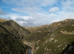
Hike Taieri Gorge, New Zealand
The Taieri Gorge is located on the Taieri River, in the South Island of New Zealand. It is a deep canyon carved by the Taieri River on the middle stage of its journey from Central Otago to the Pacific Ocean, between the high plateau of the Maniototo and the coastal Taieri Plains. The gorge is over 40 kilometres (25 mi) long and stretches from near Pukerangi to southea... -
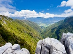
Explore Takaka Hill, New Zealand
Takaka Hill is a range of hills located in the northwest of the South Island of New Zealand. Made of marble which has weathered into many strange forms and with numerous sink holes, it is typical karst country. There is only one road winding over and around the flanks of Takaka Hill, State Highway 60, following the valleys of the Takaka River to the northwest and...
Price: $663.61