Give us feedback!


 See all

Our philosophy is simple. We want to encourage you to dream. BIG! Then we help you plan your trip, get the most out of it while you're traveling and help you share your experience with friends.
Join Now It's FREE
Dream Packages
Duration: 12 hours
Price: $154.81
Price: $154.81
Duration: 3 hours 15 minutes
Price: $371.99
Price: $371.99
Duration: 10 hours
Price: $199.57
Price: $199.57
Duration: 12 hours
Price: $224.21
Price: $224.21
Related Categories
- Australian National Parks & Reserves
- Canadian National Parks
- Canyoneering
- Day Hikes
- Guided Hikes
- In the Mountains
- Mountaineering
- Mountains
- New Zealand Great Walks
- New Zealand National Parks
- Parks & Reserves
- Rock Climbing
- South African National Parks
- UK National Parks
- UNESCO Parks & Preserves
- US Historical Parks (NHP)
Dreams Still To Do
Checked-Off Dreams
Dreams Still To Do
Checked-Off Dreams
Advertisement
Explore Hikes & Treks
-
Hike West Fork Dosewallips River Trail to Enchanted Valley, Olympic National Park, Washington
The West Fork Dosewallips River Trail is a 30.3 mile out and back trail starting at Dosewallips Campground. Dosewallips Road is washed-out 5.5 miles from the trailhead. Hikers can get around the washout using a temporary trail. Obtain your Wilderness camping permit through the Wilderness Information Center (WIC) in Port Angeles, year-round. Call (360)565-3100 for pe... -
Hike West Fork Humptulips Trail, Grays Harbor County, Washington
The entire West Fork Trail #806 is about 17 miles in length. Trail grades are generally 0-10% with a few grades of up to 20%. This trail follows the river within a remote valley defined by the heights of Colonel Bob Wilderness to the west and Stovepipe and Moonlight Dome peaks to the east. The trail fords the river multiple times and winds along the western edge of Mo... -
Hike or Ride West Glacier Trail (Mendenhall Glacier), Alaska
The West Glacier Trail is 3.5 miles long. It begins at end of Skater's Cabin Road and ends at the junction of the Mt. McGinnis Route. The West Glacier trailhead cannot be reached from the Mendenhall Glacier Visitor Center. The trail begins on the north side of the parking lot. Most of this walk is below the glacier trimline amid many willow, cottonwood, and alder tre... -
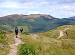
Hike West Highland Way, Scotland
The West Highland Way is a linear long distance footpath in Scotland, with the official status of Long Distance Route. It is 154.5 km (96.0 mi) long, running from Milngavie north of Glasgow to Fort William in the Scottish Highlands, with an element of hill walking in the route. It is managed by the West Highland Way Management Group (WHWMG) consisting of West Dunbarto... -
Hike West Lake Trail, Everglades National Park, Florida
This self-guided boardwalk trail wanders through a forest of white mangrove (Laguncularia racemosa), black mangrove (Avicennia nitida), red mangrove (Rhizophora mangle), and buttonwood (Conocarpus erectus) trees to the edge of West Lake. Seven miles (11km) north of the Flamingo Visitor Center on the main park road. -
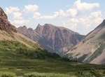
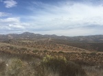
Hike West Maroon Pass from Crested Butte to Aspen, Colorado
This 11-mile hike is spectacular with views of Maroon Bells. This popular pedestrian 'highway' from Crested Butte to Aspen offers great views from the summit in every direction. West Maroon Trail #1970 starts at Maroon Lake and climbs through aspen trees to Crater Lake. Take the left fork at Crater Lake. After the lake the trail follows the stream for a short distanc... -
Explore West Maui Forest Reserve, Maui, Hawaii
Lush mountainous forest nature reserve with waterfalls, hiking trails & volcanic rock formations. The reserve was first designated on August 21, 1908, by Governorʻs Proclamation, and currently consists of approximatley 11,416 acres. West Maui Forest Reserve currently consists of twelve separate sections of Mauna Kahalwai. -
Hike West Mesa Trail, Cuyamaca Rancho State Park, California
West Mesa is a 5.1 mile loop trail located in Cuyamaca Rancho State Park, California. It offers great views of Cuyamaca Peak and Stonewall Peak. Airplane Monument atop was worth the hike to honor the fallen U.S. servicemen -
Hike West Ridge Trail, Prairie Creek Redwoods State Park, California
Marked trailhead is at the Prairie Creek Visitor Center. Trail can also be accessed via Zig Zag Trail #1 and #2, Cathedral Trees Trail, and the Butler Creek Trail. Travel nearly the entire length of the Newton B. Drury Scenic Parkway along this moderately strenuous trail through breathtaking old-growth redwoods. Two backpacking routes are possible by taking the Ossag... -
Hike West Rim Trail, Zion National Park, Utah
The trail starts at the West Rim trailhead near Lava Point and traverses across the high alpine elevation with sweeping views out into the Wildcat Canyon area for the first 6.5 miles as you drop into Potato Hollow. Next the trail climbs out of Potato Hollow before it splits into the Telephone Canyon Trail and the West Rim trail. The West Rim Trail follows along the ri... -
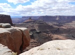
Hike West Rim Trail (Dead Horse Point), Dead Horse Point State Park, Utah
The West Rim is the longest hiking trail at Dead Horse Point State Park. From the visitor center, the route crosses the road and passes briefly through the campground before following the cliffs that form the western boundary of the park. This trail is more primitive, and usually less traveled than the East Rim. Make sure to follow the cairn-marked routes over exposed... -
Hike West River Trail (WRT), Vermont
The WRT is a 36-mile scenic (former railbed) all-season trail through the West River Valley. When connected, sections of the trail will link Brattleboro, Dummerston, Newfane, Townshend, Jamaica and South Londonderry. LowerSectiontrailmap (pdf) UpperSectiontrailmap (pdf) -
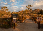
Hike West Side Loop Trail, Joshua Tree National Park
West Side Loop Trail explores the ridge and washes west of Black Rock Campground in Joshua Tree National Park. Leave from the High View Nature Trail connector, west of the nature center between sites 20 and 21. At the junction follow signs for West Side Loop, or start from the High View Nature Trail parking area. -
Hike or Ride West Sycamore 16 Trail, Mission Trails Regional Park, California
Hike, mountain bike or equestian West Sycamore 16 Trail. The trailhead is located just outside the gate to West Sycamore Staging Area in Mission Trails Regional Park. It's heads south for 0.35 miles and then forks into two 0.25 mile brands that both end at Marine Corps Air Station (MCAS) Miramar. -
Go on West Sycamore Nature Walk, Mission Trails Regional Park, California
Join Ranger Andrew Miller on the third Sunday of every month at 8 am at the Goodan Ranch Staging Area (Located at the very end of Sycamore Canyon Road at 16281 Sycamore Canyon Road Poway, CA 92064) for a 90 minute guided nature walk. He will focus on the plant communities commonly found at West Sycamore. Please wear comfortable shoes, a hat and bring bottled water.


Price: $86.83