Give us feedback!


 See all

Our philosophy is simple. We want to encourage you to dream. BIG! Then we help you plan your trip, get the most out of it while you're traveling and help you share your experience with friends.
Join Now It's FREE
Dream Packages
Duration: 2 days
Price: $469.00
Price: $469.00
Duration: 30 minutes
Price: $263.77
Price: $263.77
Duration: 3 hours 15 minutes
Price: $371.99
Price: $371.99
Duration: 4 hours
Price: $149.99
Price: $149.99
Related Categories
- Australian National Parks & Reserves
- Canadian National Parks
- Canyoneering
- Day Hikes
- Guided Hikes
- In the Mountains
- Mountaineering
- Mountains
- New Zealand Great Walks
- New Zealand National Parks
- Parks & Reserves
- Rock Climbing
- South African National Parks
- UK National Parks
- UNESCO Parks & Preserves
- US Historical Parks (NHP)
Dreams Still To Do
Checked-Off Dreams
Dreams Still To Do
Checked-Off Dreams
Advertisement
Explore Hikes & Treks
-
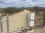
Hike or Ride West Sycamore North Trail, Mission Trails Regional Park, California
Hike, mountain bike or equestian West Sycamore North Trail. The trailhead is located at the northern end of West Sycamore Staging Area in Mission Trails Regional Park. It's heads north for 0.3 miles and then forks into 3 short branches. The northern branch connects with the trail connecting Beeler Canyon Rd and Goodan Ranch Staging Area. -
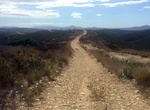
Hike or Ride West Sycamore South Trail, Mission Trails Regional Park, California
Hike, mountain bike or equestian West Sycamore South Trail. The trailhead is located at the southern end of West Sycamore Staging Area in Mission Trails Regional Park. It's heads south for 0.78 miles and end at Marine Corps Air Station (MCAS) Miramar. There is a branch at mile 0.43 that heads east fo 0.35 miles. -
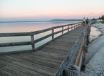
Hike West Thumb Geyser Basin Trail, Yellowstone National Park, Wyoming
The West Thumb Geyser Basin, including Potts Basin to the north, is the largest geyser basin on the shores of Yellowstone Lake. The heat source of the thermal features in this location is thought to be relatively close to the surface, only 10,000 feet (3,000 m) down. West Thumb is about the same size as another famous volcanic caldera, Crater Lake in Oregon, but much ... -
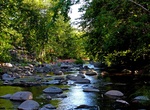
Hike to Wet Beaver Creek, Coconino National Forest, Arizona
This clear, cool brook remains pleasantly secluded in the deep red rock canyon it has cut into the southern rim of the Colorado Plateau. For much of its length, the land bordering Wet Beaver Creek has been declared a Wilderness Area, the Wet Beaver Wilderness. In addition to the opportunities for solitude such an area offers, the stream's pools and riffles are a popul... -
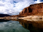
Hike/Kayak Wetherill Canyon, Lake Powell, Utah
Wetherill Canyon is an excellent slot canyon at Lake Powell to explore by kayak and then hike depsding on wagter level. -
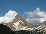
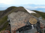
Summit Wetterhorn Peak, San Juan Mountains, Colorado
Wetterhorn Peak is a fourteen thousand foot mountain peak in the U.S. state of Colorado. It is located in the Uncompahgre Wilderness of the northern San Juan Mountains, in northwestern Hinsdale County and southeastern Ouray County, 9 miles (14 km) east of the town of Ouray. It lies 2.75 mi (4.4 km) west of Uncompahgre Peak. Wetterhorn Peak, and its neighbor Matterhorn... -
Summit Whale Peak, Anza-Borrego Desert State Park, California
The difficult 9 mile trail to Whale Peak in Anza-Borrego Desert State Park features beautiful wild flowers and views. -
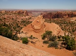
Hike Whale Rock Trail, Canyonlands National Park, Utah
The 1 mile (1.6 km) Whale Rock Trail in Canyonlands National Park is a short climb up Whale Rock leads to views of Upheaval Done and surrounding area. Elevation change: 100 feet / 30 m -
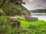
Hike Whangamumu Track, New Zealand
Hike along the 4.2 kmone way path that whalers used to take in the early 20th century to one of New Zealand’s last remaining shore-based whaling stations. Dogs with a DOC permit for recreational hunting or management purposes only. -
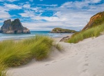
Hike to Wharariki Beach, South Island, New Zealand
Wharariki Beach is a beach west of Cape Farewell, the northernmost point of the South Island of New Zealand. The north-facing sandy beach is accessible only via a 20-minute walking track from the end of Wharariki Road. The road end is approximately 4 kilometres (2.5 mi) from the nearest settlement, the small village of Puponga. A camping ground is located along Wharar... -
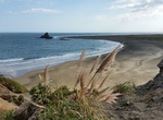
Hike Whatipu-Gibbons Track, New Zealand
The Whatipu-Gibbons Track begins at the carpark at Whatipu, New Zealand. It leads up the hill to the right of the carpark and is clearly marked. It follows the top of the cliffs to the picturesque Pararaha Valley where it descends to the beach at Pararaha point. It then follows the beach back to Whatipu. You need to be fit because the trudge back along the beach is qu... -
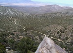
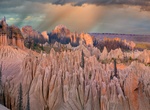
4WD & Hike to Wheeler Geologic Area, Colorado
The Wheeler Geologic Area is a highly eroded outcropping of layers of volcanic ash, in the La Garita Mountains of Mineral County, in southern Colorado in the western United States about 10 miles east north-east of Creede. The ash is the result of eruptions from the La Garita Caldera approximately 25 million years ago. The area was designated a National Monument from 1... -
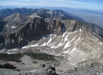
Summit Wheeler Peak, New Mexico
Wheeler Peak is the highest natural point in the U.S. state of New Mexico. It is located northeast of Taos and south of Red River in the northern part of the state, and just 2 miles (3.2 km) southeast of the ski slopes of Taos Ski Valley. It lies in the Sangre de Cristo Mountains, the southernmost subrange of the Rocky Mountains. The peak's elevation is 13,161 feet (4... -
Summit Wheeler Peak, Great Basin National Park, Nevada
Wheeler Peak is the tallest mountain in the Snake Range and in White Pine County, in Nevada, United States. The summit elevation of 13,065 feet (3,982 m) makes it the second-highest peak in Nevada, just behind Boundary Peak. With a topographic prominence of 7,563 feet (2,305 m), Wheeler Peak is the most topographically prominent peak in White Pine County and the secon... -
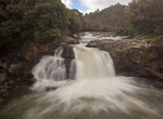
Hike Whinray Scenic Reserve Track (Motu Falls), New Zealand
Whinray Scenic Reserve is a 429 hectare reserve featuring native forest and a spectacular set of waterfalls on the wild and scenic Motu River. The Whinray Scenic Reserve Track is a 6.3 kmone way trail that takes 2-3 hours. Walk across the reserve from the car park on Marumoko Road to the Motu Falls car park. The walk from this end is an easy, downhill gradient and is...
Price: $398.24