Give us feedback!


 See all

Our philosophy is simple. We want to encourage you to dream. BIG! Then we help you plan your trip, get the most out of it while you're traveling and help you share your experience with friends.
Join Now It's FREE
Dream Packages
Duration: 12 hours
Price: $154.81
Price: $154.81
Duration: 4 days
Price: $1026.70
Price: $1026.70
Duration: 10 hours
Price: $199.57
Price: $199.57
Duration: 4 days
Price: $772.57
Price: $772.57
Related Categories
- Australian National Parks & Reserves
- Canadian National Parks
- Canyoneering
- Day Hikes
- Guided Hikes
- In the Mountains
- Mountaineering
- Mountains
- New Zealand Great Walks
- New Zealand National Parks
- Parks & Reserves
- Rock Climbing
- South African National Parks
- UK National Parks
- UNESCO Parks & Preserves
- US Historical Parks (NHP)
Dreams Still To Do
Checked-Off Dreams
Dreams Still To Do
Checked-Off Dreams
Advertisement
Explore Hikes & Treks
-
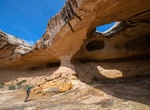
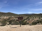
Hike to Wild Horse Window, San Rafael Swell, Utah
Wild Horse Window is a large natural bridge located near Temple Mountain in the Southeastern section of the San Rafael Swell near Goblin Valley State Park. It's a fairly short hike and should be enjoyable for all ages. Not to be confused with Little Wild Horse Canyon, famous for a narrow slot canyon hike. -
Go on Wildlife Tracking Walk (Mission Trails), San Diego, California
Join experienced MTRP Tracking Team members Mike Gibbs and Bob MacDonald for an adventure in wildlife tracking on the Oak Grove Loop Trail. Learn the art of discovering and identifying tracks and other signs left behind by the park’s seldom-seen wildlife. These easy walks are suitable for the whole family. Walks start from the front of the Visitor Center on... -
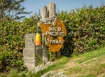
Hike Wild Pacific Trail, Vancouver Island, BC, Canada
This 8 kilometre trail can be walked in two main sections: Lighthouse Loop (2.6 km loop) plus Terrace Beach Interpretive Trail (.5 km one way) Big Beach to Rocky Bluffs (5 km one way) plus Ancient Cedars Trail (1 km loop) -
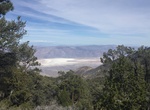
Hike to Wildrose Peak, Death Valley National Park, California
Wildrose Peak offers cooler temperatures, beautiful views, and pinyon-juniper forest. It's 8.4 mile round-trip hike to the summit.Gorgeous view are at 1.7 miles from the trailhead. Make this your destination and enjoy the shade of pinyon pines as you soak up the view. And get a mountain-top-worthy view with a 3.4 mile round-trip hike! -
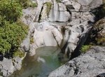
Hike to Wilkies Pools, Egmont National Park, New Zealand
The first 400 m of this track is baby buggy/wheelchair friendly. Starting above the visitor centre, the track winds through ‘goblin forest’, crossing the unbridged Kapuni Stream (impassable after heavy rain) to reach the turnoff to the small lava formed Wilkies Pools. These pools were named after the Wilkies brothers who farmed locally. Return to the signp... -
Hike to Willet's Well Homestead Ruins & Car, Joshua Tree National Park, California
A little east of Samuelson Rocks is an old homestead and rusty car. -
Hike to William L. Kenyon Overlook Trail (Bill Kenyon Trail), Anza-Borrego Desert State Park, California
The hike to Bill Kenyon Overlook is a little difficult to follow but offers a nice viewpoint that overlooks Mescal Bajada, San Felipe Wash and Pinyon Mountains. You can start this loop from two points, Yaqui Pass Primitive Campground and a second roadside trailhead along Yaqui Pass Road. -
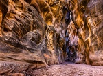
Hike Willis Creek Slot Canyon, Utah
Willis Creek is located in Grand Staircase-Escalante National Monument in southern Utah. The creek runs through a wash which in some sections narrows to become a slot canyon. The creek is popular with hikers as the stream is generally 1-2 inches deep and a trail runs the length of the creek. The end of the creek is dry. Use Skutumpah Road, also known as BLM 500, to ge... -
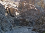
Hike Willow Canyon, Death Valley National Park, California
Willow Canyon trail is a 4.2 miles (6.8km) out and back hike in Death Valley National Park. route isn't very physically demanding, but finding the canyon and seasonal waterfall is a reward that only cross country navigators get to enjoy. No road and no hiking route signage. From the parking area avoid the small foothills and canyons to the east. Instead make your way ... -
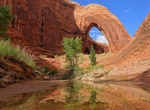
Hike Willow Gulch to Broken Bow Arch, Utah
The spectacular Broken Bow Arch is located in Willow Gulch in Utah. Hike approximately one mile downstream from the Willow Gulch trailhead off Hole-in-the-Rock Road. It is named after a Native American artifact found nearby. The opening is estimated at 94 feet (29 m) wide and 100 feet (30 m) high, demonstrating the arch-forming ability of Navajo sandstone. -
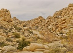
Hike to Willow Hole, Joshua Tree National Park
Willow Hole is a tiny oasis amid fantastic rock formations in Wonderland of Rocks. It's reached via 7-mile roundtrip hike from the Boy Scout Trailhead. Mostly flat trail along the edge of the Wonderland of Rocks. Travel through Joshua tree forests, boulder landscape, and sandy washes. Trail ends at willow trees. -
Hike Wills-Rice Loop at Ventura River Preserve, Ojai, California
Ventura River Preserve, Wills-Rice Loop is about 5.2 miles long and located near Ojai, California. The trail is great for hiking and normally takes two or three hours. The Ventura River Preserve is maintained by the Ojai Valley Land Conservancy. It contains a vast network of trails along the Ventura River and into the adjoining foothills. One can choose between easy, ... -
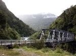
Hike Wills Valley Track, Mount Aspiring National Park, New Zealand
This track is for experienced trampers and starts at the Gates of Haast Bridge. Like most of the smaller valleys in this area, the Wills’ lower reaches are gorged, and then open out to flats further up. -
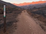
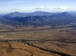
Explore Wilpena Pound, South Australia
Wilpena Pound is a natural amphitheatre of mountains located 429 kilometres (267 mi) north of Adelaide, South Australia, Australia in the heart of the Flinders Ranges National Park. The Pound is the most northern point with access via a sealed road in this part of the Flinders Ranges. The closest town to the north is Blinman and to the south, Hawker. The Pound is a ve... -
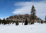
See Wilson Butte, Mammoth Lakes, California
Wilson Butte is a 8,405 ft / 2,562 m lava dome located north of Mammoth Lakes, California along Hwy 395. The lava dome is composed of gray rhyolite, frothy pumice, and black obsidian. There is no designated trail to the top.


Price: $263.77