Give us feedback!


 See all

Our philosophy is simple. We want to encourage you to dream. BIG! Then we help you plan your trip, get the most out of it while you're traveling and help you share your experience with friends.
Join Now It's FREE
Dream Packages
Duration: 4 hours
Price: $129.99
Price: $129.99
Duration: 4 days
Price: $1026.70
Price: $1026.70
Duration: 14 hours
Price: $341.00
Price: $341.00
Duration: 4 days
Price: $663.61
Price: $663.61
Related Categories
- Australian National Parks & Reserves
- Canadian National Parks
- Canyoneering
- Day Hikes
- Guided Hikes
- In the Mountains
- Mountaineering
- Mountains
- New Zealand Great Walks
- New Zealand National Parks
- Parks & Reserves
- Rock Climbing
- South African National Parks
- UK National Parks
- UNESCO Parks & Preserves
- US Historical Parks (NHP)
Dreams Still To Do
Checked-Off Dreams
Dreams Still To Do
Checked-Off Dreams
Advertisement
Explore Hikes & Treks
-
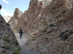
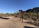
Hike or Mountain Bike Wilson Canyon, Nevada
Wilson Canyon is a gorge cut by the Walker River through a series of volcanic cliffs. The canyon is located 13 miles (21 km) west of Yerington, along Nevada State Route 208. It is managed by the U.S. Bureau of Land Management. The canyon runs through the Singatse Range in Lyon County, where the Walker River flows northeast into the Mason Valley. Over the two miles (3.... -
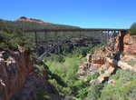
Hike Wilson Canyon Trail, Sedona, Arizona
This trail begins at the picnic ramada just up the old roadway from the Midgley Bridge parking area. At 0.1 miles, bear right onto the trail marked by large rock cairns. It gradually climbs, then descends to the normally dry canyon drainage. At 0.6 miles, past the fork to the right signed for the Wilson Mountain Trail and then the fork to the left signed for the Jim T... -
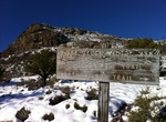
Hike Wilson Mountain Trail, Sedona, Arizona
Wilson Mountain is 7,122 feet tall and named after Richard Wilson. Richard Wilson was a bear hunter who was killed by a grizzly in 1885. His body was found in Wilson Canyon, which is also named after him. This is the tallest mountain around Sedona, Arizona. The trail to the summit leads to an absolute killer-view of Sedona and far beyond, of Oak Creek, and even of the... -
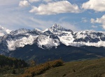
Summit Wilson Peak, San Juan Mountains, Colorado
Wilson Peak is a 14,023-foot (4,274 m) mountain peak in the U.S. state of Colorado. It is located in the Lizard Head Wilderness of the Uncompahgre National Forest, in the northwestern San Juan Mountains. It is the highest point in San Miguel County. The mountain was named for A.D. Wilson, the chief topographer with the Hayden Survey. Nearby Mount Wilson also honors hi... -
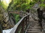
Hike Wimbachklamm, Berchtesgaden National Park, Germany
An elevated walkway runs through this scenic gorge where multiple waterfalls cascade into a river. -
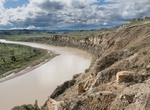
Hike Wind Canyon Trail, Theodore Roosevelt National Park, North Dakota
Enjoy hiking this nature trail alongside a wind-sculpted canyon as you climb to the best view of the Little Missouri River the South Unit has to offer. Another ranger favorite for sunsets! -
Hike Wind Cave Canyon Trail, Wind Cave National Park, South Dakota
The trail begins on the east side of Hwy 385 one mile north of the southern access road to the Visitor Center. This easily walked trail follows Wind Cave Canyon to the park boundary fence. Wind Cave Canyon is one of the best places in the park for bird watching. Limestone cliffs provide good nesting areas for cliff swallows and great horned owls. Standing dead trees s... -
Hike to Wind Caves, Anza-Borrego Desert State Park, California
One of the first stops along Fish Creek in Anza-Borrego Desert State Park are the Wind Caves. It's a 1-mile hike to the caves and is well worth it. -
Hike Wind Cave Trail, Usery Mountain Regional Park, Arizona
The Wind Cave Trail, that reaches high onto the mountain side and allows hikers onto the adjacent Tonto National Forest. -
Summit Windom Peak, Needle Mountains, Colorado
Windom Peak is the highest summit of the Needle Mountains range of the Rocky Mountains of North America. The prominent 14,093-foot (4,296 m) fourteener is located in the Weminuche Wilderness of San Juan National Forest, 28.2 miles (45.4 km) northeast by north (bearing 32°) of the City of Durango in La Plata County, Colorado, United States. The summit of Windom Pea... -
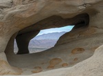
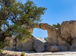
Hike Window Arch Trail, City of Rocks National Reserve, Idaho
Located behind campsite 37, this short walk leads to the impressive Window Arch which spans over 20 feet. Windows, bathtubs, and caves sculpted by forces of erosion, are featured here along with spectacular views of the “Inner City”. -
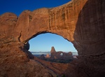
Explore Windows Section, Arches National Park, Utah
The Windows Section in Arches National Park has a series of scenic arches are located in close proximity in this area, along with pinnacles and other interesting rock formations. -
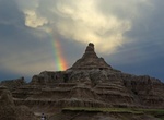
Hike Window Trail, Badlands National Park, South Dakota
This short trail leads to a natural window in the Badlands Wall with a view of an intricately eroded canyon. Please stay on the trail. -
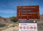
Hike Window Trail, Big Bend National Park, Texas
This trail descends through Oak Creek Canyon to the Window pour-off which frames panoramic desert vistas. During wetter periods Oak Creek may be flowing, and must be crossed several times. Use caution on this trail: the top of the Window pour-off is slickrock with no railings, and the return hike is uphill. Begin at the Chisos Basin Trailhead. -
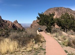
Hike Window View Trail, Big Bend National Park, Texas
Window View Trail is a 0.3 mile loop trail located at the Chisos Basin Visitor Center in Big Bend National Park. This easy, paved wheelchair accessible trail circles a low hill with excellent views of the mountain peaks surrounding the Chisos Basin, and a view through the window. Benches along the trail offer a place to sit and enjoy a classic Big Bend sunset.

Price: $606.00