Give us feedback!


 See all

Our philosophy is simple. We want to encourage you to dream. BIG! Then we help you plan your trip, get the most out of it while you're traveling and help you share your experience with friends.
Join Now It's FREE
Dream Packages
Duration: 4 hours
Price: $129.99
Price: $129.99
Duration: 6 days
Price: $606.00
Price: $606.00
Duration: 2 days
Price: $398.24
Price: $398.24
Duration: 12 hours
Price: $263.50
Price: $263.50
Related Categories
- Australian National Parks & Reserves
- Canadian National Parks
- Canyoneering
- Day Hikes
- Guided Hikes
- In the Mountains
- Mountaineering
- Mountains
- New Zealand Great Walks
- New Zealand National Parks
- Parks & Reserves
- Rock Climbing
- South African National Parks
- UK National Parks
- UNESCO Parks & Preserves
- US Historical Parks (NHP)
Dreams Still To Do
Checked-Off Dreams
Dreams Still To Do
Checked-Off Dreams
Advertisement
Explore Hikes & Treks
-
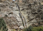
Hike Falls Canyon, White Mountains, California
The west side of the White Mountains is separated from Owens Valley by the White Mountains fault zone. The most rapid vertical displacement in this zone has been happening along the northwest edge of the range, rendering most of the drainages there impassably steep without technical equipment and skills. Falls Canyon is one of the more visible examples, but attempts t... -
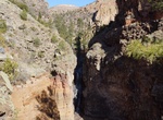
Hike Falls Trail, Bandelier National Monument, New Mexico
The Falls Trail starts at the end of the Backpacker's Parking Lot near the visitor center. The trail descends 400 vertical feet in its 1.5 mile length to the Upper Falls. A beautiful trail in any season, this trail is not cleared of snow in the winter and can be extremely icy. There are steep dropoffs along the trail and plank bridges across the creek. Keep children c... -
Go on Family Discovery Walk (Mission Trails), San Diego, California
Join MTRP Trail Guides Marcia Stoner and Rosalie Newberg-Fisher on a Family Nature Walk and help your children discover the wonder and beauty of Nature! These walks highlight the many changes that occur in the park throughout the year. Summer is when many plants in the park become dormant, but others continue to thrive. Numerous birds and other animals are still... -
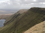
Explore Fan Brycheiniog, Brecon Beacons National Park, Wales
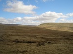
Fan Brycheiniog is the highest peak at 2633 feet (just over 800 m) in the Black Mountain (Y Mynydd Du) region of the Brecon Beacons National Park in southern Wales. There is a trig point at the peak and on the edge of the escarpment, and nearby, a stone shelter with an inner seat. It is just inside the county of Powys, formerly Brecknockshire, the Welsh name of which ... -
Hike Fan Fawr, Brecon Beacons National Park, Wales
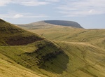
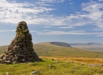
Fan Fawr (Welsh 'big peak') is a mountain in the Fforest Fawr section of the Brecon Beacons National Park, in Powys, Wales and over 734 m (2,408 ft) high. The summit overlooks the steep eastern face and is marked by a cairn. Unusually, the trig point on this hill does not sit at the summit but 600 m to the south-west on a subsidiary spur. The hill is drained to the we... -
Explore Fan Gyhirych, Brecon Beacons National Park, Wales
Fan Gyhirych is a mountain in the Fforest Fawr section of Brecon Beacons National Park in south Wales. It lies within the county of Breconshire, and administered as part of the unitary authority of Powys. Its highest point at 2379 feet (or 725 m) is marked by a trig point which is located towards the western side of the summit plateau. The hill drains to the north int... -
Hike Fan Nedd, Brecon Beacons National Park, Wales
Fan Nedd is a mountain in the Fforest Fawr area of the Brecon Beacons National Park in Wales. In common with the rest of the Fforest Fawr uplands it is within the county of Powys. The hill is in the form of a broad flat-topped ridge whose summit lies at 663 m (2175 ft) and is crowned by a trig point. Its southern ridge is the least steep whereas its northern aspect is... -
Summit Fansipan, Vietnam
Fansipan is a mountain in Vietnam, the highest in Indochina (comprising Vietnam, Laos, and Cambodia), at 3,143 metres (10,312 ft). It is located in the Lào Cai Province of the Northwest region of Vietnam, 9 km southwest of Sa Pa Township in the Hoang Lien Son mountain range. Fansipan is dubbed "the Roof of Indochina" and has about 2,024 floral varieties and 327... -
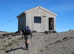
Hike to Fanthams Peak/Panitahi and Syme Hut, Egmont National Park, New Zealand
Perched on the top of Fanthams Peak high on the slopes of Mt Taranaki, Syme Hut is arguably Egmont National Park's best overnight spots. On fine days you can enjoy spectacular views of the Taranaki region followed by stunning sunsets. Known as Panitahi by Māori, Fanthams Peak was named after Fanny Fantham who was the first European woman to climb the peak in 1887. T... -
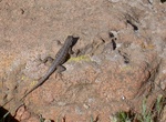
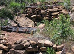
Hike Farming Terrace Trail, Mesa Verde National Park, Colorado
Beginning and ending on the spur road to Cedar Tree Tower, this 1/2 mile loop leads to a series of prehistoric check dams built by the Ancestral Puebloans to create farming terraces. This trail is a good place to look for lizards, hummingbirds, and a wide variety of plants. -
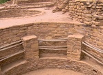
Hike Far View Sites Trail, Mesa Verde National Park, Colorado
Far View was one of the most densely populated parts of the mesa from A.D. 900 to about A.D. 1300. Nearly 50 villages have been identified within a half square mile area, and were home to hundreds of people. Today, several excavated and stabilized sites are linked by a trail system within a short walking distance. These surface sites include Far View House, Pipe Shrin... -
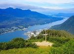
Hike to Father Brown Cross (Mount Roberts), Juneau, Alaska
From the top of the Mount Roberts Tramway it's one-mile loop that goes up 500 feet to Father Brown's Cross. -
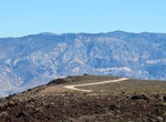
Hike or Off-road to Father Crowley Vista, California
Father Crowley Vista Trailhead is located Father Crowley Overlook along Route 190, near Independence, California. The 1.2 mile out and back trail offers scenic views. -
Hike or Ride Father Juniper Serra Trail, Mission Trails Regional Park, California
Hike or ride the 1.8 mile Father Juniper Serra Trail in Mission Trails Regional Park. Cars are allowed on this road (one-way from visitor center to Old Dam). -
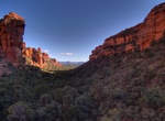
Hike Fay Canyon Trail, Red Rock-Secret Mountain Wilderness, Arizona
Fay Canyon Trail is relatively flat that starts out good and keeps getter better the further you make your way back into this box canyon. It's 2.4 miles roundtrip and takes 1 to 1 1/2 hours. There is a free-standing arch in the canyon; once you hike up into it you can see that the there's a few feet of clearance between it and the wall behind it. From Sedona take Dr...
Price: $1026.70