Give us feedback!


 See all

Our philosophy is simple. We want to encourage you to dream. BIG! Then we help you plan your trip, get the most out of it while you're traveling and help you share your experience with friends.
Join Now It's FREE
Dream Packages
Duration: 2 days
Price: $398.24
Price: $398.24
Duration: 8 hours
Price: $214.32
Price: $214.32
Duration: 4 days
Price: $1457.59
Price: $1457.59
Duration: 4 days
Price: $772.57
Price: $772.57
Related Categories
- Australian National Parks & Reserves
- Canadian National Parks
- Canyoneering
- Day Hikes
- Guided Hikes
- In the Mountains
- Mountaineering
- Mountains
- New Zealand Great Walks
- New Zealand National Parks
- Parks & Reserves
- Rock Climbing
- South African National Parks
- UK National Parks
- UNESCO Parks & Preserves
- US Historical Parks (NHP)
Dreams Still To Do
Checked-Off Dreams
Dreams Still To Do
Checked-Off Dreams
Advertisement
Explore Hikes & Treks
-
Hike Fayetteville Trail, New River, West Virginia
This trail connects Fayette Station Road, the town of Fayetteville, and Kaymoor Top with hiking access to Long Point. Be prepared for a creek crossing and up and down terrain. Connections can be made to the following trails: Kaymoor, Bridge, Park Loop, Timber Ridge, Long Point, Butcher Branch, Kaymoor Miners, and Craig Branch.To reach the Wolf Creek Trailhead:Turn off... -
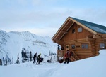
Hike to Fay Hut, Kootenay National Park, Canada
The Fay hut was an alpine hut located above Prospectors Valley in Kootenay National Park, British Columbia. Although the higher Neil Colgan hut superseded it as a base for climbs in the Valley of the Ten Peaks area, it still served as a convenient base for hikers and skiers doing day trips in the area, and as an overnight stop for mountaineers continuing on to the Nei... -
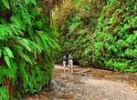
Hike Fern Canyon Loop Trail, Prairie Creek Redwoods State Park, California
To access the area beyond Gold Bluffs Entrance Station, we require Online Day-Use reservations that need to be made in advance. We started it during the summer season of 2022 and are continuing this season 2023 and beyond. The soonest someone can book a reservation is at 11:59 PM the day before. Reservations are required May-September. For the 2023 season it’s f... -
Hike Fern Falls Trail, Oregon
Fern Falls Trail is a 3.9 mile out and back trail that winds along the south bank of the North Umpqua River trail through old-growth forests of Douglas-fir, hemlock, and sugar pine, with trees often over six feet in diameter. -
Hike Fern Lake Trail, June Lake, California
Fern Lake is a short scenic day hike in the June Lake area. The lead the way and views of June and Gull Lakes. At one mile, stay right at the Yost Creek Trail Junction and continue on another 0.7 miles to Fern Lake. -
Summit Festvågtind, Henningsvær, Norway
The hike starts with the parking lot in Festvag. Walk 100 m in direction Henningsvaer, take a turn to the right and follow the trail. From the road, it looks impossibly steep, but the route to the summit wraps around the mountain and never becomes too steep. -
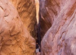
Go on Guided Tour of Fiery Furnace, Arches National Park, Utah
NOTE: Fiery Furnace is temporarily closed. No ranger-led tours nor self-guided permits will be issued until further notice. The Fiery Furnace is a collection of narrow sandstone canyons, sandstone cliffs and monoliths in Arches National Park in Utah, USA. There are no marked trails and the area has suffered resource damage due to increased visitation. Hikers who want ... -
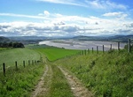
Hike Fife Coastal Path, Scotland
The Fife Coastal Path is a Scottish long distance footpath that runs from Kincardine to Newburgh. The path was created in 2002, originally running from North Queensferry to Tayport. It was extended in 2011 with a new section running from Kincardine to North Queensferry, then again in 2012 from Newburgh to Tayport. It runs for 117 miles (188 km) along the coastline of ... -
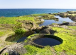
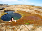
Hike to Figure 8 Pool, Royal National Park Trail, New South Wales
Figure Eight Pools is located in Royal National Park, near Burning Palms Beach. This coastal rock shelf is dotted with natural rockpools – including one in the shape of a figure eight. But don't underestimate the power of the ocean – the rock platform is extremely hazardous and a visit to this popular spot is only possible at low tide and in flat surf cond... -
Hike to Figure 8 Pools, Royal National Park, Sydney, Australia
Figure Eight Pools is located on a dangerous rock shelf in Sydney's Royal National Park. Only accessible about two hours either side of low tide, they are found on the rock platform two headlands south of Burning Palms Beach Also plan your trip using the wave risk forecast. It’s a long, hard 6-9km walk on a steep, narrow, slippery track in a remote area and tak... -
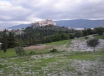
Explore Filopappou Hill, Athens, Greece
Filopappou Hill offers views of Athens & the Acropolis attract hikers to this small peak with an ancient monument. -
Hike Fimmvörðuháls Pass, Iceland
Fimmvörðuháls ("five cairns pass") is the area between the glaciers Eyjafjallajökull and Mýrdalsjökull in southern Iceland. The route between Skógar and Thórsmörk goes through this pass and is one of the most popular walking routes in Iceland, despite being 22 km long and involving 1,000 m of climbing. At Fimmvö... -
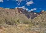
Hike Finger Rock Trail, Tucson, Arizona
As you look toward the Santa Catalinas from metropolitan Tucson, one of the most distinctive landmarks on the Pusch Ridge skyline resembles a closed hand with the index finger extended to make a #1 sign. This is Finger Rock, a 100 foot high formation that marks the steep canyon that bears its name. Finger Rock Canyon offers one of the most direct routes into the Catal... -
Hike to Fire Canyon Arch, Valley of Fire State Park, Nevada
The Fire Canyon Arch is a beautifully colored sandstone formation located in the Fire Canyon portion of the Valley of Fire State Park. It can be reached by the Rainbow Vista Trail. Distance: 1.1 miles out-and-back How to Get There: From Valley of Fire Hwy, take a left on Mouse's Tank Rd and drive approximately 2 miles to reach the Rainbow Vista trailhead. About halfwa... -
Hike to Fire Wave, Valley of Fire State Park, Nevada
Take this short, accessible trail to get to one of the most stunning sandstone formations in the park: the fire wave. An easy 1.25-mile roundtrip trail winds through the reds and oranges of Aztec sandstone. To preserve this fragile and unique area, please stay on the trail, and do not walk on the wave formation at the end of the trail. Distance: 1.25 miles round-tri...


Price: $224.21