Give us feedback!


 See all

Our philosophy is simple. We want to encourage you to dream. BIG! Then we help you plan your trip, get the most out of it while you're traveling and help you share your experience with friends.
Join Now It's FREE
Dream Packages
Duration: 12 hours
Price: $263.50
Price: $263.50
Duration: 2 days
Price: $398.24
Price: $398.24
Duration: 4 days
Price: $772.57
Price: $772.57
Duration: 6 days
Price: $606.00
Price: $606.00
Related Categories
- Australian National Parks & Reserves
- Canadian National Parks
- Canyoneering
- Day Hikes
- Guided Hikes
- In the Mountains
- Mountaineering
- Mountains
- New Zealand Great Walks
- New Zealand National Parks
- Parks & Reserves
- Rock Climbing
- South African National Parks
- UK National Parks
- UNESCO Parks & Preserves
- US Historical Parks (NHP)
Dreams Still To Do
Checked-Off Dreams
Dreams Still To Do
Checked-Off Dreams
Advertisement
Explore Hikes & Treks
-
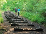
Hike Forest of Dean Sculpture Trail, Gloucestershire, England
The Forest of Dean Sculpture Trail is a point of interest in the Forest of Dean in the county of Gloucestershire, England. The Sculpture Trail links several different site-specific sculptures commissioned for the forest. It is open from dawn to dusk every day of the year, with no admission charge. There are currently 16 sculptures, made from various materials. A furth... -
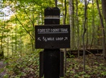
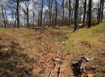
Hike Forest Point Trail, Cuyahoga Valley National Park, Ohio
Forest Point Trail is a easy half-mile and should take up to 30 minutes to trek. -
Hike Forest Walk, Telok Blangah Hill Park, Southern Ridges, Singapore
NOTE: Forest Walk is closed from 17 January 2025. Please use alternative route along Depot Road or use the entrance opposite Block 88A along Telok Blangah Heights Forest Walk is a 1.3-kilometre-long (0.81 mi) walkway that cuts through about 50 metres (160 ft) through the secondary forest in Telok Blangah Hill Park and connects to Alexandra Arch. The raised walkway wit... -
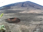
Hike Formica Leo, Réunion, France
Formica Leo, named for its similar shape to the pitfall built by the antlion, is a small volcanic crater of the Piton de la Fournaise (French for "Peak of the Furnace"), the active volcano on the eastern side of Réunion island (a French department) in the Indian Ocean. It is located at the bottom of the caldera called Enclos Fouqué, just beneath the moun... -
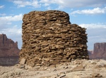
Hike to Fort Bottom Ruin, Canyonlands National Park, Utah
Constructed roughly 1,000 years ago, Fort Bottom Ruin remains one of the more dramatic reminders of ancestral Puebloan culture along the Green River. It is located near Hardscrabble Camp on the White Rim Road in Canyonlands National Park, Utah. The trial is 3-4 miles round trip (has a few different sources). -
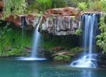
Hike to Fortescue Falls & Fern Pool, Karijini National Park, Western Australia
Hike down (800 metres, 2-hour return walk.) through the changing vegetation of the iron-rich gorge walls to the park's only permanent waterfall. Here you can have a refreshing swim in the spring fed permanent falls. In the cooler months (April-September) the water can be very cold. -
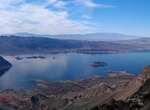
Hike Fortification Hill, Arizona
An extinct-volcano-gone-mesa, Fortification Hill is a 3,719-foot prominence that overlooks Lake Mead and the Hoover Dam. The trailhead is close to Willow Beach and is rated as difficult. Though most of the hike is fairly straightforward, there is a stretch where the trail becomes unstable. The trail is most popular in the Springtime when the flowers bloom on the mesa.... -
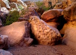
Hike Fortknocker Canyon, Utah
Fortknocker Canyon is a tributary of Utah's White Canyon near UT 95 between mileposts 59 and 60, about 4 miles south of the Black Hole. It has rocks of varying shades of red, pink and grey. -
Hike Fort Lyon Trail, Kentucky
The ruins of Fort Lyon, a Civil War era earthen fort, are still visible to visitors touring Cumberland Gap National Historical Park. Located at the end of the Pinnacle Road. -
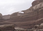
Hike to Fortress Arch & Castle Arch, Canyonlands National Park, Utah
Castle Arch in Canyonlands National Park has only a thin sliver of sandstone. Fortress Arch is about as different from the nearby Castle Arch as two arches can be. It's big and bulky with over 150 feet of sandstone above the opening. The trailhead is on Horse Canyon Road. -
Hike to Fort Serapong, Sentosa Island, Singapore
Fort Serapong is a former coastal artillery battery on Mount Serapong hill on Sentosa Island in Singapore, then known as Pulau Blakang Mati. It was one of four major batteries on the island, along with Fort Siloso, Fort Connaught and the Mount Imbiah Battery. Approval for a battery on Mount Serapong hill was granted by the British in the early 1880s, with the battery ... -
Hike Fort to Sea Trail, Oregon
The "Fort to Sea Trail" follows the 6.5 mile route used by the Lewis and Clark Expedition when hiking from Fort Clatsop to the Pacific Ocean, ends at Sunset Beach. Explore the forests, travel along the coastal rivers and lakes, and traverse the coastal dunes. The Fort To Sea Trail starts from the Visitor Center at Fort Clatsop. The first two miles take you up a gentl... -
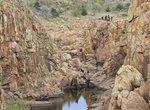
Hike to Forty Foot Hole, Wichita Mountains Wildlife Refuge, Oklahoma
Forty Foot Hole is a canyon formed by West Cache Creek in the Wichita Mountains Wildlife Refuge in Oklahoma. After exiting Forty Foot Hole, the creek flows on a plain for half a mile before entering another canyon known as The Narrows. -
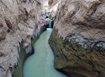
Hike Fortymile Gulch & Willow Gulch, Utah
Fortymile Gulch and Willow Gulch are tributaries of the Escalante River, located in Kane County in southern Utah, in the western United States. With a combined length of over 20 miles (30 km), they exhibit many of the geologic features found in the Canyons of the Escalante, including high vertical canyon walls, water pools, narrow slot canyons, domes, and arches. Popu... -
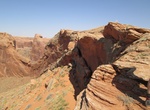
Hike Fortymile Ridge to Crack in the Wall into Coyote Gulch, Utah
One of the best ways to hike into Coyote Gulch is via the Crack in the Wall. There are outstanding views from the canyon rim by hiking from Fortymile Ridge to Crack-in-the-Wall. After scrambling down through the crack - a narrow route between the cliff face and huge rock slabs which have peeled off the cliff - a trail leads down a steep sand dune to lower Coyote Gulch...
Price: $224.21