Give us feedback!


 See all

Our philosophy is simple. We want to encourage you to dream. BIG! Then we help you plan your trip, get the most out of it while you're traveling and help you share your experience with friends.
Join Now It's FREE
Dream Packages
Duration: 12 hours
Price: $263.50
Price: $263.50
Duration: 10 hours
Price: $199.57
Price: $199.57
Duration: 4 hours
Price: $149.99
Price: $149.99
Duration: 2 days
Price: $398.24
Price: $398.24
Related Categories
- Australian National Parks & Reserves
- Canadian National Parks
- Canyoneering
- Day Hikes
- Guided Hikes
- In the Mountains
- Mountaineering
- Mountains
- New Zealand Great Walks
- New Zealand National Parks
- Parks & Reserves
- Rock Climbing
- South African National Parks
- UK National Parks
- UNESCO Parks & Preserves
- US Historical Parks (NHP)
Dreams Still To Do
Checked-Off Dreams
Dreams Still To Do
Checked-Off Dreams
Advertisement
Explore Hikes & Treks
-
Hike Fremont Gorge Overlook Trail, Capitol Reef National Park, Utah
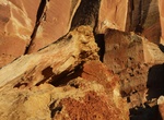
The 2.3 mi (3.6 km) Fremont Gorge Overlook Trail in Capitol Reef National Park is a Strenuous short hike with 1,090 ft (332 m) elevation gain. The climb opens up on a mesa, ends at high viewpoint on rim of gorge. -
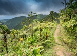
Hike Fremont River Trail, Capitol Reef National Park, Utah
The short 1.0 mi (1.7 km) Fremont River Trail in Capitol Reef National Park is an easy stroll along the Fremont River, then a steep climb to panoramas of the valley. It has a elevation gain of 480 ft (146 m). -
Summit Frenchmans Cap, Tasmania, Australia
Frenchmans Cap is a prominent mountain in the Franklin-Gordon Wild Rivers National Park, Western Tasmania, Australia. It lies east of the West Coast Range, and south-west of the Cradle Mountain-Lake St Clair National Park. It was well known to Aborigines, and one of its names was Mabarlek. The walk to the peak along the well marked track typically takes two days. The ... -
Hike or Rock Climb Frenchman’s Peak, Cape Le Grand National Park, Western Australia
Rock-climbing is popular at Frenchman’s Peak in Cape Le Grand National Park, Western Australia. There is a hard 3km (2 hour) loop hike to the summit to enjoy outstanding views over the coast. This popular climb as it's not too hard to reach the 262m summit, though a reasonable amount of fitness and balance is needed to traverse the constant incline and scamper o... -
Hike Freshwater Lake to Boeri Lake, Morne Trois Pitons National Park, Dominica
The Boeri Lake is the highest lake in Dominica at an altitude of 2,850 ft. (869 m) and is often shrowded in mist. The ridge hike to Boeri Lake for some superb panoramic views of Dominica. The hike from Freshwater Lake to Boeri Lake is 4.2 miles (6.75 km). -
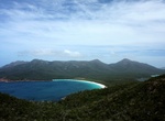
Hike Freycinet Experience Walk, Tasmania, Australia
The original and award winning Freycinet Experience Walk is a four-day guided walk covering the entire length of the Freycinet Peninsula on Tasmania’s East Coast, including the iconic Wineglass Bay. Walk beaches of powder white sand, hike pink granite mountains and discover forests of towering white gums where you and your walking companions, maximum 10, feel li... -
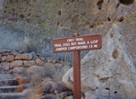
Hike Frey Trail, Bandelier National Monument, New Mexico
Prior to the construction of the modern entrance road, the Frey Trail was the only access to the canyon. Originally, the parking lot was at the canyon rim. Today, it starts at the campground amphitheater. The trail is 1.5 miles (2.4 km) one way. There is an elevation change of 550 feet (170 m). Restrooms and drinking water near trailhead at the visitor center and cam... -
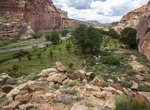
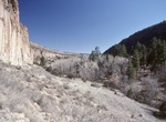
Hike Frijoles Canyon and Rim Loop Trail, Bandelier National Monument, New Mexico
The Mid Frijoles canyon trail is a very popular 8 mile one way hike from Ponderosa group campground to the Visitor Center. This trail has just been rebuilt after the Conchas fire and subsequent flooding, and is now in great condition. From Ponderosa campground he trail descends into the canyon bottom and turns left along the creek and canyon bottom towards the Visitor... -
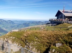
Visit Fronalpstock Hotel | Restaurant, Fronalpstock, Stoos, Switzerland
Fronalpstock Hotel & Restaurant is located in Stoos, 6306 feet above sea level and next to the 4er Sesselbahn Fronalpstock and 6er Sesselbahn. Located amid the Ski Region Stoos, the inn is only accessible by foot or via the cable car. At the inn the rooms are equipped with a terrace. With a private bathroom, some rooms at Fronalpstock Hotel & Restaurant also f... -
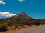
Summit Froze-to-Death Mountain, Montana
Froze-to-Death Mountain is a prominent summit among the Beartooth Mountains. It stands in Stillwater County, Montana, United States. Froze-to-Death Mountain rises to an elevation of 11,755 feet (3,583 m) at its peak. It is the highest landform in the Froze-to-Death Plateau, a local name for an area within the Beartooth Mountains. Surrounding features include Froze-to-... -
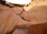
Canyoneer Fry Canyon, Utah
Fry Canyon is a nice little slot canyon next to Utah State Route 95. It's good for begineer canyoneers and offers has pools, Native American ruins, and a fantastic slot sections. Note that the water can get pretty putrid if it has not rained in awhile. -
Hike Frying Pan Trail, Capitol Reef National Park, Utah
The Frying Pan Trail in Capitol Reef National Park is a strenuous 2.9 mi (4.6 km) hike with a 810 ft (247 m) elevation gain that connects Cohab Canyon and Cassidy Arch trails and has ridgetop panoramas of the park. -
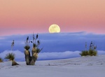
Go on Full Moon Guided Hike, White Sands National Monument, New Mexico
Have you ever wanted to hike the dunes under the magical glow of the full moon? This is your chance to enjoy the peace and serenity of this elusive environment and experience unique stories of the monument. Full moon hikes are offered once a month, April through October, on the night before the full moon. Please see schedule to confirm dates. Offered only once a mont... -
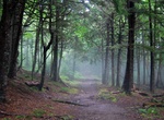
Hike Fundy Footpath, Fundy National Park, Canada
Fundy Footpath is a 49.3 km coastal path along cliffs, old growth forest, beaches, streams and marshes usually takes 3-4 days to cover the well-worn path of rugged, steep switchbacks and grueling descents the width of a hiker's two feet. The trail isn't designed for inexperienced hikers. The total elevation climb is more than 3,000 metres. Distances: Big Salmon R... -
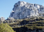
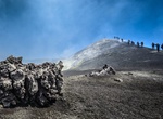
Hike Funivia dell'Etna to Mount Etna, Sicily, Italy
Start at the top of the Funivia dell'Etna gondola station (Sapienza Refuge ski area) and hike to Mount Etna. Lying at the south of the crater at elevation of 1910 m. From the Refuge, a cableway runs uphill to an elevation of 2500 m, from where the crater area at 2920 m is accessible.
Price: $469.00