Give us feedback!


 See all

Our philosophy is simple. We want to encourage you to dream. BIG! Then we help you plan your trip, get the most out of it while you're traveling and help you share your experience with friends.
Join Now It's FREE
Dream Packages
Duration: 4 days
Price: $663.61
Price: $663.61
Duration: 10 hours
Price: $199.57
Price: $199.57
Duration: 4 hours
Price: $129.99
Price: $129.99
Duration: 30 minutes
Price: $263.77
Price: $263.77
Related Categories
- Australian National Parks & Reserves
- Canadian National Parks
- Canyoneering
- Day Hikes
- Guided Hikes
- In the Mountains
- Mountaineering
- Mountains
- New Zealand Great Walks
- New Zealand National Parks
- Parks & Reserves
- Rock Climbing
- South African National Parks
- UK National Parks
- UNESCO Parks & Preserves
- US Historical Parks (NHP)
Dreams Still To Do
Checked-Off Dreams
Dreams Still To Do
Checked-Off Dreams
Advertisement
Explore Hikes & Treks
-
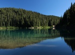
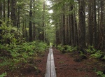
Hike Garibaldi Lake Trail, Garibaldi Provincial Park, BC, Canada
Garibaldi Lake Trail takes hikers to Garibaldi Lake and the corresponding campground. -
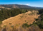
Hike Garland Ranch to Sniveley's Ridge, Garland Ranch Regional Park, Carmel Valley, California
Garland Ranch to Sniveley's Ridge is about 5.9 miles long and located near Carmel Valley Village, California. The trail is great for hiking and normally takes a half day -
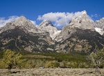
Hike Garnet Canyon, Grand Teton National Park
Garnet Canyon is located in Grand Teton National Park in the U.S. state of Wyoming. The canyon was formed by retreating glaciers which reached their last glacial maximum around 15,000 years ago. While Garnet Canyon is a less popular destination for recreational hikers than nearby Cascade Canyon or Death Canyon, it is an important approach to many significant and popul... -
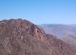
Hike Garnet Peak Trail, Mount Laguna, California
Garnet Peak is located in the Laguna Mountains area of the Descanso District and offers stunning viewpoints at 6000 elevation and an intense workout with a dramatic climbs at the peak. If starting at the Penny Pines Trailhead and hiking through the Pacific Crest Trail (PCT) the Garnet Peak offers a 1.2 mile out-and-back uphill incline as a stand alone trail off of the... -
Hike Garstin & Clara Burgess Trails to Murray Hill, Palm Springs, California
This trail is the only route to the summit of Murray Hill, the prominent conical peak just south of Palm Springs, best seen when heading south on Gene Autry Trail (Highway 111). This is a steep and challenging trail with gorgeous views along the way. You must take other trails to get to the Clara Burgess, all of which require additional gains of elevation. Commonly, i... -
Hike or Ride Garwood Loop, Saguaro National Park, Arizona
Take the Douglas Spring Trail to the Garwood Trail and turn right. You’ll enter the kind of cactus forest that inspired the creation of the parkland here in 1933. Stay on the Garwood Trail all the way south to the Carrillo Trail, taking care at the junctions with Bajada Vista and Wildhorse Trails as it can be confusing for those new to the trail system. At the ... -
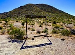
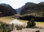
Hike Gates of Lodore Trail, Dinosaur National Monument, Colorado
The trail starts with a few steps and then is a level walk above the Green River. The trail ends at a view of the entrance to Lodore Canyon.Length: ¾ mile one way / 1.5 mile round trip. Not a loop.Level of Difficulty: Easy. The trail is gravel and even terrain for most of the hike.Trailhead Location: Located at the Gates of Lodore Campground at the north end of... -
Hike or Ride Gateway Loop Trail, McDowell Sonoran Preserve, Arizona
A 4.5 mile loop that wanders up to a low saddle before winding back to the Gateway Trailhead. The length and grade changes make this a moderately difficult hike, but one worth trying. Make your way at an enjoyable pace while enjoying the wildflowers and wildlife. Kids with hiking experience may be able to enjoy this hike. Follow the main trail from the parking area t... -
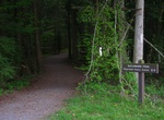
Hike or Ride Gatlinburg Trail, Great Smoky Mountains, Tennessee
The Gatlinburg Trail is one of two walking paths on which visitors can walk dogs and bicycle. Pets and bicycles are prohibited on all other park trails. The trail travels 1.9 miles one-way from the Sugarlands Visitor Center to the outskirts of the city of Gatlinburg, TN. It is relatively flat and runs through the forest along side the West Prong of the Little Pigeon R... -
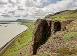
See view from Gaukshöfði, Iceland
It's an easy walk or 4x4 drive up to Gaukshöfði at the top of the hill. Provides great views of the Þjorsárdalur valley. -
Hike Gavan Hill-Harbor Mountain Trail, Sitka, Alaska
The Gavan Hill trailhead is located at the end of Baranof Street. A broad gravel path leads into the forest, where the trail briefly intersects with the Sitka Cross Trail and then cuts straight up the side of Gavan Hill. The ascent is steep – about 2,000 feet in less than 2 miles – and spent mainly on wooden stairs. A mile in, there is a viewing platform t... -
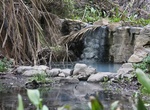
Hike to Gaviota Hot Springs, California
The most heavily traveled trail in Gaviota State Park is a short dirt road leading to a popular hot spring on the eastern side of the highway. Gaviota Hot Springs is more warm than it is hot, but the blue sulfery water attracts its share of bathers. -
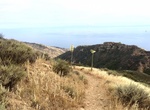
Hike to Gaviota Peak, California
Gaviota Peak is a summit in the Santa Ynez Mountains in Gaviota State Park, located 2 miles (3.2 km) from the Pacific Ocean. The Gaviota Peak Fire Road trail starts near the junction of U.S. Route 101 and California State Route 1, and ends on the summit in the Los Padres National Forest. The trail passes Gaviota Hot Springs, and offers views of the Santa Ynez Mountai... -
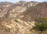
Hike to Gaviota Wind Caves, California
The Gaviota Wind Caves are a sandstone formation located a mile from the Pacific Ocean in Gaviota State Park. The hike to the wind-swept caves is 2.5 miles round trip with 600 feet of elevation gain. -
Walk Gdańsk Royal Road, Poland
The city has some buildings surviving from the time of the Hanseatic League. Most tourist attractions are located along or near Ulica Długa (Long Street) and Długi Targ (Long Market), a pedestrian thoroughfare surrounded by buildings reconstructed in historical (primarily during the 17th century) style and flanked at both ends by elaborate city gates. This part o...


Price: $149.99