Give us feedback!


 See all

Our philosophy is simple. We want to encourage you to dream. BIG! Then we help you plan your trip, get the most out of it while you're traveling and help you share your experience with friends.
Join Now It's FREE
Dream Packages
Duration: 6 days
Price: $606.00
Price: $606.00
Duration: 30 minutes
Price: $263.77
Price: $263.77
Duration: 12 hours
Price: $224.21
Price: $224.21
Duration: 12 hours
Price: $263.50
Price: $263.50
Related Categories
- Australian National Parks & Reserves
- Canadian National Parks
- Canyoneering
- Day Hikes
- Guided Hikes
- In the Mountains
- Mountaineering
- Mountains
- New Zealand Great Walks
- New Zealand National Parks
- Parks & Reserves
- Rock Climbing
- South African National Parks
- UK National Parks
- UNESCO Parks & Preserves
- US Historical Parks (NHP)
Dreams Still To Do
Checked-Off Dreams
Dreams Still To Do
Checked-Off Dreams
Advertisement
Explore Hikes & Treks
-
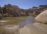
Hike to Grand Tank, Joshua Tree National Park, California
Grand Tank is a reservoir located near White Tank campgound. It only has water in it shortly after a lot of rainfall in the area. Cattle ranchers are most likely responsible for building the dam that creates Grand Tank. The trail to Grand Tank is basically due east after reaching Arch Rock. It goes through a narrow and rocky section with some scrambling. Grand Tank is... -
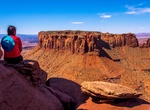
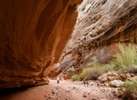
Hike to Grand View Point Overlook, Canyonlands National Park, Utah
Grand View Point Overlook in Canyonlands National Park is an easy 2.0 miles (3.2 km) walk out from parking area and a great view. -
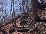
Hike Grandview Rim Trail, Grandview, West Virginia
This is the longest trail at Grandview, connecting Main Overlook with Turkey Spur. From Main Overlook to Turkey Spur is a moderate 1.6 mile hike (3.2 miles round trip). Along the way hikers will enjoy many breathtaking views of the gorge and river far below. The trail is rated moderate because of several small steep hills near Turkey Spur. A self-guided trail brochure... -
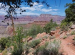
Hike Grandview Trail, Grand Canyon National Park, Arizona
The Grandview Trail is a hiking trail located on the South Rim of the Grand Canyon National Park in Arizona. This trail is VERY steep! In the summer much of the trail is in full sun. In the winter ice and snow can make hiking treacherous. Always use caution on the Grandview Trail. The trail begins at the north end of the Grandview Point parking area, off of Arizona st... -
Hike Grand Wash Trail, Capitol Reef National Park, Utah
Grand Wash Trail in Capitol Reef National Park is a 2.2 mi (3.6 km) hike through deep canyons and narrows. -
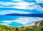
Hike to Granite Beach, Tasmania, Australia
Granite Beach is along South Coast Track in southern Tasmania, Australia. -
Hike Granite Canyon Trail, Grand Teton National Park
The Granite Canyon Trail is a 8.2 mi (13.2 km) long hiking trail in Grand Teton National Park in the U.S. state of Wyoming. The trail begins at the Granite Canyon trailhead on the Moose-Wilson Road, about 2 miles (3.2 km) north of Teton Village and ends at the junction with the Teton Crest Trail near Marion Lake. The trail follows the length of Granite Canyon. Just ov... -
Hike to Granite Mountain Hotshots Memorial Observation Deck, Arizona
Hike the Hotshots Trail from the parking lot trailhead up to the overlook where you'll see sweeping views in every direction, and perhaps leave a memento on our rememberance wall. -
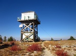
Hike to Granite Mountain Lookout, Payette National Forest, Idaho
Granite Mountain Lookout is located in Payette National Forest, Idaho. -
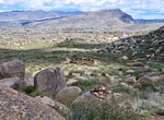
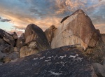
Explore Granite Mountains Nature Reserve, California
An imposing jumble of granite marks the south entrance to the preserve, 50 miles southeast of Baker on Kelbaker Road. Portions of the Granite Mountains lie within the University of California's Sweeney Granite Mountains Desert Research Center; please respect the signs that mark the boundary. The Granite Mountains is a small mountain range in San Bernardino County, Ca... -
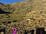
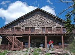
Hike to Granite Park Chalet, Glacier National Park
Granite Park Chalet is located in the heart of Glacier National Park in the U.S. state of Montana at an elevation of 6,693 feet above sea level. The chalet was built in 1914 by the Great Northern Railway and is a National Historic Landmark contributing property, being one of five structures in the Great Northern Railway Buildings district. From Logan Pass along the Go... -
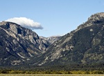
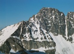
Summit Granite Peak, Montana
Granite Peak, at an elevation of 12,807 feet (3,904 m) above sea level, is the highest natural point in the U.S. state of Montana, and is the tenth highest state high point in the nation. It lies within the Absaroka-Beartooth Wilderness, in Park County very near the borders of Stillwater County and Carbon County. The hike to the summit is 21–25 miles round-trip.... -
Hike Grapevine Canyon NCA, Nevada
To many first time visitors, the Mojave Desert seems barren and desolate, but a walk through Grapevine Canyon offers another perspective. A fresh water spring flows out of the canyon floor in non-drought years. This desert spring provides life-giving water to a wide assortment of plants, including grapevines, and animals. The presence of the water and the abundance of... -
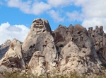
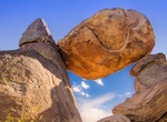
Hike Grapevine Hills Trail (Balanced Rocks), Big Bend National Park, Texas
This trail leads to a group of balanced rocks in the heart of the Grapevine Hills. Initially, the trail follows a gravel wash, then climbs steeply for the last quarter mile into the boulders. Grapevine Hills is an exposed laccolith, with many giant, rounded boulders that are tempting to climb, but watch for snakes. Begin 6 miles down Grapevine Hills improved dirt roa...
Price: $160.26