Give us feedback!


 See all

Our philosophy is simple. We want to encourage you to dream. BIG! Then we help you plan your trip, get the most out of it while you're traveling and help you share your experience with friends.
Join Now It's FREE
Dream Packages
Duration: 2 days
Price: $779.00
Price: $779.00
Duration: 30 minutes
Price: $263.77
Price: $263.77
Duration: 4 days
Price: $663.61
Price: $663.61
Duration: 12 hours
Price: $160.26
Price: $160.26
Related Categories
- Australian National Parks & Reserves
- Canadian National Parks
- Canyoneering
- Day Hikes
- Guided Hikes
- In the Mountains
- Mountaineering
- Mountains
- New Zealand Great Walks
- New Zealand National Parks
- Parks & Reserves
- Rock Climbing
- South African National Parks
- UK National Parks
- UNESCO Parks & Preserves
- US Historical Parks (NHP)
Dreams Still To Do
Checked-Off Dreams
Dreams Still To Do
Checked-Off Dreams
Advertisement
Explore Hikes & Treks
-
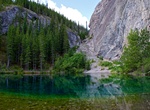
Hike around Grassi Lakes, Canmore, Alberta
The Upper and Lower Grassi Lakes lie at an elevation of about 1,525 m (5,003 ft) in the southern Canadian Rockies overlooking the town of Canmore, Alberta. They receive their water from the Spray Lakes Reservoir on the Spray River. The land is part of the Canmore Nordic Centre Provincial Park, which is part of the Kananaskis Country park system. The lakes are named af... -
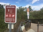
Hike or Ride Grasslands Loop, Mission Trails Regional Park, California
The Grasslands Loop is an easy 1.0+ mile trail next to Kumeyaay Lake Campground in Mission Trails Regional Park. -
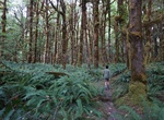
Hike Graves Creek Trail, Olympic National Park, Washington
The Graves Creek Trail is a primative trail along Graves Creek near Graves Creek Campground in the Quinault Rainforest of Olympic National Park. -
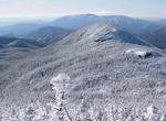
Summit Gray Peak, New York
Gray Peak is the seventh highest peak in the High Peaks Region of the Adirondack Park, in New York, USA, and is located in close proximity to Mount Marcy, the highest peak in New York state. Gray Peak is flanked to the east of Mount Colden. It was named for Asa Gray by Verplanck Colvin. Gray Peak is most frequently climbed from Lake Tear of the Clouds, with approaches... -
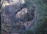
Hike Grays Arch Trail, Red River Gorge, Kentucky
Grays Arch Trail #205 begins at the Grays Arch Picnic Area off of Tunnel Ridge Road. After 1/4-mile, the trail follows Rough Trail #221 down the ridge and then off into a drain to King Branch. The trail again forks, continuing to Grays Arch. During wet weather, a beautiful waterfall occurs at the arch. Trail is located in the Red River Gorge on Cumberland Ranger Distr... -
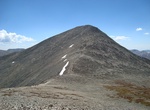
Summit Grays Peak, Front Range, Colorado
Grays Peak is the highest mountain in the Front Range of the Southern Rocky Mountains in the U.S. State of Colorado. Grays Peak is the tenth highest summit of the entire Rocky Mountains and is one of 54 fourteeners (mountains of over 14,000 feet (4,268 m) in elevation) in Colorado. Its nearest major city is Denver. Botanist Charles C. Parry made the first recorded asc... -
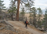
Hike Grays Peak Trail, Big Bear Lake, California
This trailhead is located on the west side of HWY 38, North Shore Drive. It is 0.6 of a mile west of Fawnskin, across from the Grout Bay Picnic Area. (This trailhead is in the center of a bald eagle wintering habitat area and is closed to all public when nesting occurs, usually from winter to spring, though it can extend into summer.) The trail climbs westerly for 0.... -
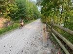
Hike or Ride Great Allegheny Passage (GAP), Maryland & Pennsylvania
The Great Allegheny Passage (GAP) is a rail trail in Maryland and Pennsylvania—the central trail of a network of long-distance hiker-biker trails throughout the Allegheny region of the Appalachian Mountains, connecting Washington, D.C. to Pittsburgh, Pennsylvania. The GAP's first 9-mile (14 km) section near Ohiopyle, Pennsylvania, opened in 1986. The 9-mile (14 ... -
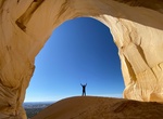
Hike to Great Chamber, Cutler Point, Utah
The Great Chamber at Cutler Point is part of the Grand Staircase Escalante National Monument near Kanab, Utah. A short hike leads to the beautiful Culter Point cave carved by the wind. To get here has two options 4WD drive is about an hour drive from Kanab with much of it on a soft sand road. 8 mile roundtrip from there. 17.6-mile round trip hike from the main pa... -
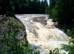
Hike to Great Conglomerate Falls, Michigan
Great Conglomerate Falls is a 30 feet (9.1 m) waterfall on the Black River in Michigan. It is split into two drops in the summertime when water is lower. The falls takes its name from the large conglomerate outcropping in the middle of the river that forms its segmented appearance. -
Trek Great Divide Trail, Canadian Rockies
The Great Divide Trail (GDT) is a wilderness hiking trail in the Canadian Rockies. The trail closely follows the Great Divide between Alberta and British Columbia, crossing the divide more than 30 times. Its southern terminus is in Waterton Lakes National Park at the Canada–US border (where it connects with the Continental Divide Trail) and its northern terminus... -
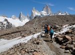
Trek Greater Patagonia Trail (GPT), Chile & Argentina
The Greater Patagonian Trail is an unofficial long-distance path in Chile and Argentina created in 2014. It runs south from Santiago, Chile, for 3,000 km (1,850 mi), and crosses five regions of Patagonia: Central Andes, Alto Bío Bío, Andean Araucanía, Valdivian Forest, and Patagonia Aysén. It ends at Mt Fitz Roy in Argentina. The trail is b... -
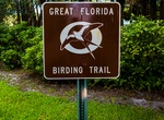
Explore Great Florida Birding Trail, Florida
Great Florida Birding and Wildlife Trail (GFBWT) is a 2,000 mile (3200 km) long collection of more than 500 locations in the U.S. state of Florida where the state's bird habitats are protected. The trail promotes birdwatching, environmental education and ecotourism. The GFBWT is a program of the Florida Fish and Wildlife Conservation Commission, supported in part by t... -
Hike Great Glen Way, Scotland
The Great Glen Way is a long distance path in Scotland. It follows the Great Glen, running from Fort William in the southwest to Inverness in the northeast, covering 125 kilometres (78 mi). It was opened in 2002, and is designated as one of Scotland's Great Trails by NatureScot. The Great Glen Way is generally walked from southwest to northeast to follow the direction... -
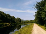
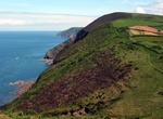
Hike Great Hangman, England
Hangman cliffs, consisting of Great Hangman and Little Hangman are near Combe Martin on the north coast of Devon, England, where Exmoor meets the sea. Great Hangman, with its summit at grid reference SS601481, is 1,043 feet (318 m) high with a cliff face of 800 feet (244 m). It is the highest sea cliff in England and the highest point on the South West Coast Path. Lit...
Price: $263.50