Give us feedback!

Our philosophy is simple. We want to encourage you to dream. BIG! Then we help you plan your trip, get the most out of it while you're traveling and help you share your experience with friends.
Join Now It's FREE
Dreams Still To Do
Checked-Off Dreams
Dreams Still To Do
Checked-Off Dreams
Advertisement
Explore Landmarks (Natural)
-
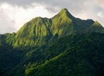
Explore Matafao Peak, American Samoa
Matafao Peak (Samoan: Fa’asi’usi’uga o Matafao) is a mountain in American Samoa, on the island of Tutuila. With an elevation of 653 meters (2,142 ft), it is the highest peak on Tutuila Island. The mountain, like Rainmaker Mountain across Pago Pago Harbor, is a remnant of a volcanic plug and is part of the volcanic origins of the island. The mountain ... -
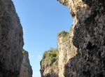
Swim at Matapa Chasm (Kings Bathing Hole), Niue
Matapa Chasm is known as the Kings Bathing Hole. Matapa Chasm is one of the few places on the island that is good for swimming at any tide. Fresh cool water from a stream made this chasm a favorite swimming place for the kings of Niue. Quite often you will see young local boys scouring the cliff face to the top before leaping back into the cool waters. -
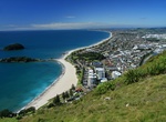
Summit Mauao (Mount Maunganui), New Zealand
Climbing up Mauao is an amazing experience with some of the best ocean and city views anywhere. There are also easy trails around the base of Mt Maunganui that wind from the ocean to the harbour. Mauao or Mount Maunganui, commonly known by locals as just The Mount, is an extinct volcanic cone at the end of a peninsula and the town of Mount Maunganui, by the eastern en... -
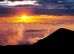
Explore Mauna Loa Volcano, Big Island, Hawaii
Mauna Loa is one of five volcanoes that form the Island of Hawaii in the U.S. state of Hawaiʻi in the Pacific Ocean, and the largest on Earth in terms of volume and area covered. It is an active shield volcano, with a volume estimated at approximately 18,000 cubic miles (75,000 km3), although its peak is about 120 feet (37 m) lower than that of its neighbor, Mauna Kea... -
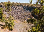
See Mauna Ulu Crater, Hawaii Volcanoes National Park, Hawaii
Mauna Uluis located on the east rift zone of Kīlauea. Mauna Ulu is approximately 400 ft. (121 meters) high from its pre-eruption base. At present Mauna Ulu Crater is approximately 100 ft. (30.5 meters) deep. It erupted in several phases from May 24, 1969 to July 22 of 1974. Mauna Ulu recorded high fountaining of 1770 ft. (539.5 meters);only second to Kīlauea Ikiʻs rec... -
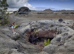
Visit Mauna Ulu Lava Flow, Hawaii Volcanoes National Park, Hawaii
The beginning of Mauna Uluʻs 1969 eruption began with a 2-3 mile fissure that opened left and right of this stop. This fissure eruption covered the portion of the Chain of Craters Road that created this stop. By being adventurous, you can walk around and view several lava tree molds and a big cinder field that was created during this lava flow. Prior to this eruption... -
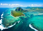
See Mauritius' Underwater Waterfall, Mauritius
The waters off Mauritius can drop off quite suddenly into the deep ocean. There arre shallower areas around Mauritius, where the underwater “waterfall” sits is at one of the points where the seabed suddenly plummets. The "waterfall" has less to do with the movement of water, and more related to the sand and silt deposits sliding down the slope. -
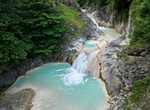
See Mavigöl Falls, Yeşilvadi, Giresun, Turkey
Waterfall tumbling down wooded cliffs into a vibrant blue waters rock pool. A viewpoint is accessed by wooden steps. -
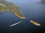
Explore Mayne Island, Gulf Islands National Park Reserve, British Columbia
Mayne Island is a rustic 21-square-kilometre (8.1 sq mi) island in the southern Gulf Islands chain of British Columbia. It is situated midway between the Lower Mainland of BC and Vancouver Island, and has a population of 1071. Mount Parke in the south-central heart of the island is its highest peak at 255 meters (837 feet). The Japanese-Canadian community on Mayne Isl... -
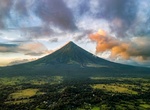
Visit Mayon Volcano Natural Park, Luzon, Indonesia
Mayon Volcano Natural Park is a protected area of the Philippines located in the Bicol Region (Region 5) on southeast Luzon Island, the largest island of the country. The Natural park covers an area of 5,775.7 hectares (14,272 acres), which includes its centerpiece Mayon Volcano, the most active volcano in the Philippines, and its adjacent surroundings. The volcano is... -
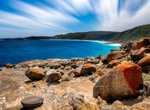
Visit McBride's Rocks, Torndirrup National Park, Western Australia
McBride's Rocks are on the cliffs in Torndirrup National Park, Western Australia. -
Hike McDermid Rock Loop, Norseman, Western Australia
McDermid Rock Loop is an easy hike that starts at MCDermid Rock Campground. -
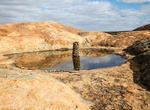
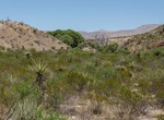
Hike to McKinney Spring, Big Bend National Park, Texas
It's a short hike to McKinney Spring from the primitive campsite. Vegetation includes creosote, lechuguilla, grasses, and shrubby mesquite. There is a small grove of cottonwood trees 0.25 miles up the nearby drainage. The wash downstream of the site provides access to the upper Tornillo Creek area. -
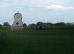
Stroll McPherson Ridge, Gettysburg National Military Park, Pennsylvania
McPherson Ridge is a landform used for military engagements during the 1863 Battle of Gettysburg, First Day, when the I Corps (Union Army) had a headquarters on the ridge and was defeated by the Confederate division of Major General Henry Heth. The ridge has terrain above ~530 ft (160 m) and is almost entirely a federally protected area except for township portions at... -
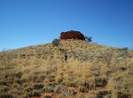
Hike to McPhersons Pillar, Gibson Desert Nature Reserve, Western Australia
McPhersons Pillar is located within Gibson Desert Nature Reserve in Western Australia.