Give us feedback!

Our philosophy is simple. We want to encourage you to dream. BIG! Then we help you plan your trip, get the most out of it while you're traveling and help you share your experience with friends.
Join Now It's FREE
Dreams Still To Do
Checked-Off Dreams
Dreams Still To Do
Checked-Off Dreams
Advertisement
Explore Landmarks (Natural)
-
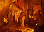
Visit Mira de Aire Caves, Leiria, Portugal
Mira de Aire Caves are a set of caves limestone located in Mira de Aire , in the municipality of Porto de Mos , in the district of Leiria in Portugal . Part of these mines called Gruta dos Moinhos Velhos is explored for tourist purposes. The caves are located in the Portuguese parish of Mira de Aire in the Estremenho Limestone Massif, on the flanks of Serra D'Aire, o... -
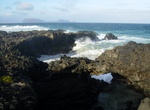
See Mirador Baja de las Majapalomas, La Graciosa Island, Canary Islands
Mirador Baja de las Majapalomas is a sea arch on the northern tip of La Graciosa Island. -
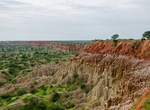
Visit Miradouro da Lua (Luanda), Angola
Miradouro da Lua, or as the translation from Portuguese would be “Viewpoint of the Moon”, is a geological set of cliffs that is located south of Luanda, on the road to Sangano. -
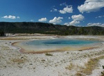
See Mirror Pool, Yellowstone National Park, Wyoming
Mirror Pool is located along the trail to Artemisia Geyser in Yellowstone National Park. -
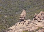
Hike Mishe Mokwa Trail to Split Rock, Westlake Village, California
Traversing riparian, coastal sage scrub, and chaparral, this trail offers wonderful views of Carlisle Canyon and Balanced Rock. Split Rock’s oak grove offers a shaded spot for picnicking. Trailhead is at Circle X Ranch. -
Explore Mission Creek Preserve, Desert Hot Springs, California
Mission Creek Preserve is a 4,760 acres reserve in Desert Hot Springs, California. -
Explore Mistaken Point, Newfoundland and Labrador (UNESCO Site)
Mistaken Point is a small Canadian headland on the Avalon Peninsula of Newfoundland in the province of Newfoundland and Labrador. It is the site of the Mistaken Point Ecological Reserve, which contains one of the most diverse and well-preserved collections of Precambrian fossils known. The site was first discovered in 1967 by S.B. Misra, a graduate student of Memorial... -
Tour Mitchell Caverns, California
The Mitchell's Caverns, within the Mitchell Caverns Natural Preserve, are a trio of limestone caves, located on the east side of the Providence Mountains at an elevation of 4,300 feet (1,300 m), within the Providence Mountains State Recreation Area. They are located in the Mojave Desert, at the north-western end of Essex Road, off of Interstate 40 (Needles Freeway) in... -
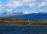
Explore Miter Peninsula, Argentina
The Miter Peninsula is known as the territory located in the southeast of the Big Island of Tierra del Fuego. It includes colonies of birds and marine mammals, extensive peat bogs and wetlands. Land access to the Miter Peninsula is through two main roads: from the north, it is accessed from Provincial Route 21 (former complementary "A"), which culminates in the Estan... -
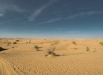
Visit Mitribah, Kuwait
Mitribah is a weather station (40551 in the World Meteorological Organization database) in northwest Kuwait. On July 21, 2016, the temperature at this location hit the second highest temperature ever reliably recorded on Earth at 54 °C (129 °F). -
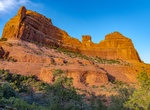
Hike or Mountain Bike Mitten Ridge, Sedona, Arizona
Beautiful hike across Sedona's Mitten Ridge. Starting from Cow Pies Trailhead, the trail crosses cowpie shaped rock formations, and joins up with what the Forest Service adopted and "improved" as "Hangover Trail" (but was known to hikers as Mitten Ridge Trail). Hangover Trail skirts along the base of Mitten Ridge on the Bear Wallow Canyon side of the ridge, jumping ov... -
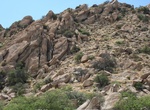
Summit Mitten Rock, San Juan County, New Mexico
Mitten Rock is a 6,557-foot (1,999 meter) elevation summit located on Navajo Nation land in San Juan County of northwest New Mexico, United States. Mitten Rock is set in the northeastern part of the Navajo Volcanic Field, a volcanic field that includes intrusions and flows of minette and other unusual igneous rocks which formed around 30 million years ago during the O... -
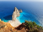
Visit Mizithres Viewpoint, Zakynthos Island, Greece
Mizithres Viewpoint is popular for photos of striking sea rocks. -
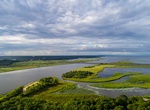
Explore Mobile–Tensaw River Delta, Alabama
The Mobile–Tensaw River Delta is the largest river delta and wetland in Alabama. It encompasses approximately 260,000 acres (110,000 ha) in a 40-by-10-mile (64 km × 16 km) area and is the second largest delta in the contiguous United States. This large river delta is approximately 45 miles long and averages 8 miles wide, being 16 miles wide at its widest p... -
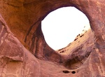
See Moccasin Arch, Monument Valley, Arizona
Moccasin Arch is a large pothole natural arch located within the boundaries of Monument Valley Navajo Tribal Park. It is located very close to Big Hogan Arch. A Navajo guide is required for any visitation.