Give us feedback!

Our philosophy is simple. We want to encourage you to dream. BIG! Then we help you plan your trip, get the most out of it while you're traveling and help you share your experience with friends.
Join Now It's FREE
Dreams Still To Do
Checked-Off Dreams
Dreams Still To Do
Checked-Off Dreams
Advertisement
Explore Landmarks (Natural)
-
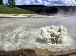
Explore Mud Volcano Group, Yellowstone National Park, Wyoming
The thermal features at Mud Volcano and Sulfur Cauldron are primarily mud pots and fumaroles because the area is situated on a perched water system with little water available. Fumaroles or "steam vents" occur when the ground water boils away faster than it can be recharged. Also, the vapors are rich in sulfuric acid that leaches the rock, breaking it down intoclay. B... -
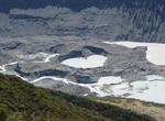
See Mueller Glacier & Lake, New Zealand
The Mueller Glacier is a 13-kilometre (8.1 mi) long glacier flowing through Aoraki/Mount Cook National Park in the South Island of New Zealand. It lies to the south of Aoraki/Mount Cook, high in the Southern Alps, and flows north. Its meltwaters eventually join the Tasman River. The glacier was named after German-Australian botanist and explorer Baron von Mueller. Bas... -
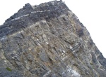
See Mugu Rock, Point Mugu State Park, California
Mugu Rock is a distinctive feature of the coastal headland promontory that has been featured in many film shoots and television commercials. This igneous dike marks the western end of the Santa Monica Mountains, and the Rancho Guadalasca boundary. The rock was formed when the roadway was cut through the near-vertical ridge of resistant volcanic rock in 1937. A route h... -
Explore Muir Woods National Monument, California
Muir Woods National Monument is a unit of the National Park Service on the Pacific coast of southwestern Marin County, California, 12 miles (19 km) north of San Francisco and part of the Golden Gate National Recreation Area. It protects 554 acres , of which 240 acres are old growth Coast Redwood (Sequoia sempervirens) forests, one of a few such stands remaining in the... -
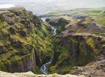
Hike Múlagljúfur Canyon, Vatnajökull National Park, Iceland
Múlagljúfur Canyon (Mules Canyon) is a nice uncrouded hike within Vatnajökull National Park and yet close to the Ring Road. It does not a well marked trail. -
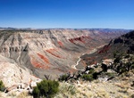
Off-road to Mule Point, Grand Canyon-Parashant National Monument, Arizona
Mule Point Road is access from BLM 1063 in Arizona. Mule Point overlooks colorful Parashant Canyon. The red layer is the Hermit Formation. If you continue south on BLM 1063 it descends the steep Trail Canyon dugway, the road follows the canyon floor toward the Grand Canyon. -
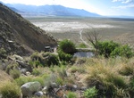
Off-road to Mule Spring, Ownes Valley, California
Mule Spring is a spring(s) and is located in Inyo County, California, United States. The elevation above sea level is 1254 metres. There is a man-made pond at the spring. -
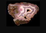
Explore Mulligan Peak, Arizona
Mulligan Peak's (Elevation: 5613 feet (1711 meters)) is well known for its purple agates. It can be found on western foothills by careful digging and are recognized by bands of color ranging from lavender to deep purple and gray. The best route to the Mulligan Peak is to hike for at least 2 miles via the Limestone Glutch along the northern side of the peak f... -
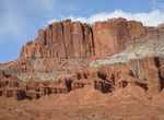
See Mummy Cliff, Capitol Reef National Park, Utah
The beautiful Mummy Cliffs are part of the 87 mile long Waterpocket Fold, the dark red Moenkopi siltstone and mudstone. -
Explore Mundoonen Nature Reserve, NSW, Australia
Mundoonen Nature Reserve was created in February 1970. It covers an area of 1471ha. It's located in New South Wales along route M31. A small population of koalas has been identified in Mundoonen Nature Reserve however little is known about their current density and distribution. -
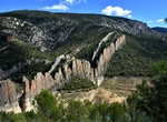
Hike to Muralla de Finestres, Huesca, Spain
Muralla de Finestres (Chinese wall of Finestres) are sheer cliffs said to resemble the Great Wall of China. There are several hiking or 4x4 ways to reach the Chinese wall of Finestres and visit the old village of Finestres and the hermitages of San Marcos and San Vicente nestled in this magical setting near the Congost de Montrebei. This 15 km walking route visits the... -
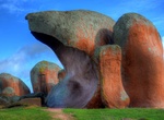
See Murphy's Haystacks, South Australia
Murphy's Haystacks are inselberg rock formations located at Mortana, between Streaky Bay and Port Kenny on the Eyre Peninsula in South Australia. They obtained their name because a traveller in a coach saw the formation in the distance. He asked how a farmer could produce so much hay. As the farm was on a property owned by a man called Murphy, the rocks became known a... -
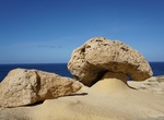
See Mushroom Rock, Gozo, Malta
Mushroom Rock (Roccoa del Fungo) is located on the northwest side of Gozo Island, Malta. -
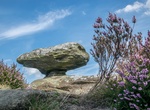
See Mushroom Rock, Brimham Rocks, North Yorkshire, England
Mushroom Rock is a rock formation at Brimham Rocks, North Yorkshire, England. -
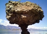
See Mushroom Rock (Isla Danzante), Baja California Sur, Mexico
Mushroom Rock on Isla Danzante looks a lot like the Mushroom Rock at Balandra (LA Paz).