Give us feedback!

Our philosophy is simple. We want to encourage you to dream. BIG! Then we help you plan your trip, get the most out of it while you're traveling and help you share your experience with friends.
Join Now It's FREE
Dreams Still To Do
Checked-Off Dreams
Dreams Still To Do
Checked-Off Dreams
Advertisement
Explore Landmarks (Natural)
-
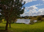
Visit Parque da Cidade, Porto, Portugal
Parque da Cidade designed by the landscape architect Sidónio Pardal, is the largest urban park in the country, occupying a total of 83 hectares and about 10 km of paths. The park is a sophisticated architectural landscape with lakes, flora and fauna , integrated into the fabric of the city. The modeling of the terrain, the stone elements and the grove create pa... -
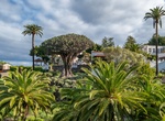
Visit Parque del Drago, Icod de los Vinos, Tenerife, Canary Islands
Drago Park (Spanish: Parque del Drago) is a park and one of the main visitor attractions in Icod de los Vinos, Tenerife. Created at the turn of the millennium, it contains El Drago Milenario, a dragon tree thought to be around 1,000 years old, as well as a variety of other native plants. The park has an area of around 3 hectares (7.4 acres). It houses the El Drago Mi... -
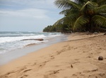
Visit Parque Nahomi, Quepos, Costa Rica
Parque Nahomi in Quepos is a beautiful small park by the ocean. Part of it has been equipped with an outdoor gym where you can exercise out in fresh air for free. -
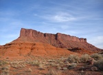
Rock Climb Parriott Mesa, Utah
Parriott Mesa is a 6,155 ft sandstone summit in Grand County of Utah, United States. Parriott Mesa is located at Castle Valley, Utah, near the city of Moab. The name honors Dale M. Parriott (1885–1958), who was a Moab settler, and owned a ranch house in Castle Valley. Parriott Mesa is a thin 0.4 mile wide, and 1.5 mile long north-to-south mesa with 400 ft vertic... -
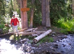
Hike to Parting of the Waters (Two Ocean Pass), Bridger-Teton National Forest, Wyoming
Parting of the Waters is an unusual hydrologic site at Two Ocean Pass on the Great Divide, within the Teton Wilderness area of Bridger-Teton National Forest, Wyoming, USA. Two Ocean Pass separates the headwaters of Pacific Creek, which flows west to the Pacific Ocean, and Atlantic Creek, which flows east to the Atlantic Ocean. In 1965, this site received designation ... -
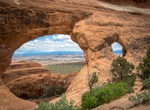
See Partition Arch, Arches National Park
Partition Arch is located on the Devil's Garden Trail in Arches National Park. At mile 1.85 on the trail turn right for a short trail to Partition Arch (0.2 miles). Navajo Arch is close. -
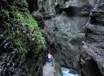
Explore Partnach Gorge, Germany
The Partnach Gorge (Partnachklamm) is a deep gorge that has been incised by a mountain stream, the Partnach, in the Reintal valley near the south German town of Garmisch-Partenkirchen. The gorge is 702 metres (2,303 ft) long and, in places, over 80 metres (260 ft) deep. It was designated a natural monument in 1912. The gorge was already being used by local people... -
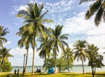
Visit Pasir Ris Park, Singapore
Pasir Ris Park is a beach park located in the eastern part of Singapore. This coastal park opened in 1989 and is among the largest in Singapore. It occupies 70 hectares of land, including some reclaimed land, and stretches over 3.2 km. There is a 6-hectare mangrove forest within the park and the Boardwalks enable visitors to explore the forest. Mud crabs, mudskippers ... -
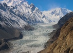
See Passu Glacier, Passu Village, Pakistan
Passu Glacier is situated in the south side of Passu village. Passu Peak is situated in the back side of the glacier. This glacier is linked with Batura Glacier and many other glaciers in Batura Muztagh mountain range. -
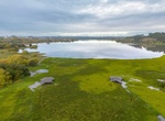
See Pateira of Fermentelos, Águeda, Portugal
Pateira of Fermentelos or simply Pateira is a pond natural, located in the triangle of municipalities Agueda , Aveiro and Oliveira do Bairro , before the confluence of the Cértima Rio with Rio Agueda . It is surrounded by the parishes of Óis da Ribeira , Fermentelos , Espinhel and Requeixo.] It is one of the largest natural lagoons of the Iberian Penins... -
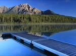
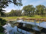
Explore Patricia & Pyramid Lakes, Jasper National Park, Canada
Pyramid Lake is kidney-shaped lake in Jasper National Park, Alberta, Canada. It lies at the foot of Pyramid Mountain, a natural landmark that overlooks the town of Jasper. It has a total area of 1.2 km2 (0.46 sq mi) and discharges in Athabasca River through the 2 km (1.2 mi) longPyramid Creek. Several picnic sites are established on the shores of the lake, as well as ... -
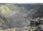
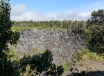
See Pauahi Crater, Hawaii Volcanoes National Park, Big Island, Hawaii
Pauahi Crateris approximately 1800-2000 ft. (548.6-610 meters) long, 300-500 ft. (90-106.7 meters) deep and 300 ft. (90 meters) wide. In November of 1973 there was an eruption that lasted 31 days, creating the present crater floor. This eruption also opened a fissure east of the crater towards Puʻuhululu. This fissure eruption became a phase of the 1969-1974 Maun... -
Visit Pauahi Crater Overlook, Hawaii Volcanoes National Park, Hawaii
Pauahi Crater is approximately 1800-2000 ft. (548.6-610 meters) long, 300-500 ft. (90-106.7 meters) deep and 300 ft. (90 meters) wide. In November of 1973 there was an eruption that lasted 31 days, creating the present crater floor. This eruption also opened a fissure east of the crater towards Puʻuhululu. This fissure eruption became a phase of the 1969-1974 Mauna U... -
Hike Paul H. Douglas Trail (Miller Woods Trail), Indiana Dunes National Park, Indiana
Paul H. Douglas Trail, formerly the Miller Woods Trail, is located off Lake Street in Gary's Miller Beach community. The trail is fully accessible from a parking lot just north of the Douglas Center for Environmental Education. Miller Woods is a trail system in the far western part of Indiana Dunes National Park in the lakefront community of Miller Beach, Indiana. Mil... -
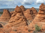
Hike to Paw Hole, South Coyote Buttes, Arizona
Paw Hole area of Coyote Buttes Special Management area is vast and remote. The trail route wanders around a lot of cool rock formations. There is no established trail. Head north-northeast to explore around the hoodoos and buttes. To access Coyote Buttes South take Paw Hole Road near the soutern part of House Rock Valley Road. From the north take House Rock Valley Roa...