Give us feedback!

Our philosophy is simple. We want to encourage you to dream. BIG! Then we help you plan your trip, get the most out of it while you're traveling and help you share your experience with friends.
Join Now It's FREE
Dreams Still To Do
Checked-Off Dreams
Dreams Still To Do
Checked-Off Dreams
Advertisement
Explore Landmarks (Natural)
-
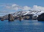
See Pete's Pillar, Deception Island, Antarctica
Pete's Pillar is a distinctive rock stack at the entrance to the flooded caldera of Deception Island, South Shetland Islands, Antarctica. -
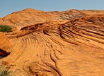
Hike Petrified Dunes Trail, Snow Canyon State Park, Utah
Petrified Dunes Trail has some steep slopes, uneven surfaces. This trail crosses massive sandstone outcrops where you may explore sand dunes frozen in time. -
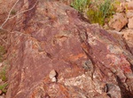
See Petrified Logs (East & West), Valley of Fire State Park, Nevada
If you want a glimpse into our planet’s prehistoric past, you might want to go check out the 150 million-year-old petrified logs in Valley of Fire State Park! Part of a forest of ancient pines that grew here during the time of the dinosaurs, these trees have laid around long enough to become fossils. What does that mean? It means that all the organic parts of th... -
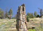
Hike Petrified Tree Trail, Yellowstone National Park, Wyoming
Petrified Tree Trail is a short 0.2 mile out and back trail that takes hikers to a upright petrified tree. It is located in Yellowstone National Park, Wyoming. -
Hike to Petroglyph Arch Rock (Barker Dam Trail), Joshua Tree National Park, California
Petroglyph Arch Rock is found along to HIdden Valley-Barker Dam Connector trail in Joshua Tree National Park. -
Visit Petrolia, California
Petrolia is an unincorporated community in Humboldt County, California, 10 miles (16 km) southeast of Cape Mendocino, at an elevation of 121 feet (37 m). Petrolia was the site of the first oil well drilled in California. It is located in the Mattole Valley, part of the Lost Coast region, one of the largest wilderness areas and the longest stretch of undeveloped coastl... -
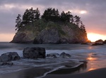
See Pewetole Island, Trinidad Head, California
Pewetole island is part of the 20,000 islands, rocks, and pinnacles that make up the California Coastal National Monument. -
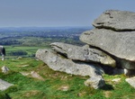
Visit Pew Tor, Dartmoor, Devon, England
A very easily accessed Tor with parking right at the base. -
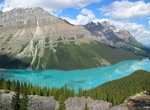
Explore Peyto Lake, Banff National Park, Canada
Peyto Lake (pea-toe) is a glacier-fed lake located in Banff National Park in the Canadian Rockies. The lake itself is easily accessed from the Icefields Parkway. It was named for Bill Peyto, an early trail guide and trapper in the Banff area. The lake is formed in a valley of the Waputik Range, between Caldron Peak, Peyto Peak and Mount Jimmy Simpson, at an elevation ... -
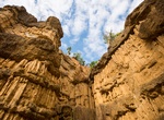
Visit Phachor Canyon, Mae Wang National Park, Thailand
Pha Chor (Thai: ผาช่อ, RTGS: Pha Cho) is a cliff located in Chiang Mai, Thailand, and is managed by Mae Wong National Park. Pha Chor is natural phenomena caused by an uplift of one of the Earth's plates and also by erosion of wind and rain. Geologists believed that a hundred or a thousand years ago this area was a part of the Ping Ri... -
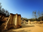
Visit Phae Mueang Phi Forest Park, Thailand
Phae Mueang Phi (Thai: แพะเมืองผี, pronounced [pʰɛ́ʔ mɯ̄a̯ŋ pʰǐː]) is a place with original rock formations in the Phi Pan Nam Range, Thailand. It is about eight kilometres northeast of Phrae town in Mueang Phrae District, Phrae Province. Named after the... -
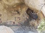
Hike to Philipps Cave, Erongo, Namibia
Phillipp’s Cave, situated on farm Ameib in the Erongo Mountains. It's 15 m deep, 35 meters long and 7 meters high. She became known due to the rock engravings found here. It was most probably one of the San dwellings. Stone tools, dated to 3500 years BC, found in the cave strongly support this assumption. -
Hike to Phipps Arch & Maverick Natural Bridge, Utah
The trail is 8.8 miles (round trip) to Phipps Arch and 10.4 miles (round trip) to Maverick Bridge. Phipps Arch stands high atop the north wall of Phipps Wash surrounded by sandstone knobs. The trailhead is located off Hwy 12 west of Escalante, Utah. -
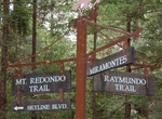
Hike Phleger Estate Park, California
The Phleger Estate is a park in San Mateo County, California. The park is located outside the town of Woodside and adjacent to Huddart County Park. There are several hiking trails through the park, access is limited to hikers and equestrians (on some trails). The trails are marked with unique trail signs and pass through a mix of second growth redwood forests and... -
Hike Phnom Kulen Mountain, Siem Reap, Cambodia
Phnom Kulen, also romanized as is a mountain range and a part of Phnom Kulen National Park in Siem Reap Province, Cambodia. Rather than a hill range, Phnom Kulen is an isolated chain of small mountain plateaux of moderate height lying south of the Dângrêk Mountains. The range stretches for about 40 km in a WNW - ESE direction and is located some 48 km nort...