Give us feedback!

Our philosophy is simple. We want to encourage you to dream. BIG! Then we help you plan your trip, get the most out of it while you're traveling and help you share your experience with friends.
Join Now It's FREE
Dreams Still To Do
Checked-Off Dreams
Dreams Still To Do
Checked-Off Dreams
Advertisement
Explore Landmarks (Natural)
-
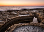
Visit Saline, Wied il-Għajn, Malta
One of the few salt pans to find on the island, especially in the southern region. They are not in use anymore but add to the beautiful promenade. -
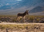
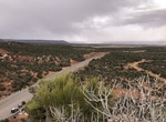
Explore Saline Valley, Death Valley National Park, California
Saline Valley is a large, deep, and arid valley in the northern Mojave Desert of California. Most of it became a part of Death Valley National Park when the park expanded in 1994. This area had previously been administered by the BLM. It is located northwest of Death Valley proper, south of Eureka Valley, and east of the Owens Valley. The valley's lowest elevatio... -
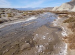
See Saline Valley Dry Lake Bed, Death Valley National Park, California
Saline Valley Dry Lake Bed is located in the middle of the Saline Valley in Death Valley National Park, California. In the winter it can have water. -
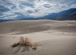
Hike Saline Valley Sand Dunes, Death Valley National Park, California
Saline Valley Sand Dunes are low dunes surrounding a dry lake located in Death Valley National Park, California. The area is large but pretty isolated. Sandboarding is not allowed. -
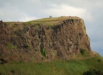
See View from Salisbury Crags, Holyrood Park, Edinburgh, Scotland
Salisbury Crags are a series of 46-metre (151 ft) cliffs at the top of a subsidiary spur of Arthur's Seat which rise on the west of Holyrood Park. Below the foot of the cliffs is a large and steep talus slope falling to the floor of Holyrood Park with a track known as the Radical Road running in the space between the two. This track was given its name after it was p... -
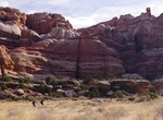
Hike Salt Creek Canyon to Angel Arch, Canyonlands National Park, Utah
Salt Creek Canyon stretches from the southern boundary of The Needles and ends at the Colorado River. The upper section of the canyon is a popular area for backpacking. Most backpackers spend 2-3 nights in Salt Creek Canyon. Due to deep sand and dense vegetation along the trail, it is not recommended to attempt a thru hike in two days or less. The 22.5 miles (34 km) o... -
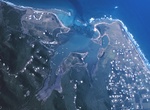
See Salt River Bioluminescent Bay, St. Croix, USVI
Salt River is home to one of two Bioluminescent Bays or Bio Bays on the island of St Croix (a second Bio Bay can be found at Altona Lagoon). Every year thousands of people flock to see the glowing water of the Bio Bay that's created by a micro-organism, the dinoflagellate Pyrodinium bahamense. The bay is also home to other bioluminescent marine life includingCtenophor... -
Explore Salt Spring Hills, Mojave Desert, California
The Salt Spring Hills are a low mountain range in the Mojave Desert, in northern San Bernardino County, California. They are just outside the southeastern corner of Death Valley National Park, southeast of the Saddle Peak Hills. The road between Shoshone and Baker passes through the hills. From 1831 to 1848, the Old Spanish Trail passed from Salt Spring on Salt Creek ... -
Hike Salvation Knoll, Utah
Salvation Knoll is a historic site located a few miles off the Hole-in-the-Rock Trail on Cedar Mesa. This trail was blazed by Mormon pioneers during the winter of 1879-1880 as they came to settle along the San Juan River. Scouts exploring in advance of the wagon train through the terribly rugged terrain became lost and ran out of food as they sought to determine wheth... -
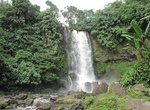
See Sampuren Putih Waterfall, Sumatra, Indonesia
Sampuren Putih is a seven-storey waterfall having 150m in height. You can see only the first level from the ground, others require a difficult, slippery hike. -
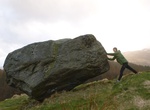
Hike to Samson's Putting Stone, Bochastle, Scotland
Samson's Putting Stone is a massive boulder deposited by a glacier on top of a hill overlooking Callander. The boulder is said by legend to be a putting stone used in a game between giants – although it is more probable that a glacier left it there. -
Visit Samurai Hell, Iwo Jima, Japan
It is a pond with intense boiling water vapor and sulfur smell. It is said to have been named Samurai Hell because it was cloudy in pale color. -
Hike San Andres Oasis Trail, Salton Sea, California
A visit to a beautiful little oasis near Dos Palmas east of the Salton Sea. It's a dirt road to get to the trailhead. Also a restroom at the trailhead. -
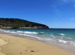
Visit Sand Beach, Acadia National Park, Maine
Sand Beach is a nice small beach (290 yards long) in Acadia National Park. It's a nice spot to enjoy the scenery and walk around. The trails loop and don't take too long, and offer a lot of beautiful spots to stop.The waterline can vary quite a bit because of the difference between high and low tide. Sand Beach is off-limits to pets June 15-September 8. -
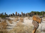
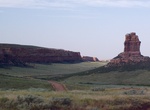
Explore Sand Creek, Wyoming & Colorado
Sand Creek is a stream noted for the "most spectacular examples of cross-bedded sandstone and topple blocks in North America". Sand Creek flows from the Laramie Mountains in Larimer County, Colorado into Albany County, Wyoming where it joins the Laramie River. The area where Sand Creek crosses the border between Colorado and Wyoming was designated a National Natural L...